

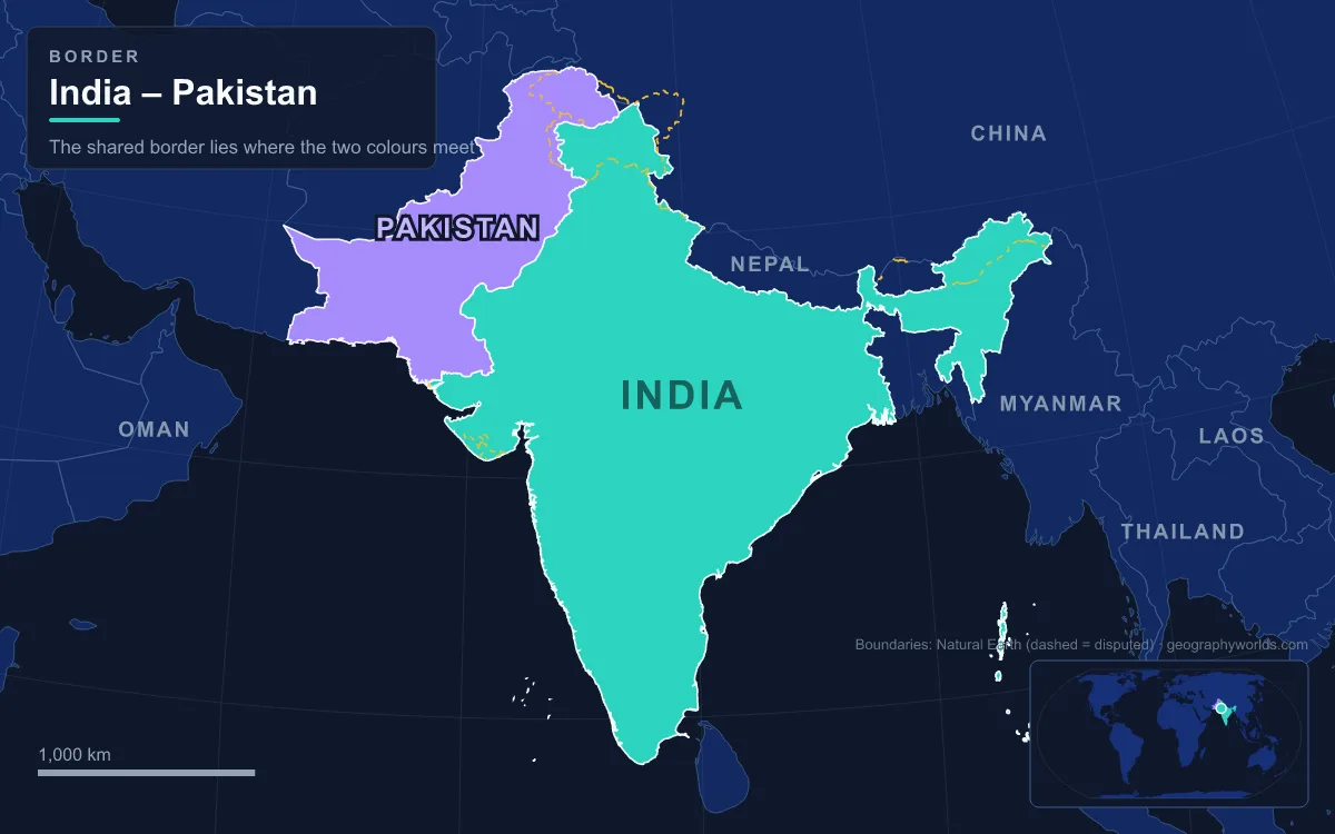
The India-Pakistan border is the boundary between India and Pakistan, and it runs about 3,323 km (2,065 miles) from Sir Creek on the Arabian Sea to the Siachen Glacier in the Karakoram. It is really several lines joined end to end. In the south, an International Boundary recognised by both countries separates Gujarat, Rajasthan and Indian Punjab from Sindh and Pakistani Punjab. North of that, a short Working Boundary meets Jammu. Beyond it the Line of Control (LoC) divides Indian-administered Jammu and Kashmir and Ladakh from Pakistani-administered Azad Kashmir and Gilgit-Baltistan, and the Actual Ground Position Line runs along the Saltoro Range beside the Siachen Glacier. The best-known crossing is Attari–Wagah, between Amritsar and Lahore. The border matters because it separates two nuclear-armed states that have fought several wars across it, and because India has lit so much of it with floodlights, some 150,000 of them on about 50,000 poles, that it can be seen from space at night. Each section was drawn at a different moment, by a different method, and in that order it is easiest to follow.
Radcliffe's Five Weeks in the Summer of 1947
The Indian Independence Act of 18 July 1947 gave Britain one month to leave India and divide it into two dominions. Most provinces went whole: Sindh, Baluchistan and the North-West Frontier Province to Pakistan, and those with Hindu majorities to India. Punjab (55.7 percent Muslim) and Bengal (54.4 percent) had no clear majority, so each had to be split. In June 1947 Britain appointed Sir Cyril Radcliffe, a British lawyer who had never been east of Paris, to chair both boundary commissions. He arrived in India on 8 July. Each commission had two members nominated by the Congress and two by the Muslim League, and because they deadlocked, the lines were in practice his alone. Across the two provinces he was dividing about 450,000 km² and 88 million people.
Radcliffe's instructions were to separate "contiguous majority areas of Muslims and non-Muslims" while taking account of undefined "other factors" such as rivers, railways and irrigation canals. He objected to the deadline, but Lord Mountbatten had accepted the viceroyalty on the condition of an early handover. The award was submitted on 9 August and held back until 17 August 1947, two days after both countries became independent. In Punjab it left Lahore in Pakistan and Amritsar, home of the Sikhs' Golden Temple, in India. About 14 million people then crossed the new border in both directions, and somewhere between 200,000 and 2 million were killed in the violence. Radcliffe refused his salary of 40,000 rupees.
Outside Punjab, the line was not Radcliffe's at all. From the edge of Punjab south to the Rann of Kutch, the border simply followed old boundaries between the province of Sindh and the princely states that became Rajasthan and Gujarat. That is why the desert stretch is straighter and was argued over less than the Punjab one, except at its southern end. The divisions of 1947 are traced in more depth in our guide to the historical geography of the Partition of India.

The Karachi Agreement's Ceasefire Line of 1949
Partition left the princely state of Jammu and Kashmir undecided. India based its claim on the ruler's accession, Pakistan on the state's Muslim-majority population, and fighting began in 1947. After a ceasefire brokered by the United Nations took hold on 31 December 1948, military representatives signed the Karachi Agreement on 27 July 1949 under the supervision of the UN Commission for India and Pakistan. It set a ceasefire line about 830 km long, running in an arc from just west of the Chenab River in Jammu north and then northeast to a map point called NJ9842, about 19 km north of the Shyok River.
Two gaps left by that agreement shaped everything that followed. Beyond NJ9842 the line was only said to run due north to the Chinese frontier, roughly 60 to 65 km away, and no one marked it, because no troops were in that frozen country. At the southern end, the stretch between the ceasefire line and Punjab followed the old boundary between Punjab and the princely state. India calls that stretch part of the international border; Pakistan calls it a "working boundary". Both terms are still in use. The United Nations Military Observer Group in India and Pakistan was set up to watch the line and still exists, though its role shrank after 1971. The competing claims over the former princely state are covered in our explainer on the Kashmir border dispute.
The Rann of Kutch Tribunal of 1968
The southern end of the border runs through the Rann of Kutch, a seasonal salt marsh that lies mostly in Gujarat, with a smaller part in Sindh. The Sindh–Kutch boundary there was disputed from 1956. In January 1965 Pakistani patrols entered territory India held; on 8 April both sides attacked each other's posts, and Pakistan's Operation Desert Hawk took several Indian positions near Kanjarkot. British Prime Minister Harold Wilson persuaded both sides to stop, and on 30 June 1965 they agreed to international arbitration. The tribunal's award in 1968 gave Pakistan about 780 km² of the Rann, against the roughly 9,100 km² it had claimed; the rest stayed with India.
The award fixed the land line, but not its mouth. Sir Creek, a 96 km tidal estuary in the Indus delta that the 24th parallel crosses, is still disputed. It matters beyond the marsh, because maritime boundaries are drawn out from points on land: settling the creek would fix where each country's exclusive economic zone begins in the Arabian Sea, over a sea bed thought to hold oil and gas. Until then, fishing crews from both sides are regularly arrested for straying across an invisible line. The creek floods between June and September, is home to Russell's vipers and scorpions, and has no fence. Meanwhile the Rann of Kutch fighting helped lead to the wider war of August and September 1965, which ended with the Tashkent Declaration of 10 January 1966; both sides agreed to withdraw to their pre-August lines by 25 February 1966, leaving the border where it had been.
From Simla in 1972 to Siachen in 1984
The war of 1971, which ended with the independence of Bangladesh, moved the Kashmir front only slightly, but it changed what the line was called. In the Simla Agreement of 2 July 1972 the two governments renamed the ceasefire line the Line of Control and agreed that "neither side shall seek to alter it unilaterally, irrespective of mutual differences and legal interpretations". India returned more than 13,000 km² of Pakistani territory taken in the war but kept a few strategic areas, among them Turtuk and neighbouring villages in the Chorbat Valley of Ladakh, more than 883 km² in all. The LoC as it stands today runs for roughly 740 to 776 km depending on the source.
The unmarked stretch north of NJ9842 became a battlefield twelve years later. Both armies had planned to occupy the Siachen Glacier. India moved first with Operation Meghdoot on 13 April 1984, four days before Pakistan's planned Operation Ababeel, and took almost the entire glacier. The two sides have faced each other there ever since, along the 110 km Actual Ground Position Line on the Saltoro Range, among peaks above 7,000 m and in temperatures as low as −55 °C. It is widely called the highest battleground in the world.
Kargil, Kartarpur and the 2025 Closures at Attari–Wagah
The Line of Control was tested again between May and July 1999, when Pakistani troops, disguised at first as Kashmiri militants, occupied heights on the Indian side around Kargil in Ladakh; the Indian Army and Air Force retook most of them. After a ceasefire in November 2003, India completed a fence along about 550 km of the LoC by 2004. On the International Boundary, India had fenced 2,064 km by 2024, and in February 2025 it began a 1,450 km patrol road along the fence through Punjab and Rajasthan.
The crossings reflect the relationship as a whole. At Attari–Wagah, on the Grand Trunk Road 32 km from Amritsar and 24 km from Lahore, India's Border Security Force and the Pakistan Rangers have lowered their flags together every evening since 1959, with high kicks, stamping and a final handshake. A suicide bombing on the Pakistani side after the ceremony on 2 November 2014 killed about 60 people. The Kartarpur Corridor, opened in November 2019 for the 550th anniversary of Guru Nanak's birth, let Indian pilgrims walk without a visa to Gurdwara Darbar Sahib, 4.7 km inside Pakistan. After an attack at Pahalgam in Indian-administered Kashmir killed 26 civilians on 22 April 2025, India accused Pakistan of backing cross-border terrorism, which Pakistan denied. India suspended the Indus Waters Treaty and closed both Attari and its side of Kartarpur on 1 May; Pakistan responded by suspending the Simla Agreement. India said its strikes on 7 May, Operation Sindoor, targeted militant infrastructure; Pakistan said civilian sites were hit, and four days of fighting ended in a ceasefire on 10 May. The flag ceremony resumed in a changed form on 20 May 2025.

Other crossings have opened and shut in the same rhythm. The Munabao–Khokhrapar rail link through the Thar Desert, closed after the 1965 war, reopened in 2006 for the Thar Express and closed again in 2019. Smaller flag ceremonies take place at Hussainiwala–Ganda Singh Wala near Firozpur and at Sadiqi–Sulemanki near Fazilka. For the rest of Pakistan's frontiers, with Afghanistan, Iran and China, see our guide to the countries that border Pakistan.