

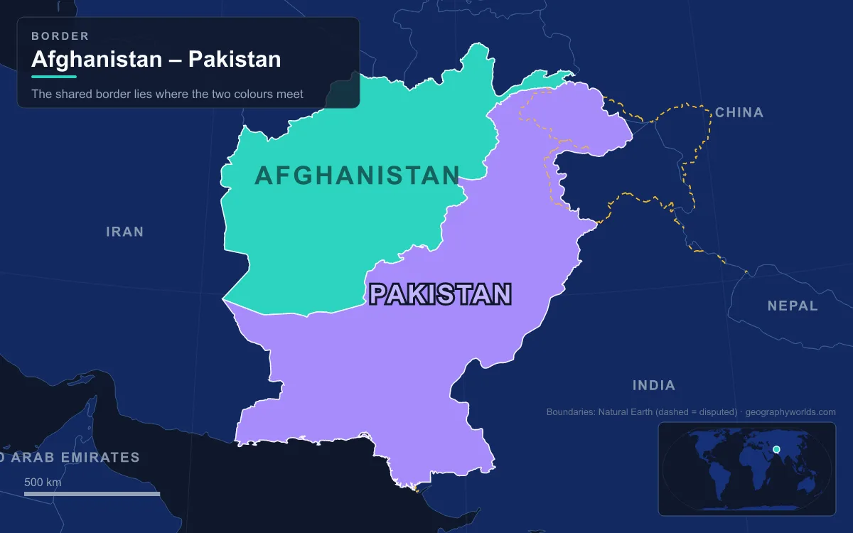
The Durand Line is the border between Afghanistan and Pakistan, a mountain-and-desert frontier of roughly 2,640 km that runs from the Iranian tripoint at Koh-i-Malik Siah to the Chinese border at the eastern tip of the Wakhan Corridor. It was fixed on 12 November 1893 by Sir Mortimer Durand, a British Indian diplomat, and Abdur Rahman Khan, the Emir of Afghanistan, then surveyed on the ground between 1894 and 1896. Pakistan inherited it in 1947 and most of the world treats it as Pakistan’s western border, but no Afghan government since 1947 has formally accepted it. It matters because it splits the Pashtun and Baloch peoples between two states, carries the main land route between Central Asia and the Indian subcontinent through the Khyber Pass, and has been the setting for more than a century of wars, raids and closures.
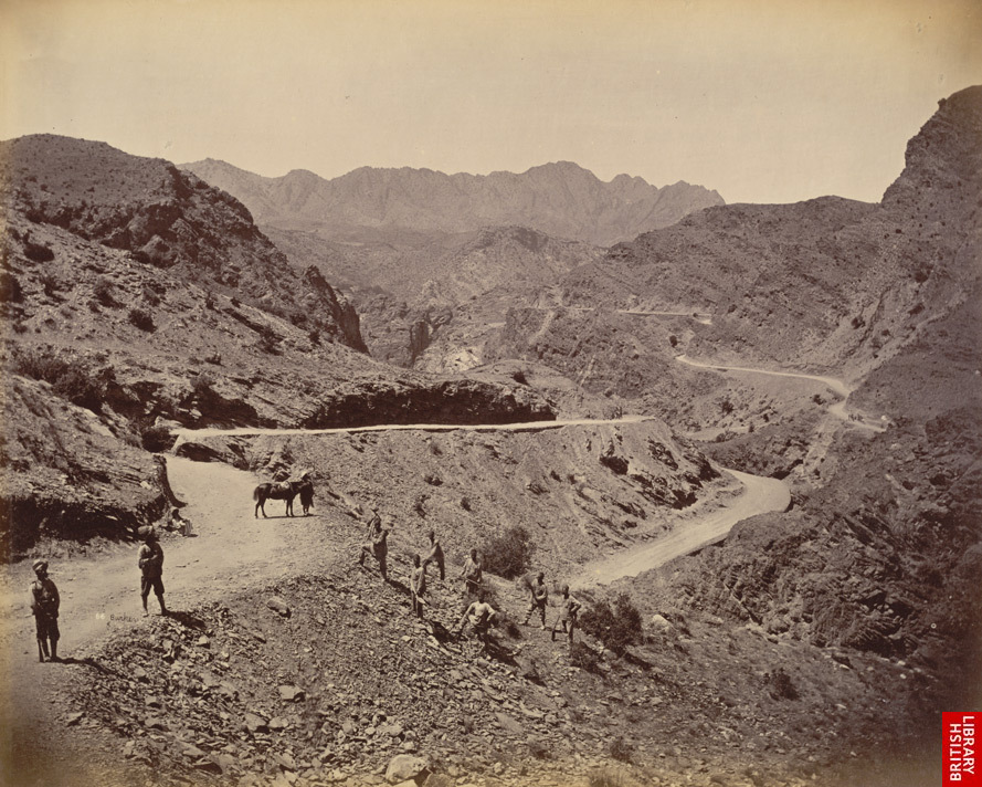
Gandamak, 1879: The Frontier Before Any Line
Before 1893 there was no agreed boundary at all, only a zone of shifting influence between the Afghan emirs in Kabul and the British in Peshawar. The Sikhs had taken Peshawar from the Afghans in 1834, and it later passed to British India. Britain first tried to settle the Afghan question by force in the First Anglo-Afghan War of 1839–1842, which ended in a British defeat.
The second attempt went better for London. In November 1878, two months after a British mission was turned back at Ali Masjid in the Khyber Pass, British Indian columns advanced through the Khyber, the Kurram valley and Quetta. The Treaty of Gandamak, signed on 26 May 1879 at a British camp about 110 km east of Kabul, made Emir Mohammad Yaqub Khan cede several frontier districts and hand control of Afghan foreign affairs to the British. The Khyber had become a British military road. After further fighting and the British victory at Kandahar in 1880, Britain backed Abdur Rahman Khan as emir. He would prove a hard bargainer, and it was he who asked the Viceroy in October 1882 for a proper boundary.
Kabul, 12 November 1893: Seven Articles on a Single Page
The Viceroy, Lord Lansdowne, first proposed sending Frederick Roberts, but Abdur Rahman refused a general who had fought against Afghanistan in 1878–1880. Instead Mortimer Durand, Foreign Secretary of the Government of India, travelled to Kabul in 1893. The agreement he and the emir signed was one page long, with seven short articles, written in English with translated copies in Dari. Its central promise was that neither side would interfere in the territory on the other side of the line.
The trade-offs were concrete. Afghanistan received Kafiristan (today’s Nuristan) and gave up its claims to Waziristan and Chagai. The emir was allowed to import arms through British India, and his annual subsidy rose from 1.2 million to 1.8 million rupees. The deal also belonged to the “Great Game” with Russia: combined with the Pamir Boundary Commission protocols of 1895, it created the Wakhan Corridor, a strip of Afghan territory only 18 km wide at Ishkashim, so that Russian Turkestan and British India would never touch. At its eastern end the corridor meets China along a 92 km boundary.

Three Boundary Commissions, 1894–1896
A line on a map in Kabul still had to be walked. The joint British-Afghan demarcation of 1894–1896 covered about 1,300 km and produced detailed topographic sheets locating hundreds of boundary pillars, now held in the Survey of India collection at the British Library. The work was split between three commissions, from north to south.
- Asmar Boundary Commission. Richard Udny, Commissioner of Peshawar, met the Afghan commander-in-chief Ghulam Haidar Khan at Jalalabad on 21 August 1894. The Afghans immediately claimed the Bashgal and Nasrat valleys, which the 1893 text had placed in Chitral, and work stalled for four months. A new agreement signed at Nashagam on 9 April 1895 gave both valleys to Afghanistan. The commission marked about 210 km from Nawa Kotal to the Hindu Kush, then deadlocked again over Bajaur.
- Afghan-Waziristan Commission. Covering Sikaram to Domandi, it finished by March 1895, and both the emir and the Viceroy ratified its maps.
- Baluch-Afghan Commission. Arthur Henry McMahon, later remembered for the McMahon Line in the eastern Himalaya, led the British side along some 330 miles (about 530 km) from Domandi to Koh-i-Malik Siah, where British India, Afghanistan and Persia met. The section to Chaman was signed off on 26 February 1895; the desert stretch beyond it, slowed by fresh Afghan claims, was completed on 13 May 1896.
In 1896 the long northern stretch from the Kabul River to China was declared demarcated without pillars, because it followed a continuous watershed ridge. That is why the line climbs over the Hindu Kush, touching the summit of Noshaq (Afghanistan’s highest peak), before running south past the Spin Ghar range, across the Kunar, Kabul, Kurram and Gomal rivers, and out into the Registan Desert to end near the Godzareh Depression. The costs were local: Abdur Rahman used his new freedom to conquer Kafiristan in 1895–1896, while Chitral lost its only all-weather route to Dir and was cut off each winter until the Lowari Tunnel was built.
Khyber, 1919–1921: The Third Anglo-Afghan War and the Treaty of Rawalpindi
One gap remained: the stretch through the Khyber and Mohmand country. It was filled only after another war. On 3 May 1919 the new emir, Amanullah Khan, sent troops into British India. The invasion was pushed back, and Royal Air Force squadrons bombed Kabul and Jalalabad. An armistice took effect on 3 June.
The peace conference at Rawalpindi was bad-tempered. The Afghans demanded sovereignty over the whole tribal belt, and the British delegation under Sir Hamilton Grant sent an ultimatum on 1 August. The Treaty of Rawalpindi, signed on 8 August 1919, gave Afghanistan control of its own foreign policy but required it to accept the Indo-Afghan frontier “accepted by the late Amir”. Between 23 August and 2 September 1919 a joint commission under Ghulam Nabi Khan and John Maffey marked the missing section from Nawa Kotal to Sikaram. The Anglo-Afghan treaty of 22 November 1921, signed by Mahmud Tarzi and Henry Dobbs, confirmed the frontier again, and so did a further agreement in 1930. A small adjustment at Arundu (Arnawai) in 1933–1934 recognised the Dokalim area, taken by Afghanistan in 1912, as Afghan territory.
1947 and the Kabul Loya Jirga of 26 July 1949
When British India was partitioned in 1947, Pakistan took over the 1893 agreement and the 1919 treaty. Its position, backed by the principle of uti possidetis juris, is that boundary treaties pass to successor states automatically and cannot be cancelled by one party alone. Pashtuns in the frontier districts were offered a choice between India and Pakistan, with no option of joining Afghanistan.
Afghanistan rejected this position outright. After a Pakistan Air Force aircraft bombed a village on the Afghan side in response to cross-border attacks, a loya jirga met in Kabul on 26 July 1949 and declared that Afghanistan recognised “neither the imaginary Durand nor any similar line”, calling all earlier agreements void and signed under duress. Others lined up behind Pakistan’s view: the British government told the House of Commons in 1950 that Pakistan had inherited the old Government of India’s rights and that the Durand Line was the international frontier, and the SEATO ministerial council at Karachi in 1956 said the same. A popular claim that the treaty “expired” in 1993, a century after it was signed, has no basis, since the text contains no time limit.
The refusal has survived every change of regime in Kabul. The Taliban declined to endorse the line in 2001, arguing there should be no borders among Muslims, and President Hamid Karzai said in 2017 that Afghanistan would never recognise it. Afghanistan’s own mapping agency nonetheless draws it as a de facto international boundary. Not every Afghan politician agrees with the official position either: the Tajik politician Abdul Latif Pedram publicly recognised the line in April 2017, and so did the Hazara leader Haji Muhammad Muhaqiq in April 2026.
Torkham, Chaman and the Fence Built Since 2017
For most of its history the line was barely policed. Pashtun families crossed it to visit relatives or find work, usually through the many mountain passes. Torkham, 5 km west of the Khyber summit at the end of Pakistan’s N-5 highway, was the first point of entry for many of the roughly 3.5 million Afghans who fled the Soviet invasion. In the south, Chaman faces the Afghan town of Spin Boldak on the road to Kandahar.
Friction over where exactly the line runs has been constant, not least because rival maps differ by as much as 5 km in places. In July 2003 the two armies clashed over posts in the Yaqubi area near Mohmand, later found to lie in Afghanistan. In 2007 Afghan troops removed fencing Pakistan had put up near the bazaar of Angoor Ada in South Waziristan.

Pakistan finally chose to close the line physically. In June 2016 it reported 1,100 km of trenches along the Balochistan section, and in March 2017 it began a fence across the full length, backed by forts and border posts. About 900 km was complete by January 2019, at a projected cost of at least $532 million; by April 2023, 98% of the fencing and 85% of the planned fortifications were finished. Closures became a political tool too: after a bombing at Sehwan in February 2017, Pakistan shut Torkham and Chaman for 32 days, then closed them again for 22 days that May, and an Afghan diplomat at the World Trade Organization put Afghanistan’s losses at about $90 million. Armed clashes between the two states in 2026 showed that the questions settled on paper in 1893 are still open on the ground. For the history of the pass at the heart of the story, see our guide to the Khyber Pass; for the other five countries around Afghanistan, read which countries border Afghanistan; and for the line McMahon drew two decades later in the eastern Himalaya, turn to the McMahon Line.