
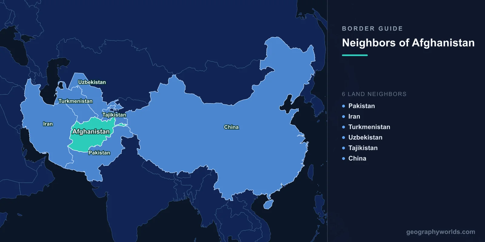
Afghanistan shares land borders with 6 countries: Pakistan (2,670 km), Iran (921 km), Turkmenistan (804 km), Uzbekistan (144 km), Tajikistan (1,357 km), and China (76 km via the Wakhan Corridor), totaling approximately 5,972 km of land boundaries.
Introduction
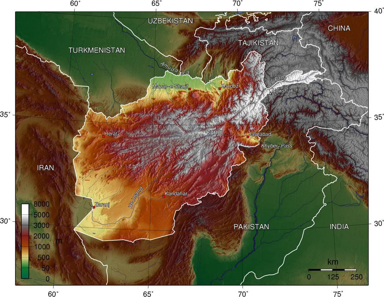
Landlocked at the crossroads of Central and South Asia, Afghanistan occupies one of the most geographically and strategically significant positions in the world. Known historically as the "Graveyard of Empires," its mountainous terrain and border regions have been corridors of trade, invasion, and cultural exchange for millennia. The Hindu Kush mountain range dominates the country, and its borders traverse high mountain passes, arid deserts, and fertile valleys. Afghanistan's six neighbors represent a complex mix of regional powers and interests.
Complete List of Countries Bordering Afghanistan
- Pakistan: 2,670 km
- Tajikistan: 1,357 km
- Iran: 921 km
- Turkmenistan: 804 km
- Uzbekistan: 144 km
- China: 76 km
Afghanistan's six borders total nearly 6,000 km, all running through mountainous or desert terrain. The country is completely landlocked, depending on its neighbors for all trade access to the outside world. Pakistan provides the primary trade and transit route via the Khyber Pass and the port of Karachi.
The Durand Line: Pakistan
- Border length: 2,670 km — Afghanistan's longest border
- Established: 1893 by Sir Mortimer Durand, splitting Pashtun territories
- Key crossings: Khyber Pass, Spin Boldak-Chaman, Torkham
The Durand Line, established in 1893 between British India and Afghanistan, stretches 2,670 km through some of the most rugged terrain on Earth. This border divides the Pashtun ethnic group, with roughly 50 million Pashtuns living on the Pakistani side and 15 million on the Afghan side. No Afghan government has ever formally recognized the Durand Line as a legitimate international boundary.
The Khyber Pass, perhaps the most famous mountain pass in the world, crosses this border at an elevation of 1,070 meters. It has been a gateway for invaders, traders, and migrants for thousands of years — from Alexander the Great to Mughal emperors to modern military operations. The Torkham and Spin Boldak-Chaman crossings handle the bulk of Afghan-Pakistani trade. Pakistan has been constructing a fence along the border since 2017, a project Afghanistan has opposed.
Western Border: Iran
- Border length: 921 km — through desert and mountain terrain
- Key issues: Water disputes over the Helmand River, drug trafficking, refugee flows
The Afghan-Iranian border runs 921 km through the arid Sistan Basin in the south and mountainous terrain in the north. The Helmand River, which flows from the Afghan highlands into Iran's Sistan region, has been a persistent source of tension. Iran depends on this water for agriculture in one of its driest provinces, and disputes over water-sharing have strained relations for decades.
Iran hosts approximately 3-4 million Afghan refugees and migrants, making the border a constant point of cross-border movement. Drug trafficking is a major concern — Afghanistan's opium production flows through Iran toward Europe, and Iran has built barriers and deployed significant military resources along this frontier.
Northern Borders: Central Asian Nations
- Turkmenistan border: 804 km — follows the Amu Darya River and Karakum Desert edge
- Uzbekistan border: 144 km — Afghanistan's shortest major border
- Tajikistan border: 1,357 km — through the Pamir and Hindu Kush mountains
Afghanistan's northern borders with the three Central Asian republics follow the Amu Darya (Oxus) River for much of their length. The Turkmenistan border (804 km) runs through flat desert terrain. Turkmenistan maintains strict neutrality and has built fences along portions of this border.
The Uzbekistan border is just 144 km but includes the Friendship Bridge at Hairatan, a critical supply route. During the Soviet-Afghan War, this bridge was used by Soviet forces entering and later withdrawing from Afghanistan.
The Tajikistan border (1,357 km) traverses the most mountainous terrain of any Afghan frontier, crossing the Pamir and Hindu Kush ranges. This border is a major drug trafficking route — Afghan opium transits through Tajikistan into Central Asian and Russian markets. Both countries share the Tajik language, creating cultural ties that span the border.
The Wakhan Corridor: China
- Border length: 76 km — through the remote Wakhan Corridor
- Elevation: Border crossing point at approximately 4,923 meters
- Access: No official border crossing exists
Afghanistan's 76 km border with China is one of the most remote and inaccessible frontiers in the world. It exists because of the Wakhan Corridor, a narrow panhandle of Afghan territory created by the Great Game between the British and Russian empires in the 19th century. The corridor was designed as a buffer zone to prevent direct contact between Russian and British territories. The border sits at extreme altitudes in the Pamir Mountains, and there is no official crossing point. The terrain is so harsh that the area is inhabited only by small communities of Wakhi and Kyrgyz herders.
Historical Border Changes
Afghanistan's borders were largely shaped by the competition between the British and Russian empires during the "Great Game" of the 19th century. The Durand Line (1893) defined the eastern border with British India, while various Anglo-Russian agreements established the northern boundaries. The Wakhan Corridor was created in 1893 specifically as a buffer between the two empires. Afghanistan's borders have remained largely unchanged since, though the Durand Line's legitimacy remains disputed. The Soviet invasion (1979-1989), the Taliban era, the US-led intervention (2001-2021), and the Taliban's return to power in 2021 have all profoundly affected border dynamics without changing the lines themselves.
Key Facts
- Afghanistan borders 6 countries with nearly 6,000 km of land boundaries
- The Durand Line with Pakistan (2,670 km) has never been formally accepted by any Afghan government
- The Wakhan Corridor gives Afghanistan a 76 km border with China at extreme altitude
- The Khyber Pass has been a vital route for trade and invasion for over 2,000 years
- Afghanistan is completely landlocked, relying on neighbors for all maritime trade access
Fun Facts
- The Wakhan Corridor, which gives Afghanistan its border with China, was created purely as a buffer zone to keep the British and Russian empires apart during the Great Game.
- The Khyber Pass has been used by everyone from Alexander the Great to Genghis Khan to modern NATO supply convoys.
- Afghanistan's border with Uzbekistan includes the Friendship Bridge — built by the Soviets to invade in 1979 and later used for their withdrawal in 1989.
- The Durand Line splits the Pashtun people between two countries — there are more Pashtuns in Pakistan than in Afghanistan.
Final Thoughts
Afghanistan's six borders reflect its position at one of the world's most critical crossroads. From the disputed Durand Line with Pakistan to the impossibly remote Wakhan Corridor reaching China, from the drug-trafficking routes through Iran to the old Soviet invasion corridor through Uzbekistan, Afghanistan's frontiers have been at the center of great power competition for centuries and remain among the most strategically significant borders in the world.
Test Your Knowledge!
Think you know your borders and boundaries? Try our interactive geography quiz!
Play Geography Games →