

The Russia–China border is a 4,209-kilometre boundary in two pieces: a short 55-kilometre stretch of snow and rock in the Altai Mountains between Russia’s Altai Republic and China’s Xinjiang, and a far longer eastern section of more than 4,000 kilometres that runs from the Mongolian tripoint along the Argun, Amur and Ussuri rivers, across Lake Khanka and down to the Tumen River, just short of the Pacific. Mostly a river frontier, it separates the sparsely settled Russian Far East from the crowded farmland of Heilongjiang and Inner Mongolia, and its final demarcation in 2008 closed a dispute that brought the two countries to open fighting in 1969.
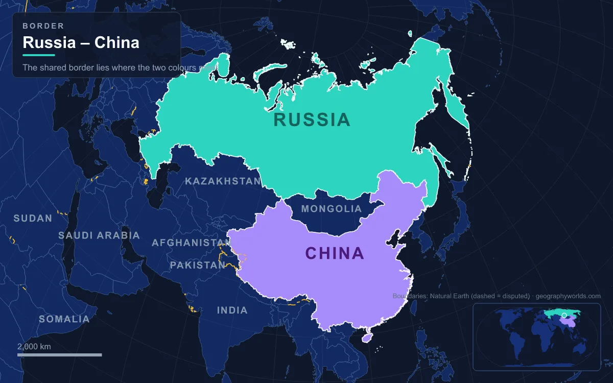
Mongolia splits the line in two. When the Soviet Union recognised Outer Mongolia in 1921, and China followed in 1946, the old Qing–Russian frontier lost its middle, leaving the two sections that exist today. What follows travels both of them, looking at the ground each one crosses and the people who live along it.
The Altai Section, Where No Road Crosses
The western section begins at the China–Kazakhstan–Russia tripoint, fixed by treaty at 3,327 metres, and ends at the summit of Tavan Bogd, a 4,374-metre peak where Mongolia joins in. In between lies high, glaciated country with no settlements on the line itself. Russian topographic maps give the lowest crossing points as the Kanas Pass at about 2,650 metres and the Betsu-Kanas Pass at about 2,671 metres, and neither carries a road fit for wheeled vehicles. Kazakh herders used these passes now and then until the Soviet authorities closed the border in 1936.
This stretch was the first to be settled after the Soviet collapse. Russia and China signed a demarcation agreement for it on 3 September 1994, and survey teams had finished marking it by 1998. There are plans for a road and for a gas pipeline across these mountains, but for now it is the one part of the frontier where the landscape does the guarding.
The Argun Steppe and the Three-River Country
The eastern section starts at the Tarbagan-Dakh monument, the eastern Mongolian tripoint, and heads north-east across open grassland to meet the Argun River. The Argun, known in its upper reaches in China as the Hailar, is 1,620 kilometres long, and for about 944 kilometres it is the border itself. That line goes back to the Treaty of Nerchinsk of 1689, the first formal treaty China ever signed with a Western power, which makes the Argun the oldest stretch of the present line.
The busiest land crossing is here. Manzhouli, on the Chinese side, grew up around a railway station on the Chinese Eastern Railway, completed in 1901 to link Siberia with Vladivostok across Manchuria. The town’s name comes from the Russian name of that station, and by 2010 it had almost 250,000 residents. Its Russian counterpart, Zabaykalsk, had just over 10,000 people at the 2002 census, a difference in scale you see again and again along the border.
North of Manzhouli, between the Greater Khingan forests and the river, lies the region Russian settlers called Tryokhrechye, the Three-River Country, after the Gan, Derbul and Khaul rivers that drain into the Argun. Russian gold panners moved in from the 1860s, and by 1907 there were about 1,000 Russian households in what is now the Ergun area. Their descendants are one reason Russians are one of China’s 56 officially recognised ethnic groups. There are more than 16,000 of them today, and the only ethnic township designated for them, Enhe Russian Ethnic Township, is on this stretch of the Argun.

Blagoveshchensk and Heihe on the Black Dragon River
Where the Shilka and the Argun meet, the Amur begins. Its Chinese name, Heilongjiang, means Black Dragon River, and the province on its south bank takes the same name. The Amur proper is 2,824 kilometres long, or 4,444 kilometres if you count the Argun as its upper course, which makes it the world’s tenth-longest river. It is home to the kaluga, a sturgeon that can grow to 5.6 metres. The Treaty of Aigun in 1858 made the river the border, moving the line south from the Stanovoy Mountains, where Nerchinsk had drawn it, and handing the whole left bank to Russia.
Blagoveshchensk and Heihe face each other directly across the river where the Zeya flows in. Blagoveshchensk began in 1856 as a military post called Ust-Zeysky and became the capital of Russia’s Amur region two years later. Heihe grew out of Aigun, the Qing garrison town where the 1858 treaty was signed. The river between them also holds one of the frontier’s darkest memories. In July 1900, during the Boxer Rebellion, Russian authorities in Blagoveshchensk forced the city’s Qing subjects into the Amur, and Chinese sources put the dead at about 5,000.
Today the two cities are connected by a road bridge. Building work started in 2016 and the structure was finished in 2019. Freight began crossing on 10 June 2022, cars followed on 2 January 2025, and by 2024 about 200 lorries a day were using it. At the 2020 census Heihe’s prefecture had 1,286,401 people, though fewer than a quarter of a million lived in the built-up city. Winters are severe on both banks: January in Heihe averages −22 °C, and temperatures have fallen as low as −44.5 °C.
Khabarovsk, Bolshoy Ussuriysky Island and the 2008 Handover
Downstream, the Amur meets the Ussuri beside Khabarovsk, the administrative centre of Khabarovsk Krai, with 617,441 people in 2021, about 30 kilometres from the line. At the confluence lies Bolshoy Ussuriysky Island, called Heixiazi, or Black Bear Island, in Chinese. It covers roughly 330 square kilometres of river silt. Soviet forces occupied it in 1929, and for most of the next 75 years it was the sharpest point of disagreement. With the whole island in Russian hands, Khabarovsk had a buffer and Moscow controlled the main channel. China, which never accepted the occupation, claimed the islands as part of its Fuyuan County.
The 2004 Complementary Agreement split the difference. Russia handed over Yinlong (Tarabarov) Island and about half of Bolshoy Ussuriysky, some 170 square kilometres, along with part of Abagaitu Islet on the Argun. In return, China dropped its claim to the rest. Both parliaments ratified the deal in 2005, and the transfer ceremony took place on the island on 14 October 2008, ending a dispute that had run since the Soviet occupation of 1929. The Chinese half now belongs to Fuyuan, China’s easternmost county, and the territory transferred was almost uninhabited.
The Nanai, the Ussuri and the Island of Damansky
The oldest communities on the border are Tungusic peoples who lived on both banks long before any treaty. The Nanai have traditionally fished and hunted along the Amur, the Ussuri and the Songhua. Russia counted 12,003 Nanai in 2010. China recognises the same people as the Hezhe, one of its 56 official ethnic groups, with 4,640 recorded in China’s most recent count, mostly in Heilongjiang. Their oral epics, the Yimakan, are sung in a dialect that has no written form in China. A border drawn down the middle of their rivers split one people between two states.
South of Khabarovsk the line follows the Ussuri, an 897-kilometre river that rises in the Sikhote-Alin range and was made the border by the Convention of Peking in 1860. That treaty gave Russia the land that is now Primorsky Krai and cut China off from the Sea of Japan. In March 1969 the Ussuri became a front line. Chinese and Soviet troops clashed on Zhenbao, or Damansky, Island, with dozens of casualties on each side, and further clashes followed that August in Xinjiang. The crisis cooled after Soviet Premier Alexei Kosygin met Zhou Enlai in Beijing on 11 September 1969. The border stayed heavily militarised until trade reopened in the 1980s, and between 1988 and 1992 cross-border commerce with Heilongjiang roughly tripled. Abandoned Soviet military posts still stand in Russia’s border districts.

Lake Khanka, Suifenhe and the Run to the Tumen
The last few hundred kilometres cross the lowlands of Primorye. The border runs across Lake Khanka, known in China as Xingkai, a shallow lake whose surface varies between about 3,940 and 5,010 square kilometres depending on the weather. Its average depth is only 4.5 metres. The northern part belongs to China, but 97 per cent of its catchment lies in Russia, and its one outflow, the Songacha, drains into the Ussuri.
Further south, the Chinese Eastern Railway crosses the line at Suifenhe, opposite the Russian town of Pogranichny. In January 2014 Suifenhe became the only city in China where trading in Russian roubles was officially allowed. The border then runs south-west to end on the Tumen River, at the tripoint with North Korea, a few kilometres before the river reaches the sea.
Everyday life along the whole line is set by a 2006 border-management treaty. It requires a 15-metre strip to be kept clear of trees, bans hunting with firearms within 1,000 metres of the line, and obliges each side to return livestock that wanders across. The people on the two banks are very unevenly matched. Russia’s entire Far Eastern Federal District has around 7.9 million residents spread over nearly 7 million square kilometres, while Heilongjiang alone had 30.99 million at the end of 2022. Russia is one of the 14 countries that border China, and its frontier with China is the one that Mongolia splits into two separate sections. The river at its heart is followed from source to sea in our guide to the Amur River, and you can see how it compares with Russia’s other land frontiers in the round-up of Russia’s neighbouring countries.