
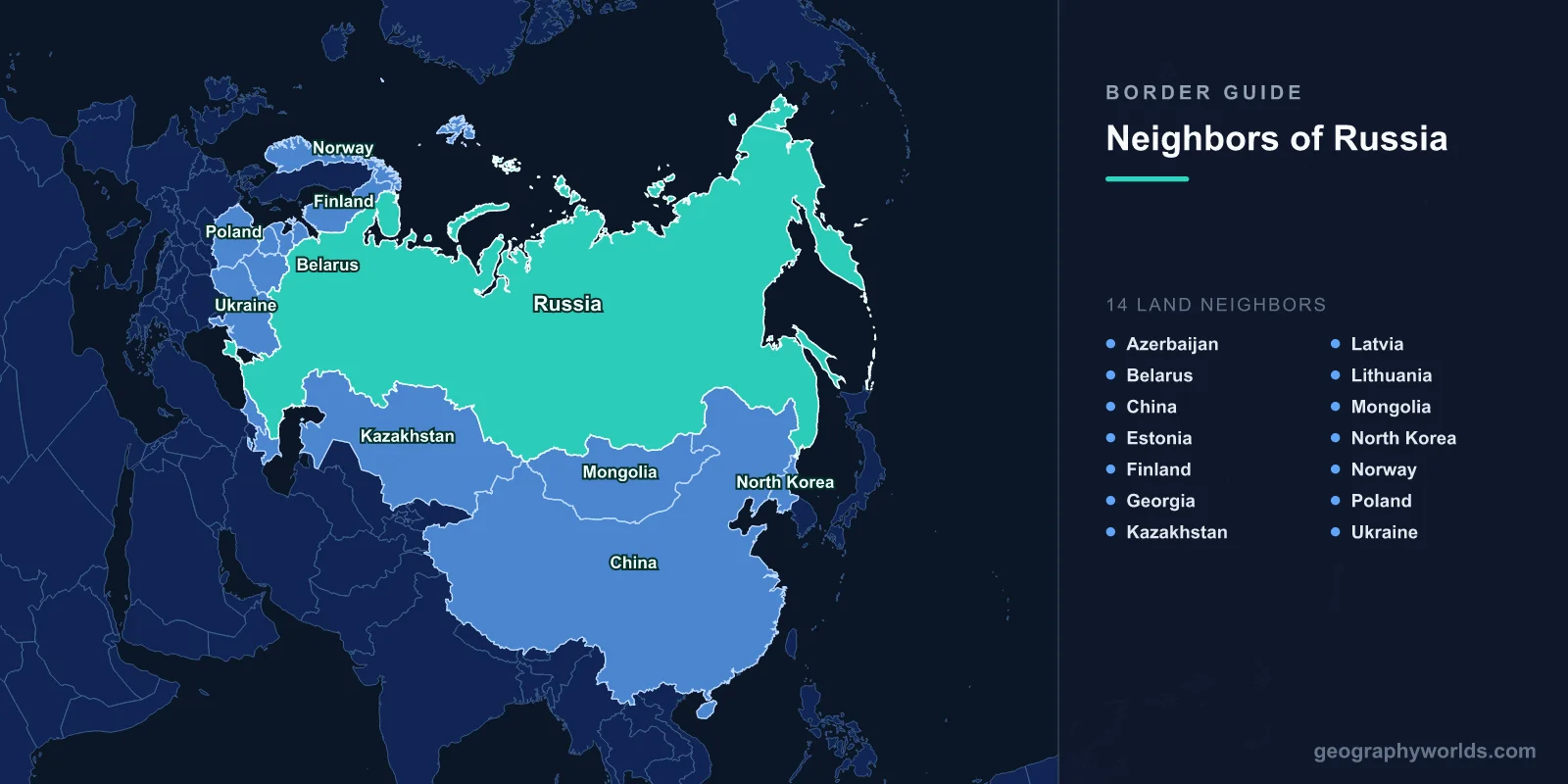
Russia borders 14 countries by land: Norway, Finland, Estonia, Latvia, Lithuania, Poland, Belarus, Ukraine, Georgia, Azerbaijan, Kazakhstan, Mongolia, China and North Korea. Those frontiers add up to about 22,400 km, the longest land boundary of any country, and only China matches its total of 14 neighbours. Russia also has sea borders with two countries it never touches by land, Japan and the United States. Two of the 14, Lithuania and Poland, border only the Kaliningrad exclave, not mainland Russia.
The shortest is 18 km of river shared with North Korea; the longest, with Kazakhstan, runs about 400 times that. Some are open roads with no passport check, and at least one is closed at every crossing. The clearest way to understand the ring is to travel it, starting at the Barents Sea and moving clockwise to the Sea of Japan.
All 14 Borders by Length
Figures are from the CIA World Factbook. Other sources differ by a few kilometres, because river borders can be measured along different channels.
| Neighbour | Border length | Where it runs |
|---|---|---|
| Kazakhstan | 7,644 km | Caspian Sea to the Altai |
| China | 4,179 km | Two separate stretches, split by Mongolia |
| Mongolia | 3,452 km | Altai to Transbaikalia |
| Ukraine | 1,944 km | Internationally recognised line, Sea of Azov to Belarus |
| Belarus | 1,312 km | Smolensk and Bryansk regions |
| Finland | 1,309 km | Gulf of Finland to the Arctic |
| Georgia | 894 km | Crest of the Greater Caucasus |
| Azerbaijan | 338 km | Eastern Caucasus to the Caspian |
| Latvia | 332 km | Pskov region |
| Estonia | 324 km | Narva River and Lake Peipus |
| Lithuania | 261 km | Kaliningrad only |
| Poland | 204 km | Kaliningrad only |
| Norway | 191 km | Pasvik River to the Barents Sea |
| North Korea | 18 km | Lower Tumen River |
The Arctic Start: Norway and Finland
Russia's shortest European border is with Norway: 191 km, most of it along the Pasvik River, with Storskog near Kirkenes as the only road crossing. The line in its current form dates from 1944, when the Soviet Union took Petsamo from Finland and with it Finland's corridor to the Arctic Ocean. The sea boundary took much longer. For four decades Oslo and Moscow disputed about 175,000 km² of the Barents Sea, until a treaty signed in Murmansk in September 2010 split the area roughly in half.
Finland's 1,309 km border is a different kind of frontier. It follows forest, lake and marsh from the Gulf of Finland almost to the Arctic, and the country behind it was shaped by the Winter War of 1939–40, when Finland lost Karelia and the city of Vyborg. Finland stayed militarily non-aligned for the rest of the century, then joined NATO on 4 April 2023 and more than doubled the alliance's land border with Russia. Late in 2023, after more than a thousand asylum seekers without visas were sent to its crossings, Finland closed all eight road crossings. In 2024 it extended the closure with no end date.
The Baltic States and the Kaliningrad Detour
Moving south, the border meets the three Baltic states, all Soviet republics until 1991. Estonia's 324 km runs mostly along the Narva River and Lake Peipus. At Narva, a Hermann Castle built under Danish and Teutonic Order rule faces Russia's Ivangorod fortress across a narrow stretch of river. A few kilometres south is the Saatse Boot, where an Estonian road crosses roughly a kilometre of Russian land and drivers are not allowed to stop. A border treaty was signed in 2005. Russia withdrew its signature after Estonia's parliament added a preamble citing the 1920 Treaty of Tartu. The treaty was signed again in 2014 and still has not been ratified.
Latvia's 332 km has an older loss behind it. In 1944 the Abrene district was transferred to the Russian SFSR and became Pytalovo. Latvia accepted that line when it signed a border treaty with Russia in March 2007, which is why the district now appears on no Latvian map.
Lithuania and Poland are on the list only because of Kaliningrad, the northern half of German East Prussia that was assigned to the Soviet Union in 1945. The city of Königsberg was renamed, its German population was expelled, and when Lithuania became independent in 1991 the region was left as a Russian exclave with no land connection to Russia. Rail freight to Moscow crosses Lithuania. When Vilnius applied EU sanctions to that transit in June 2022, it briefly became a diplomatic crisis. The land gap between Kaliningrad and Belarus, the Suwałki Gap along the Polish-Lithuanian border, is about 65 km wide and features in NATO planning. The full story of the exclave is in our guide to what Kaliningrad is and how Russia came to own it.
Belarus and Ukraine: An Open Road and a War
The 1,312 km border with Belarus is the one where borders almost stop meaning anything. Since the Union State treaty of December 1999 there have been no routine controls for Russian and Belarusian citizens. In February 2022, Russian forces used Belarusian territory to launch the northern thrust toward Kyiv.
Ukraine is the only one of the 14 where the border itself is disputed. The internationally recognised line is 1,944 km long. Russia annexed Crimea in 2014, opened the Kerch Strait bridge in 2018, and in September 2022 claimed four more Ukrainian regions: Donetsk, Luhansk, Zaporizhzhia and Kherson. The UN General Assembly rejected both annexations, so on almost every map outside Russia the border is where it was in 1991. On the ground, the line that matters is the front.
Across the Caucasus: Georgia and Azerbaijan
The border with Georgia runs 894 km along the crest of the Greater Caucasus, with peaks above 5,000 m. The only regularly used road crossing is Upper Lars, where the Georgian Military Road goes through the Darial Gorge. In September 2022 it was jammed with Russian men leaving to avoid mobilisation.
The 14-country count leaves out a complication. After the 2008 war, Russia recognised Abkhazia and South Ossetia as independent states. Moscow therefore describes borders with both, which gives it 16 neighbours on its own count. Almost no one else accepts that: only a handful of UN members recognise either territory, and every standard reference counts both as part of Georgia. Russian troops remain in both. Along the South Ossetian line, fences and markers have been moved deeper into Georgian-held land several times since 2008, a process Georgians call "borderisation".
Azerbaijan's 338 km, where the mountains drop to the Caspian, follows much of the Samur River. The river splits the Lezgin people between Dagestan on the Russian side and northern Azerbaijan, and the Yalama crossing carries most of the road traffic between Russia and the South Caucasus.
Kazakhstan: The Longest Continuous Border on Earth
At 7,644 km, the border with Kazakhstan is the world's longest continuous land border. The US-Canada boundary is longer in total but comes in two pieces, split by Alaska. The Kazakh line runs from the Caspian coast near Atyrau across the steppe to the Altai mountains, mostly across open grassland.
The Ural River crosses the border and is conventionally taken as a boundary between Europe and Asia, so a small part of Kazakhstan counts as European. Several million ethnic Russians live in the northern provinces along the border, which is one reason Kazakhstan moved its capital north from Almaty to Astana in 1997. Russia also still leases the Baikonur Cosmodrome from Kazakhstan, on terms that run to 2050. Our guide to the countries that border Kazakhstan covers the line from the other side.
Mongolia and China: A River Line Settled in 2008
Mongolia's 3,452 km border goes through the Altai, the Tuva highlands and the Selenga basin, which drains into Lake Baikal. Tuva was itself a nominally independent state, the Tuvan People's Republic, from 1921 until the Soviet Union absorbed it in 1944.
China appears on both sides of Mongolia. A short western stretch of about 50 km crosses the Altai between Kazakhstan and Mongolia. The long eastern stretch follows the Argun, Amur and Ussuri rivers down toward the Pacific. That river line comes from the treaties of Aigun (1858) and Peking (1860), in which a weakened Qing China gave up Outer Manchuria, including the coast where Vladivostok now stands. Beijing later called these the "unequal treaties", and in March 1969 Soviet and Chinese troops fought over Zhenbao, or Damansky, Island in the Ussuri. A final agreement in 2004 gave China Tarabarov Island and about half of Bolshoy Ussuriysky Island, and demarcation was completed in 2008. We cover this history in more detail in the Russia-China border guide.
Eighteen Kilometres of North Korea
The last land border, and the shortest, is 18 km along the lower Tumen River just before it reaches the Sea of Japan. The Friendship Bridge, a rail bridge opened in 1959, links Khasan in Russia with Tumangang in North Korea. Work on a road bridge alongside it began in 2025. This short stretch also means China does not reach the Sea of Japan. The Chinese border stops about 15 km upstream, so Chinese ships leaving the Tumen have to pass between Russian and North Korean banks.
Neighbours Across Water: Japan and the United States
Russia shares no land with Japan or the United States, but both are close. The La Pérouse Strait between Sakhalin and Hokkaido is about 42 km wide. The southern Kuril Islands, which Japan calls the Northern Territories and has claimed since the Soviet Union seized them at the end of the Second World War, are the reason the two countries have never signed a peace treaty ending the Second World War.
In the Bering Strait, Russia's Big Diomede and America's Little Diomede are 3.8 km apart, with the International Date Line between them. Their clocks differ by 21 hours, or 20 when Alaska is on daylight time. The maritime line in the Bering Sea was agreed by the Soviet Union and the United States in 1990. The US ratified it; Russia never has, but has followed it ever since.
Why the List Changed in 1991
The Soviet Union had 12 land neighbours: Norway, Finland, Poland, Czechoslovakia, Hungary, Romania, Turkey, Iran, Afghanistan, China, Mongolia and North Korea. When it broke up, Russia lost six of them in one step, including every southern neighbour from Turkey to Afghanistan. It gained eight new ones among the former republics, from Estonia to Kazakhstan. Only Norway, Finland, Poland, China, Mongolia and North Korea have been Moscow's neighbours throughout.
That is why the total is so high. The size of Russia sets the length of the border, but most of the 14 exist because the borders between former Soviet republics became international borders overnight. For how Russia compares with China, Brazil and the rest of the top of the table, see our ranking of the countries with the most land borders, where Russia and China share first place.