
A panhandle is a narrow strip of territory extending from a larger body, creating a shape resembling the handle of a pan. These geographic oddities appear on every continent, each one the product of a specific historical negotiation, colonial compromise, or strategic calculation. Far from being mere cartographic curiosities, panhandles often carry outsized political and military significance.
Introduction
From Afghanistan's Wakhan Corridor — a finger of land that kept the British and Russian Empires apart — to Namibia's Caprivi Strip, which gave a landlocked colony access to a river, these elongated territories reveal the hidden logic of borders. They are living artifacts of deals struck by diplomats, surveyors, and colonial administrators whose decisions continue to shape the map.
The Wakhan Corridor, Afghanistan
- Length: ~350 km
- Width: 13–65 km
- Purpose: Buffer between British and Russian empires
- Created: 1893 (Durand Line agreement)
The Wakhan Corridor is one of the most dramatic panhandles on Earth — a narrow finger of Afghan territory stretching approximately 350 kilometers eastward between Tajikistan to the north and Pakistan to the south, narrowing to just 13 kilometers at its thinnest point before reaching a short 76-kilometer border with China. This strip exists solely as a product of the Great Game, the 19th-century rivalry between the British and Russian empires.
Both empires agreed that a buffer of Afghan territory should separate Russian Central Asia from British India, preventing direct confrontation. The Wakhan Corridor served this purpose perfectly. Today it remains one of the most remote and inaccessible regions in the world, home to roughly 12,000 Wakhi and Kyrgyz people who live in extreme isolation at altitudes above 3,000 meters, reachable only by unpaved mountain tracks.
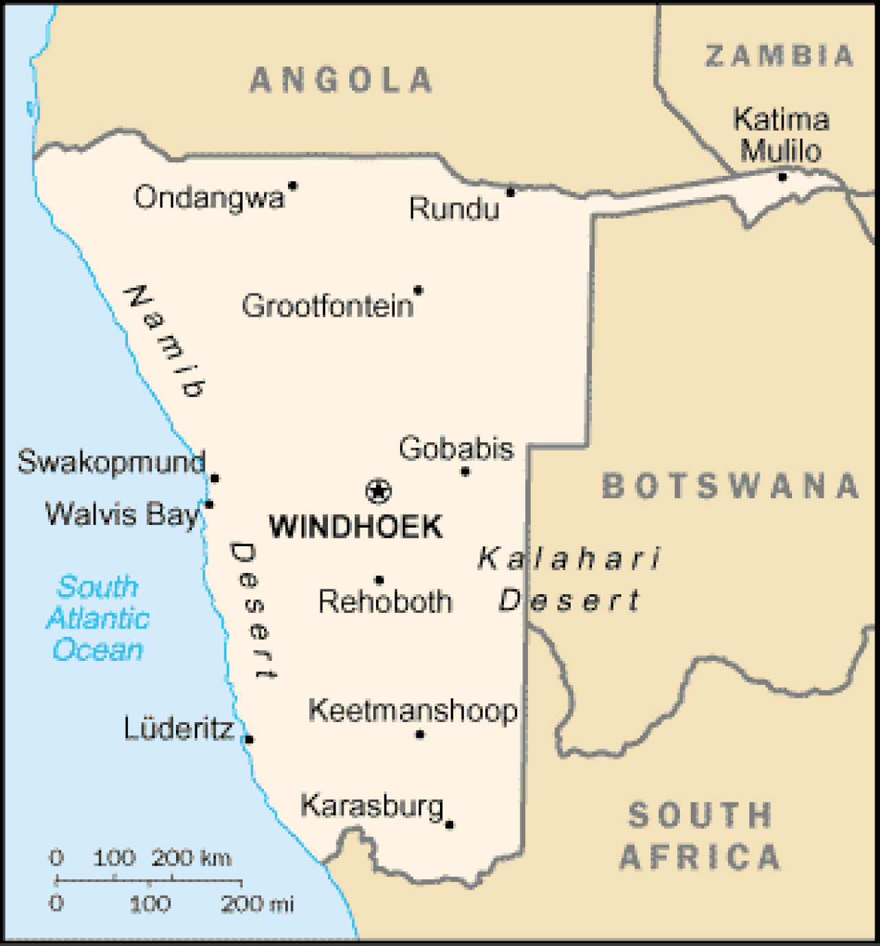
The Caprivi Strip, Namibia
- Length: ~450 km
- Width: ~32 km
- Purpose: Access to the Zambezi River
- Created: 1890 (Heligoland-Zanzibar Treaty)
The Caprivi Strip (now called the Zambezi Region) is a narrow panhandle extending approximately 450 kilometers eastward from northeastern Namibia, giving the country access to the Zambezi River. This peculiar shape was created by the 1890 Heligoland-Zanzibar Treaty between Germany and Britain, in which Germany gained this corridor for its colony of South-West Africa in exchange for ceding Zanzibar.
Germany believed the strip would provide a water route to its East African colony (now Tanzania) via the Zambezi. They did not realize that Victoria Falls — entirely unnavigable — blocked this route. The strip has been a source of instability, with a brief separatist uprising in 1999. Today it is a wildlife corridor connecting several national parks, and its wetlands are home to elephants, hippos, and crocodiles.
The Oklahoma Panhandle, USA
- Length: ~270 km
- Width: ~56 km
- Nickname: No Man's Land
- Created: 1850 Compromise and subsequent boundary changes
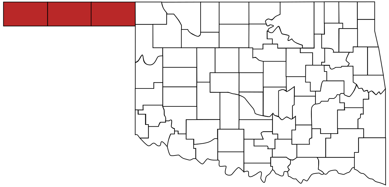
The Oklahoma Panhandle is a rectangular strip of territory approximately 270 kilometers long and 56 kilometers wide, extending westward from the main body of the state. It exists because of a quirk of American slavery politics. When Texas was admitted to the Union in 1845, it was forced to cede its territory above the 36°30' parallel (the Missouri Compromise line) to remain a slave state. This created an orphaned strip that belonged to no state or territory.
For nearly 40 years, this "No Man's Land" had no formal government. Settlers established their own provisional territory called Cimarron Territory, but it was never recognized by Congress. The strip was finally attached to Oklahoma Territory in 1890. Today it is one of the least populated areas of the United States, with vast cattle ranches and wheat farms stretching across the flat High Plains.
Other Notable Panhandles
- Florida Panhandle: ~350 km, northwestern extension toward Alabama
- Chicken Neck (Siliguri Corridor): India, ~22 km wide, connects northeast India
- Democratic Republic of Congo: Copper-rich Katanga panhandle extends south
India's Siliguri Corridor, nicknamed the "Chicken's Neck," is one of the most strategically significant panhandles in the world. This strip of Indian territory narrows to just 22 kilometers between Nepal, Bangladesh, and Bhutan, serving as the sole land connection between India's seven northeastern states and the rest of the country. Over 50 million people depend on this narrow corridor for access to mainland India, making it a critical vulnerability in Indian defense planning.
The Democratic Republic of Congo's southeastern panhandle extends deep into Zambia, encompassing the mineral-rich Katanga (now Haut-Katanga) province. This extension was no accident — Belgian colonial administrators insisted on including the copper belt within their colony. Katanga attempted to secede in 1960, triggering a crisis that drew in UN peacekeepers and Cold War powers, partly because its panhandle shape made it geographically separable from the rest of the country.
Why Panhandles Persist
- Legal Inertia: Borders are extremely difficult to change once established
- Strategic Value: Many serve as corridors or buffer zones
- Identity: Residents often develop distinct regional identities
Once established, panhandles rarely disappear. International law strongly favors the status quo in border matters, and changing borders requires consent from all parties — a condition that is almost never met because the country losing territory has no incentive to agree. Even domestic panhandles like Florida's and Idaho's persist because redrawing state or provincial lines would be constitutionally complex.
Many panhandles serve ongoing strategic purposes. The Wakhan Corridor still buffers potential rivals. The Siliguri Corridor remains India's lifeline to its northeast. Namibia's Zambezi Region provides access to southern African river systems. The residents of panhandles often develop distinct identities — Floridians in the panhandle identify more with the Deep South than with Miami, and the Caprivi Strip was home to a separatist movement with its own cultural identity.
Key Facts
- Afghanistan's Wakhan Corridor stretches 350 km and narrows to just 13 km — created as a buffer between empires
- Namibia's Caprivi Strip (450 km long) was traded for Zanzibar in 1890 — but Victoria Falls blocked its intended purpose
- The Oklahoma Panhandle was "No Man's Land" for 40 years due to American slavery politics
- India's Siliguri Corridor is only 22 km wide, connecting 50+ million people in the northeast to mainland India
- Panhandles persist due to legal inertia — borders are extremely difficult to change once established
Fun Facts
- Germany traded Zanzibar for the Caprivi Strip without realizing Victoria Falls made the river route useless
- The Oklahoma Panhandle once had its own unofficial government called the Cimarron Territory
- Afghanistan's Wakhan Corridor has no paved roads and is cut off by snow for much of the winter
- Florida's panhandle is in a different time zone from the rest of the state
Final Thoughts
Panhandles are geography's reminders that borders are not drawn by nature but by negotiation, accident, and ambition. These long, narrow strips of territory tell stories of empires jockeying for position, diplomats trading land like chess pieces, and communities developing unique identities in the geographic margins. They challenge the assumption that nations should be compact and contiguous, proving that political geography is anything but tidy.
Test Your Knowledge!
Think you know the world's borders? Try our interactive geography quiz!
Play Neighbor Quiz →