
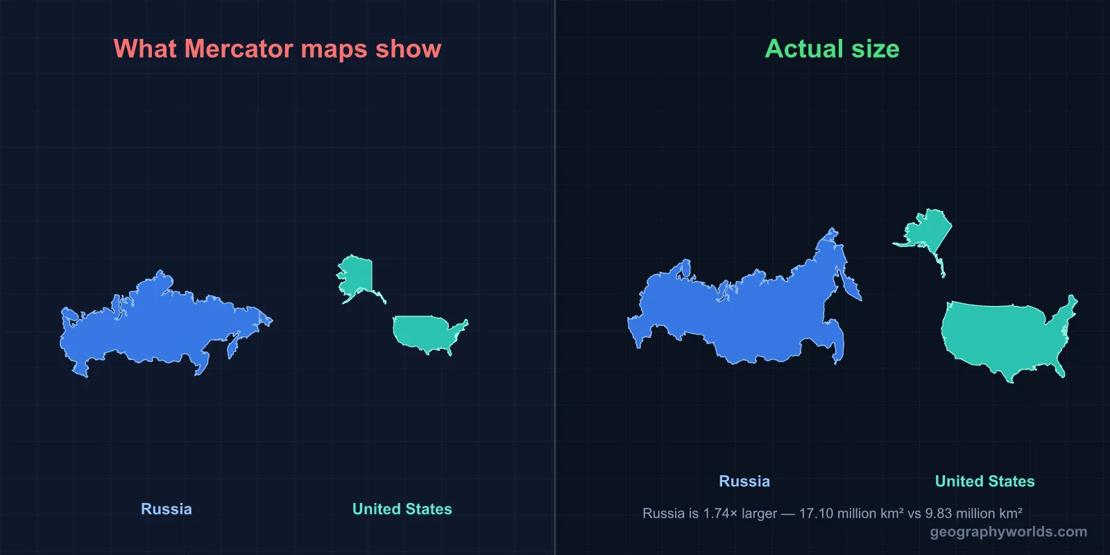
Russia is about 1.7 times the size of the United States (roughly 17.1 million km² against 9.8 million km²), but the United States has well over twice as many people (about 340 million against roughly 146 million) and an economy around ten times larger in nominal terms. The two countries are also neighbours: across the Bering Strait, Russian and American islands lie less than 4 km apart.
Four Kilometres Apart: The Diomede Islands
The best place to start comparing these two countries is the Bering Strait, where they almost touch. It is about 82 km wide at its narrowest, between Cape Dezhnev on Russia's Chukotka Peninsula and Cape Prince of Wales in Alaska. Halfway across sit the two Diomede Islands: Big Diomede (Ratmanov Island), which belongs to Russia, and Little Diomede, which belongs to the United States. Roughly 3.8 km of water separates them.
The international boundary and the International Date Line run down that channel together. Big Diomede keeps Kamchatka time (UTC+12) and Little Diomede keeps Alaska time (UTC−9), so in winter the clocks on the two islands are 21 hours apart, and the Russian island is already living in tomorrow.
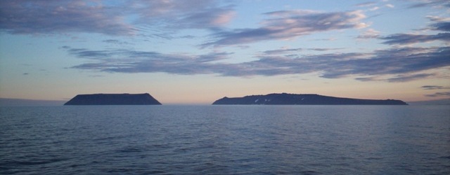
Little Diomede has an Iñupiat village of fewer than 100 people. Big Diomede has no civilian population: its residents were moved to the Siberian mainland after the Second World War, and the island became a Soviet border post on what Alaskans called the Ice Curtain. On 7 August 1987 the American swimmer Lynne Cox swam from Little to Big Diomede in water of about 4 °C, and both Ronald Reagan and Mikhail Gorbachev praised the swim at the signing of the INF Treaty that December. Visa-free visits for Indigenous residents of Chukotka and Alaska followed in 1989. The Bering Strait is also where the Pacific meets the Arctic Ocean.
How Alaska Changed Flags in 1867
The two countries are neighbours here because Alaska used to be Russian. Russian fur traders reached the Aleutian Islands in the 1740s, after Vitus Bering's expedition of 1741, and the Russian-American Company ran the colony from its capital at Novo-Arkhangelsk, today's Sitka.
By the 1860s the colony was losing money, the sea otter trade had collapsed, and Russia, weakened by the Crimean War, feared it could not defend Alaska against Britain. On 30 March 1867 the US Secretary of State William Seward and the Russian envoy Eduard de Stoeckl signed a treaty selling about 1.5 million km² for $7.2 million, roughly two cents an acre. The Senate ratified it 37 to 2, and the flag was changed at Sitka on 18 October 1867. Newspapers mocked the deal as "Seward's Folly" until the Klondike and Nome gold rushes of the 1890s, and later the Prudhoe Bay oil field, showed what had been bought. The geography of the Alaska Purchase still shapes the map: without Alaska the United States would be smaller than Brazil.
Russia vs the United States on the Map: Area, Borders and Clocks
Russia covers about 17.1 million km², around one-eighth of the world's land and almost twice the area of any other country. It stretches about 9,000 km from the Baltic exclave of Kaliningrad to the Bering Strait and is divided into 11 time zones, from UTC+2 in Kaliningrad to UTC+12 in Kamchatka and Chukotka.
The United States covers about 9.8 million km² including its lakes, rivers and coastal waters, third or fourth in the world depending on how China is measured. The 50 states use six standard time zones: Eastern, Central, Mountain, Pacific, Alaska and Hawaii-Aleutian. Federal law defines nine in total once the Atlantic zone of Puerto Rico and the US Virgin Islands, Samoa time and Chamorro time on Guam are added, and the count reaches 11 if uninhabited Pacific islands such as Wake and Baker are included.
Borders separate the two countries even more than area does. Russia shares land borders with 14 countries, from Norway and Finland in the northwest to China, Mongolia and North Korea in the east; its border with Kazakhstan, at about 7,500 km, is one of the longest continuous land borders in the world. The United States has two land neighbours, Canada and Mexico, and its frontier with Canada, about 8,900 km including the Alaska section, is the longest international border on Earth.
Where 146 Million and 340 Million People Live
The population figures need a caveat. Rosstat, Russia's statistics office, put the population at about 146 million at the start of 2025. That total includes Crimea and Sevastopol, annexed from Ukraine in 2014 and not recognised as Russian by most countries; without them the figure is about 144 million. The US Census Bureau estimated about 340 million people in mid-2024. The US population is growing, mostly through immigration; Russia's has been flat or shrinking since the 1990s.
Put the two together and Russia has roughly 9 people per km², against about 35 in the United States. In Russia, about three-quarters of the people live west of the Ural Mountains, in the European part, which is only about a quarter of the territory. Siberia and the Far East, three-quarters of the land, hold less than a fifth of the people. Moscow, with about 13 million inside the city limits, is by far the largest city, followed by Saint Petersburg at about 5.6 million.
The United States is more evenly spread. Its people live along both coasts, around the Great Lakes and across the fast-growing South, and no single city dominates the way Moscow does. The empty parts of America are the Great Basin, the northern Great Plains and Alaska, which has about 740,000 people in an area larger than Texas, California and Montana combined.
Oil, Gas and Wheat: Resource Giants of Unequal Wealth
The United States has been the world's largest crude oil producer since 2018, thanks to shale fields in Texas, New Mexico and North Dakota, and it is also the largest producer of natural gas. Russia is second in gas and among the top three in oil, with most of its output coming from Western Siberia. It holds the world's largest proven gas reserves, much of them on the Yamal Peninsula.
Wheat shows the same rivalry. Russia's black-earth (chernozem) belt, running from the Ukrainian border to southern Siberia, made it the world's largest wheat exporter, shipping roughly a fifth of all wheat traded internationally in recent seasons, mostly through Black Sea ports such as Novorossiysk. The United States grows less wheat than Russia but far more maize and soybeans.
Where they differ most is in what the resources add up to. US nominal GDP was about $29 trillion in 2024; Russia's was a little over $2 trillion, so the American economy is roughly ten to fourteen times larger depending on the exchange rate used. The gap narrows sharply at purchasing power parity, because prices in Russia are much lower, but it remains large. Russia's economy leans heavily on oil, gas and metals; America's is dominated by services and technology.
Oymyakon to Death Valley: The Temperature Range
Russia is mostly a cold country. Permafrost lies under roughly 60 to 65 percent of its territory, and the villages of Oymyakon and Verkhoyansk in Yakutia compete for the title of coldest permanently inhabited place on Earth. Verkhoyansk recorded −67.8 °C in February 1892 and Oymyakon −67.7 °C in February 1933. Yet Verkhoyansk also reached 38 °C on 20 June 2020, which the World Meteorological Organization accepted as the highest temperature recorded in the Arctic.

The United States reaches further south, into the subtropics. Death Valley in California holds the official world record of 56.7 °C, set at Furnace Creek on 10 July 1913, although some climatologists doubt that reading. Florida, southern Texas and Hawaii have tropical or subtropical climates that Russia has nowhere. The two countries meet at the cold end of their ranges: Alaska's record low, −62.1 °C at Prospect Creek in January 1971, is close to Siberian levels, and most of Alaska lies on permafrost too. More on Russia's climate zones, from tundra to steppe, is in our guide to the climate of Russia.
Fifty States and 83 (or 89) Federal Subjects
Both countries are federations with a directly elected president, and their upper houses look alike on paper: the US Senate has two senators from each state, and Russia's Federation Council has two members from each federal subject. The resemblance ends there: US states have their own constitutions and broad lawmaking powers, while Russia's regions have been steadily centralised since 2000.
The United States has 50 states, the federal District of Columbia and five inhabited territories, including Puerto Rico and Guam. Internationally recognised Russia has 83 federal subjects: 21 republics, 9 krais, 46 oblasts, 2 federal cities (Moscow and Saint Petersburg), the Jewish Autonomous Oblast and 4 autonomous okrugs. Russia itself counts 89, adding Crimea and Sevastopol (annexed in 2014) and the Donetsk, Luhansk, Zaporizhzhia and Kherson regions of Ukraine, which it claimed in September 2022 without fully controlling them. The UN General Assembly has rejected both annexations. The republics, such as Tatarstan, Chechnya and Sakha, are based on non-Russian ethnic groups and have their own official languages next to Russian, a layer of ethnic federalism the American system does not have. For the full list and how each type differs, see how many states Russia has.