
An estuary is a partly enclosed coastal body of water that has a free connection to the open sea and in which seawater is measurably diluted by freshwater draining off the land. That mixing produces brackish water — saltier than a river, fresher than the ocean — and it is the reason estuaries rank among the most biologically productive environments on the planet.
What separates an estuary from an ordinary river mouth
Not every place where a river reaches the sea is an estuary. Three conditions have to hold together. The water body must be semi-enclosed, so that it is sheltered enough for river and sea water to interact rather than being immediately dispersed by open-ocean waves. It must have a free connection to the sea, which rules out lakes and fully barred lagoons. And there must be measurable dilution of seawater by land drainage, which rules out inlets fed by no significant river.
Salinity is the practical test. Open ocean water sits at roughly 35 parts per thousand of dissolved salt. Fresh river water is close to zero. Estuarine water falls somewhere between, typically in the range of about 0.5 to 30 parts per thousand, and — critically — that value moves. It shifts with the tide, with the season, and with how much rain has fallen upstream. Organisms living in an estuary are not adapted to one salinity; they are adapted to constant change.
How estuaries form
The overwhelming majority of the world's estuaries are geologically very young — most are only about 10,000 to 12,000 years old, which is nothing on a geological timescale. They are a direct product of the end of the last Ice Age.
At the height of the last glacial maximum, enormous volumes of water were locked up in ice sheets and global sea level stood roughly 120 metres lower than today. Rivers had cut their valleys down to that much lower base level. As the ice sheets melted and sea level rose, the ocean advanced inland and drowned those existing valleys, flooding them from the seaward end. What had been a river valley became an arm of the sea with a river still flowing into its head.
This also explains why estuaries are, in geological terms, temporary. Rivers deliver sediment into them continuously, and unless sea level keeps rising or the land keeps subsiding, an estuary slowly fills in. Given enough time and enough sediment, an estuary becomes a delta, then a coastal plain.
The four main types of estuary
Estuaries are conventionally classified by the geological process that created the basin:
- Coastal plain (drowned river valley) — the most common type worldwide, formed exactly as described above. Chesapeake Bay and Delaware Bay are textbook examples; Chesapeake Bay is the drowned lower valley of the Susquehanna River.
- Bar-built — formed where sandbars or barrier islands build up parallel to a shoreline, partially enclosing a shallow body of water behind them. These are typically shallow, and their connection to the sea can be narrow enough that it shifts during storms. Albemarle and Pamlico Sounds behind North Carolina's Outer Banks are classic cases.
- Fjord-type — a valley gouged deep by a glacier, then flooded by rising sea level. These are dramatically deep and often have a shallow rocky sill at the mouth, which restricts exchange with the open ocean and can leave the deep water poorly flushed. Puget Sound and many Norwegian inlets fall into this group.
- Tectonic — the rarest type, formed where faulting, folding or land subsidence created a coastal depression that the sea later filled. San Francisco Bay is the standard example.
Salt wedges, mixing, and the mud that will not settle
Saltwater is denser than freshwater, so the two do not simply blend on contact. In many estuaries seawater pushes upstream along the bottom as a wedge, while lighter river water slides seaward over the top of it. Where the tidal range is small and river flow is strong — the lower Mississippi is the classic case — that salt wedge stays remarkably distinct, with an abrupt boundary between fresh water above and salt water below.
Where tides are stronger, turbulence blurs the boundary. Partially mixed estuaries such as Chesapeake Bay show a gradient rather than a sharp interface, and well-mixed estuaries — shallow, with strong tides — can be close to uniform from surface to bed. The two-layer flow this sets up is called estuarine circulation, and it is why estuaries act as sediment traps.
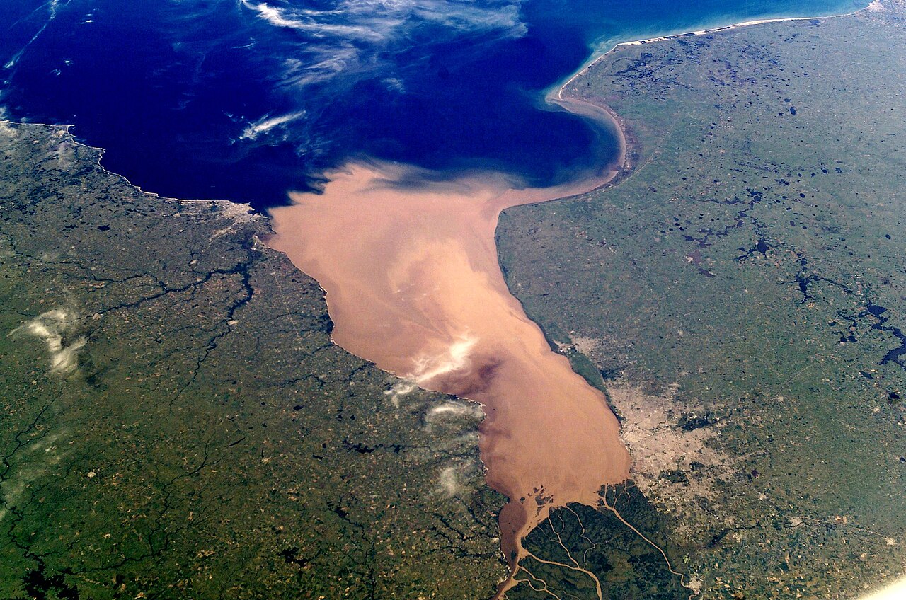
That trapping produces one of the most characteristic estuarine phenomena: the turbidity maximum. Fine clay particles carried down by a river are electrically charged and stay suspended in freshwater. When they meet saltwater, the dissolved ions neutralise those charges, the particles clump together — a process called flocculation — and the resulting aggregates become heavy enough to sink. The result is a persistent zone of murky, sediment-laden water partway up the estuary. Many estuaries look permanently muddy for exactly this reason, and it is a sign of a working system, not a polluted one.
Why estuaries are so productive
Estuaries generate more organic matter per unit area than almost any other ecosystem, including most farmland and much of the open ocean. Several factors compound:
- Nutrient delivery. Rivers carry nitrogen, phosphorus and silica from an entire drainage basin and concentrate them in a small area.
- Nutrient retention. Estuarine circulation recycles nutrients rather than flushing them straight to sea, so they are used repeatedly.
- Shallow, sunlit water. Light reaches the bed over much of the area, supporting seagrass beds and bottom-dwelling algae as well as plankton.
- Physical shelter. Marsh grass, mangrove roots and oyster reefs create structurally complex habitat where juvenile fish can hide from larger predators.
The result is that estuaries function as nurseries far out of proportion to their size. A very large share of commercially harvested fish and shellfish — often quoted at around three-quarters of the US catch — depends on estuarine habitat at some point in the life cycle, even for species that spend adulthood in the open ocean. Estuaries also filter water flowing to the sea, trapping sediment and absorbing excess nutrients, and their vegetation absorbs wave energy, buffering the coast behind them against storm surge.
Those same qualities make estuaries vulnerable. They sit at the bottom of entire river basins, so every pollutant, fertiliser runoff and sediment load from upstream ends up concentrated in them. Excess nitrogen in particular drives algal blooms that decay and strip oxygen from bottom water, producing the seasonal dead zones familiar in Chesapeake Bay and the northern Gulf of Mexico.
Estuary vs delta, lagoon and fjord
These four terms overlap enough to cause genuine confusion, and the distinctions are worth getting right because they describe opposite processes.
An estuary versus a delta is the clearest contrast. An estuary is a drowned feature: the sea has invaded the land faster than sediment can fill the space. A delta is a built feature: the river delivers sediment faster than waves and tides can carry it away, so land advances into the sea. The same river mouth can flip between the two states as sea level or sediment supply changes, and some large rivers show both — a delta plain that grades seaward into estuarine channels.
A lagoon is defined by its barrier rather than by mixing. It is a shallow body of water separated from the sea by a reef, sand spit or barrier island. Many lagoons are estuaries, because a river feeds them; many are not, because no significant freshwater enters. Some are actually saltier than the sea, where evaporation exceeds inflow.
A fjord is a landform description — a deep, steep-sided, glacially carved inlet — and says nothing about salinity. A fjord fed by meltwater rivers is an estuary; a fjord with no meaningful river input is simply a marine inlet. Similarly, an inlet is a general term for any narrow opening from the sea into the land, with no implication about freshwater mixing at all.
Notable estuaries around the world
- Chesapeake Bay, United States — the largest estuary in the US at roughly 320 km long, with a tidal shoreline running to many thousands of kilometres once all its tributaries are counted.
- Río de la Plata, Argentina and Uruguay — formed by the Paraná and Uruguay rivers and around 220 km across at its mouth, among the widest in the world.
- Sundarbans, India and Bangladesh — the Ganges–Brahmaputra–Meghna system, holding the largest mangrove forest on Earth and the last significant tiger habitat in a wetland.
- Thames Estuary, United Kingdom — heavily engineered, once considered biologically dead, and now a widely cited example of successful estuarine recovery.
- San Francisco Bay, United States — the best-known tectonic estuary, fed by the Sacramento and San Joaquin rivers.
Frequently asked questions
Is estuary water salty or fresh?
Neither — it is brackish, and it varies. Salinity generally increases toward the sea and decreases toward the river, and at any single point it rises and falls with each tide and with seasonal river flow.
Is every river mouth an estuary?
No. A river discharging directly onto an exposed open coast with no sheltering embayment is not an estuary, and neither is a delta channel where freshwater dominates all the way to the sea.
Where does the word come from?
From the Latin aestuarium, meaning a tidal inlet, derived from aestus — "tide," or "surging heat." The name captures the essential feature: an estuary is a place governed by tides.
Why does estuary water often look brown?
Because of flocculation. Fine clay particles clump and settle where fresh water meets salt, creating a persistent turbidity maximum. In most estuaries this is natural sediment, not pollution.