
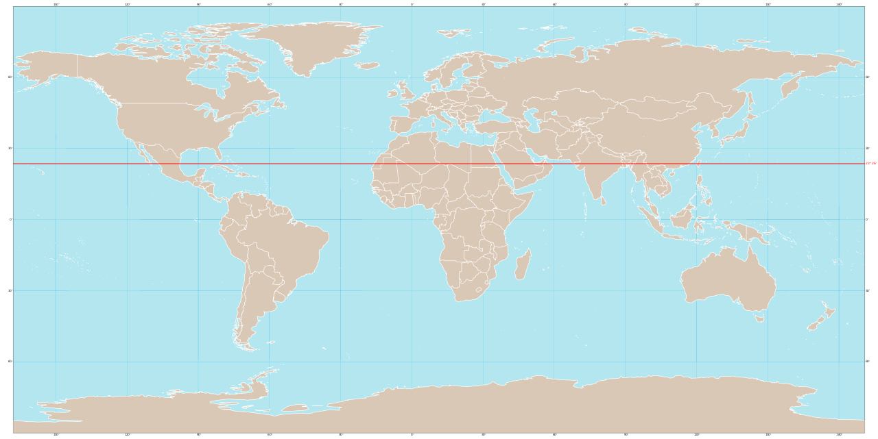
The Tropic of Cancer is one of the five major lines of latitude that define Earth's climate zones. Together with the Tropic of Capricorn, it marks the boundary of the tropics — the region of Earth where the Sun can be directly overhead at noon. Once a year, on the June solstice, the Sun stands directly above this line. The Tropic of Cancer crosses some of the world's most populous and culturally significant regions.
The Short Answer
The Tropic of Cancer is the imaginary line at 23.5° north latitude (23°27′N). It marks the northernmost point on Earth where the Sun is directly overhead at noon — specifically at the June solstice. North of this line, the Sun is never directly overhead. The line also marks the northern boundary of the geographic tropics, distinguishing tropical climate zones from subtropical ones.
The Geography
The Tropic of Cancer passes through:
- Africa: Western Sahara, Mauritania, Mali, Algeria, Niger, Libya, Egypt.
- Asia: Saudi Arabia, UAE, Oman, India, Bangladesh, Myanmar, China, Taiwan.
- Americas: Mexico, Bahamas, Cuba.
- Ocean crossings: Atlantic, Pacific.
- 16 countries cross the line
Why 23.5°N
The astronomical basis:
- Earth's rotational axis is tilted 23.5° from perpendicular to its orbit
- This tilt creates seasons
- At the June solstice, the Sun reaches its northernmost point
- That northernmost point is the Tropic of Cancer
- From there, the Sun appears to move south again
- 23.5° is the maximum northward solar declination
The Name
Why "Cancer"?
- In ancient times, the Sun was in constellation Cancer at the June solstice
- Greek and Roman astronomers established this naming
- Due to Earth's axial precession, this is no longer true
- The Sun is now in Taurus at the June solstice
- But the name remains by tradition
- Similarly, the Tropic of Capricorn is named for that constellation
The Summer Solstice
What happens on June 21:
- Sun appears directly overhead at Tropic of Cancer at solar noon
- Northern Hemisphere has longest day
- Sun never rises in Antarctic Circle
- Sun never sets in Arctic Circle
- Marks beginning of astronomical summer in Northern Hemisphere
- Major cultural significance for many traditions
The Tropics
The region between the Tropics:
- Between Tropic of Cancer (23.5°N) and Tropic of Capricorn (23.5°S)
- Sun is directly overhead at some point during the year
- About 40% of Earth's surface
- Includes much of Africa, South America, Southeast Asia
- Climate generally warmer year-round
- Less seasonal variation
Climate Along the Line
Regions vary widely:
- Western Sahara to Egypt: Extreme desert.
- Arabian Peninsula: Hot desert.
- India: Monsoon climates.
- Bangladesh, Myanmar: Tropical.
- China: Subtropical/tropical (Hong Kong area).
- Mexico: Varied.
- Cuba: Tropical.
Sahara Desert Connection
The Tropic of Cancer crosses through:
- The world's largest hot desert (Sahara)
- Subtropical descending air zone creates deserts
- Hot air rising at equator descends at ~23.5° latitude
- This descending air is dry — creates desert belts
- Sahara, Arabian, Mexican, US southwest deserts all related
- "Horse latitudes" — historic sailing region
The Tropic of Capricorn
The southern counterpart:
- Located at 23.5°S
- Mirror of Tropic of Cancer
- Sun directly overhead at December solstice
- Crosses South America, Africa, Australia
- Creates similar climate effects in Southern Hemisphere
Notable Locations
- Cairo, Egypt: Just north of the line.
- Karachi, Pakistan: Near the line.
- Kolkata, India: Just north.
- Dhaka, Bangladesh: Near the line.
- Hong Kong: Just south.
- Havana, Cuba: Just south.
- Mexico City: Just south.
Climate Patterns
How the line affects climate:
- Marks transition between tropical and subtropical climates
- Above the line: more seasonal variation
- Below: less seasonal variation
- Many desert regions just above
- Tropical rain belts near equator
- Important for understanding atmospheric circulation
The Hadley Cells
Atmospheric circulation related to tropics:
- Warm air rises near equator
- Cools and descends around 30° latitude (just past tropic lines)
- Creates "Hadley cells" in atmospheric circulation
- Drives global weather patterns
- Causes desert formation in subtropical zones
- Critical to understanding Earth's climate
Sun Position at Different Times of Year
How the Sun moves north and south:
- December solstice: Sun directly overhead at Tropic of Capricorn (23.5°S).
- March equinox: Sun directly overhead at equator.
- June solstice: Sun directly overhead at Tropic of Cancer.
- September equinox: Sun returns to equator.
- Sun never goes north of 23.5° or south of 23.5°
Cultural Significance
The Tropic of Cancer in human culture:
- Marks ancient understanding of solar geometry
- Featured in literature ("Tropic of Cancer" novel by Henry Miller)
- Important for navigation historically
- Geographic reference for travel and tourism
- Some monuments mark crossings
Astronomical Position
The geometry behind the line:
- If Earth had no axial tilt, the line wouldn't exist
- 23.5° tilt creates seasons and tropic lines
- Different tilt would give different tropic positions
- Earth's tilt has changed slightly over geological time
- Currently slightly decreasing (about 22.1° in distant future)
Tropic of Cancer Tourism
Crossing markers and monuments:
- Various countries have signs marking the line
- Saudi Arabia has monument
- India has crossings noted on highways
- Mexico has marker in Sonora desert
- Egypt and Algeria have markers
- Travelers often photograph crossings
The Tropic of Cancer Highway
Some roads follow the line:
- India has east-west routes near the line
- Various national highways cross it
- Train routes through subtropical regions
- Important for transportation planning
Population Along the Line
Significant populations near the tropic:
- India's Tropic of Cancer states have massive populations
- Egypt and Pakistan are highly populated
- Cuba and northern Mexico
- Among most populous geographic zones
- Mix of urban and agricultural areas
Agriculture Along the Tropic
Important crops in the zone:
- Rice in monsoon Asia
- Cotton in subtropical regions
- Citrus, sugar cane, tropical fruits
- Cash crops important to many economies
- Subject to monsoon and climate variability
The Indian Subcontinent
India relations to the line:
- About half of India is between tropic lines
- Tropic crosses Gujarat, Madhya Pradesh, West Bengal
- Affects monsoon patterns
- Demographically important transitions
- Climate diverse despite latitude
Climate Change Effects
The tropics and warming:
- Tropics extending poleward as planet warms
- "Hadley cell expansion"
- Subtropical desert zones moving
- Effects on agriculture
- Water resources affected
- Population displacement risks
Other Latitude Lines
The five main latitudes:
- Arctic Circle: 66.5°N
- Tropic of Cancer: 23.5°N
- Equator: 0°
- Tropic of Capricorn: 23.5°S
- Antarctic Circle: 66.5°S
Key Facts
- The Tropic of Cancer is at 23.5° north latitude.
- Named for the constellation where the Sun was at June solstice in antiquity.
- Marks the northernmost latitude where Sun is directly overhead.
- Passes through 16 countries.
- Boundary between tropical and subtropical climates.
Fun Facts
- The Sun is no longer in Cancer at the June solstice — it's now in Taurus.
- The Tropic of Cancer crosses the world's largest hot desert (Sahara).
- The line crosses some of the most populated regions on Earth.
- Earth's axial tilt slowly changes, so the tropic's position drifts slightly.
- Henry Miller's controversial 1934 novel "Tropic of Cancer" referred to this line.
The Tropic in Cartography
The Tropic of Cancer appears on essentially every world map and globe. It's drawn as a line parallel to the equator at the appropriate latitude. Educational materials use the line to teach geography concepts. Tourist maps in tropical countries feature it prominently. Some publishers use slightly different positions due to Earth's slight wobble, but the line stays close to 23.5°N. Modern digital maps allow detailed examination of where the line passes through specific places. Atlas books and reference materials almost always include the tropic. It remains one of the most widely depicted geographic features in maps.
The Tropic of Cancer Solstice
The June solstice — when the Sun is directly overhead at the Tropic of Cancer — has been culturally significant for millennia. Many ancient cultures celebrated the longest day with festivals. Stonehenge in England aligns with the solstice. The pyramids at Giza align with solstice sunrise. Modern celebrations include the Swedish Midsummer, the Romanian Sânziene festival, and pagan revivals worldwide. The solstice marks the beginning of astronomical summer in the Northern Hemisphere. Many people gather at significant sites to observe sunrise on this day. The solstice connects modern humans to ancient ancestors observing the same celestial mechanics.
Climate Patterns Near the Tropic
The Tropic of Cancer marks a climatic transition zone. North of it, regions experience more dramatic seasons; south of it, less seasonal variation. Many of the world's major deserts (Sahara, Arabian, parts of Mexican) sit just north of the tropic line. India's monsoon climate is partly shaped by the line. Hong Kong's climate near the tropic features distinct dry and wet seasons. The Bahamas, just south, have tropical conditions. Understanding these climate patterns helps explain agricultural, economic, and demographic patterns in equatorial regions.
The Bottom Line
The Tropic of Cancer is the imaginary line at 23.5° north latitude that marks the northernmost point where the Sun can be directly overhead. Resulting from Earth's 23.5° axial tilt, this line defines the northern boundary of the tropics. It crosses 16 countries through some of the world's most populated and culturally significant regions, from the Sahara Desert to the Indian subcontinent to Mexico and Cuba. Together with its southern counterpart, the Tropic of Capricorn, it defines Earth's tropical climate zone.