
Introduction
Zimbabwe 🇿🇼 and Mozambique 🇲🇿 sit side by side in Southern Africa, yet they feel like very different places the moment you arrive. One is landlocked and built around an elevated interior; the other stretches for thousands of kilometres along the Indian Ocean. This comparison walks through the figures that define each country, from land area and population to capitals, climate, and the landmarks that draw visitors.
Whether you are revising for a geography class, sketching out a trip, or just following your curiosity, the side-by-side breakdown below lays out the essentials for both nations in one place.
Size & Geography
| Feature | Zimbabwe 🇿🇼 | Mozambique 🇲🇿 |
|---|---|---|
| Area | 390,757 km² | 801,590 km² |
| Continent | Africa | Africa |
| Region | Southern Africa | Southern Africa |
| Land Borders | South Africa, Botswana, Zambia, Mozambique | Tanzania, Malawi, Zambia, Zimbabwe, South Africa, Eswatini |
| Landscape | mostly high plateau with higher central plateau | coastal lowlands, central highlands, western plateau |
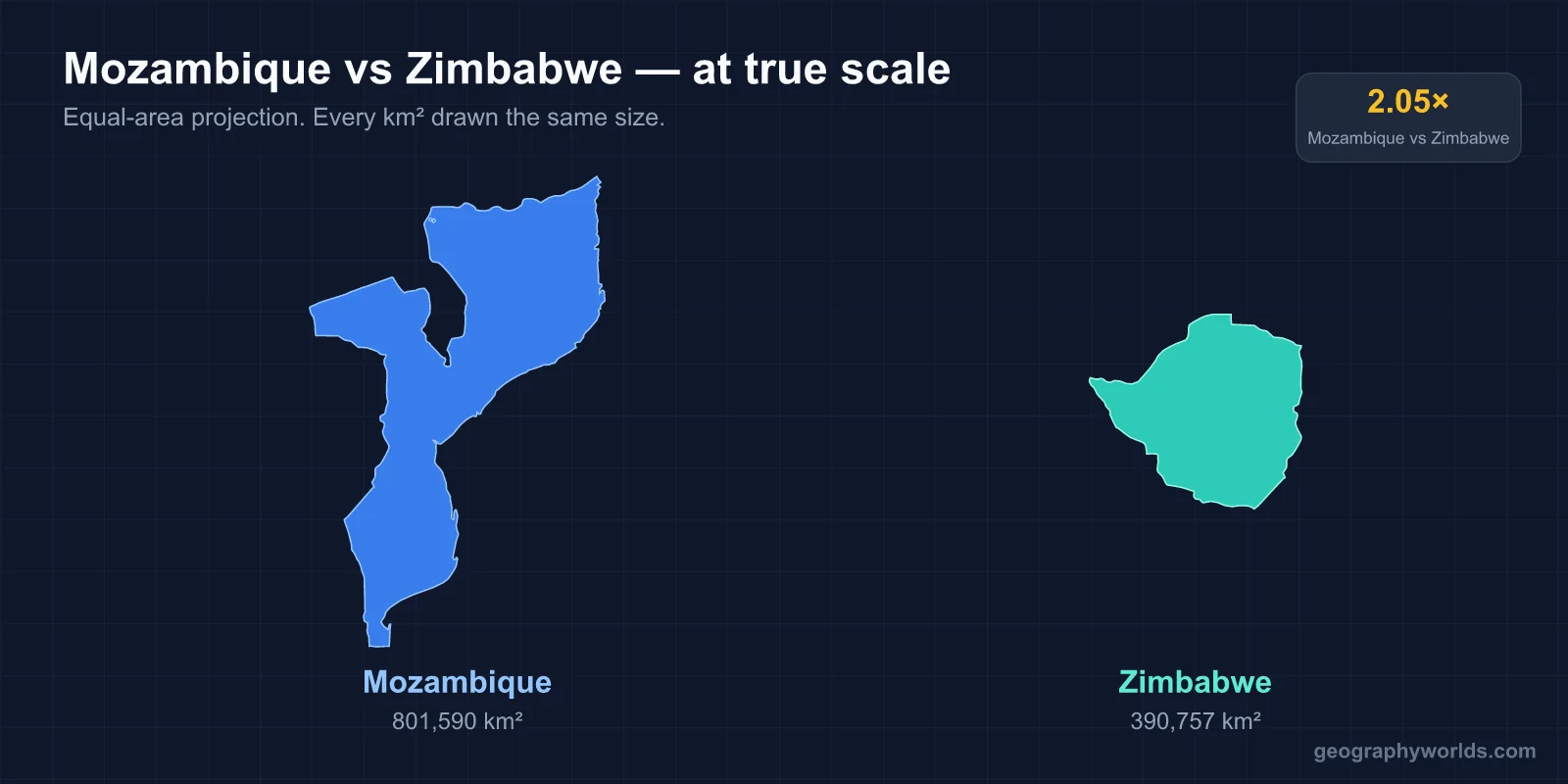
Mozambique covers 801,590 km², roughly 2.1 times the 390,757 km² of Zimbabwe. The contrast in shape matters as much as the raw size. Zimbabwe is landlocked, sitting mostly on a high plateau that rises toward a higher central plateau, which keeps much of the country well above the heat of the surrounding lowlands. Mozambique, by comparison, fans out from a long Indian Ocean coastline into coastal lowlands, then climbs to central highlands and a western plateau. The two countries also share a border with each other, and the four nations bordering Zimbabwe are a tight subset compared with the six that touch Mozambique, including Tanzania, Malawi, and Eswatini.
Population & Demographics
| Metric | Zimbabwe 🇿🇼 | Mozambique 🇲🇿 |
|---|---|---|
| Population | 17.3 million | 36.6 million |
| Population Density | 44.2 per km² | 45.7 per km² |
With 36.6 million people, Mozambique has about 2.1 times as many residents as Zimbabwe, which counts 17.3 million. What is striking is how little the population density differs despite that gap. Mozambique sits at 45.7 people per km² and Zimbabwe at 44.2, a margin of roughly 1.5 people per km². In other words, Mozambique has nearly double the people but also nearly double the land, so the crowding works out almost the same. The headcount scales with the territory rather than concentrating it.
Capital Cities
Zimbabwe is governed from Harare, while Mozambique's seat of government is Maputo. Both lie within the Southern Africa region. Their settings tell the wider story of each country: Harare sits up on Zimbabwe's interior plateau, whereas Maputo occupies a coastal position in Mozambique's far south, close to the borders with South Africa and Eswatini.
Language, Currency & Culture
| Aspect | Zimbabwe 🇿🇼 | Mozambique 🇲🇿 |
|---|---|---|
| Languages | English, Shona, Ndebele (plus 13 other official languages) | Portuguese (official), Makhuwa, Tsonga, Sena |
| Currency | Multiple currencies used including USD and ZAR | Mozambican Metical (MZN) |
Language is one of the clearest dividing lines between the two. Zimbabwe leans on English alongside Shona and Ndebele, with 13 further official languages on top of those, a reflection of its time under British administration and its many indigenous communities. Mozambique instead uses Portuguese as its official language, a legacy of Portuguese rule, layered over widely spoken African languages such as Makhuwa, Tsonga, and Sena. The money differs just as sharply: Zimbabwe relies on a mix of currencies that includes the US dollar and the South African rand, while Mozambique keeps its own national currency, the Mozambican Metical (MZN).
Climate & Natural Features
| Aspect | Zimbabwe 🇿🇼 | Mozambique 🇲🇿 |
|---|---|---|
| Climate | tropical; moderated by altitude; rainy season | tropical to subtropical |
| Key Features | Victoria Falls, Great Zimbabwe ruins, Eastern Highlands | Mozambique Channel, Bazaruto Archipelago, Zambezi River |
| Economy | mining, agriculture, tourism | agriculture, natural gas, fishing, mining |
Zimbabwe's climate is tropical but tempered by altitude, with a distinct rainy season, so its high ground stays milder than the latitude alone would suggest. Mozambique runs from tropical to subtropical, shaped far more by the ocean at its doorstep. That difference shows in the landmarks each country is known for. Zimbabwe's draws are inland and dramatic: Victoria Falls on the Zambezi, the stone ruins of Great Zimbabwe, and the Eastern Highlands. Mozambique's headline features are tied to the sea, including the Mozambique Channel, the Bazaruto Archipelago, and the lower reaches of the Zambezi River. The economies follow suit. Zimbabwe leans on mining, agriculture, and tourism, while Mozambique combines agriculture and fishing with mining and a growing natural gas sector.
What Makes Each Country Unique
Zimbabwe is known worldwide for Victoria Falls, counted among the Seven Natural Wonders, along with the Great Zimbabwe ruins and abundant wildlife. It also stands out for language: with 16 official languages, it ranks among the countries with the most official tongues anywhere on the planet.
Mozambique is defined above all by its long Indian Ocean shoreline, the Bazaruto Archipelago, and rich marine life. It also holds a curious distinction in vexillology, as its national flag depicts an AK-47 rifle, making it one of the very few flags in the world to feature a modern firearm.
Key Differences at a Glance
- Area: Zimbabwe (390,757 km²) vs Mozambique (801,590 km²) — Mozambique is 2.1x larger
- Population: Zimbabwe (17.3 million) vs Mozambique (36.6 million) — Mozambique is 2.1x more populous
- Capitals: Harare vs Maputo
- Currency: Multiple currencies used including USD and ZAR vs Mozambican Metical (MZN)
- Continents: Africa vs Africa
- Density: Mozambique is more densely populated (difference of ~1.5 people per km²)
- Languages: English vs Portuguese (official)
Verdict
For all that Zimbabwe and Mozambique share as Southern African neighbours, they end up as natural opposites. Mozambique is the larger of the two on both counts, holding 2.1 times the land and 2.1 times the people, yet because those two figures grow in step, its population density barely edges past Zimbabwe's. Size and crowding, it turns out, do not always tell the same story.
The deeper split is one of orientation. Zimbabwe is an inland, high-plateau country with a tropical climate softened by altitude, its identity bound up with Victoria Falls and a mining-led economy. Mozambique faces outward to the sea, with a tropical-to-subtropical climate and signature features like the Mozambique Channel, while agriculture anchors its economy alongside a rising gas sector.
Set against each other, the two countries make a useful pair for understanding how geography, history, and language shape a nation. Whether you are mapping out travel, studying the region, or simply feeding your curiosity, comparing them side by side fills in a fuller picture of Southern Africa.
Test Your Knowledge!
Think you know your countries? Try our interactive geography quiz!
Play Geography Games →