
What Are Antipodal Points and Opposite Points on Earth?
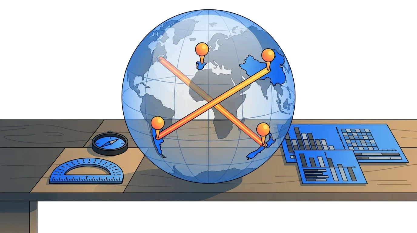
An antipode is the exact geographical opposite of any given spot on the globe. If you were to drive a straight rod from your current location directly through the center of the Earth, the place where it emerges on the other side is your antipodal point. These two locations sit as far apart as geographically possible on our planet.
The word comes from the ancient Greek term antipodes, combining anti (opposed) and pous (foot), which originally referred to people standing with their feet opposite to ours. Because the Earth is roughly spherical, every single square meter of land and sea has a unique opposite counterpart.
When two locations are true antipodes, their physical relationship creates exact astronomical and seasonal inversions:
- Maximum surface distance: Measured around the curve of the Earth, any two antipodal points are separated by half of the planet's circumference, or roughly 20,000 kilometers.
- Through-Earth distance: A straight line through the planetary core connecting the two spots equals Earth's diameter of about 12,742 kilometers.
- Inverted seasons: Because one point sits in the Northern Hemisphere and the other at the identical latitude in the Southern Hemisphere, summer at one location always corresponds to winter at its opposite.
- Opposite solar time: Positioned 180° of longitude apart, solar noon at one spot occurs at solar midnight at its antipode, creating a 12-hour difference in natural daylight.
These time and daylight inversions trace directly back to how fast the Earth spins on its axis relative to the Sun. While political time zones sometimes bend around national borders, the solar opposition between two antipodes never changes.
How to Calculate the Exact Antipode of Any Coordinate
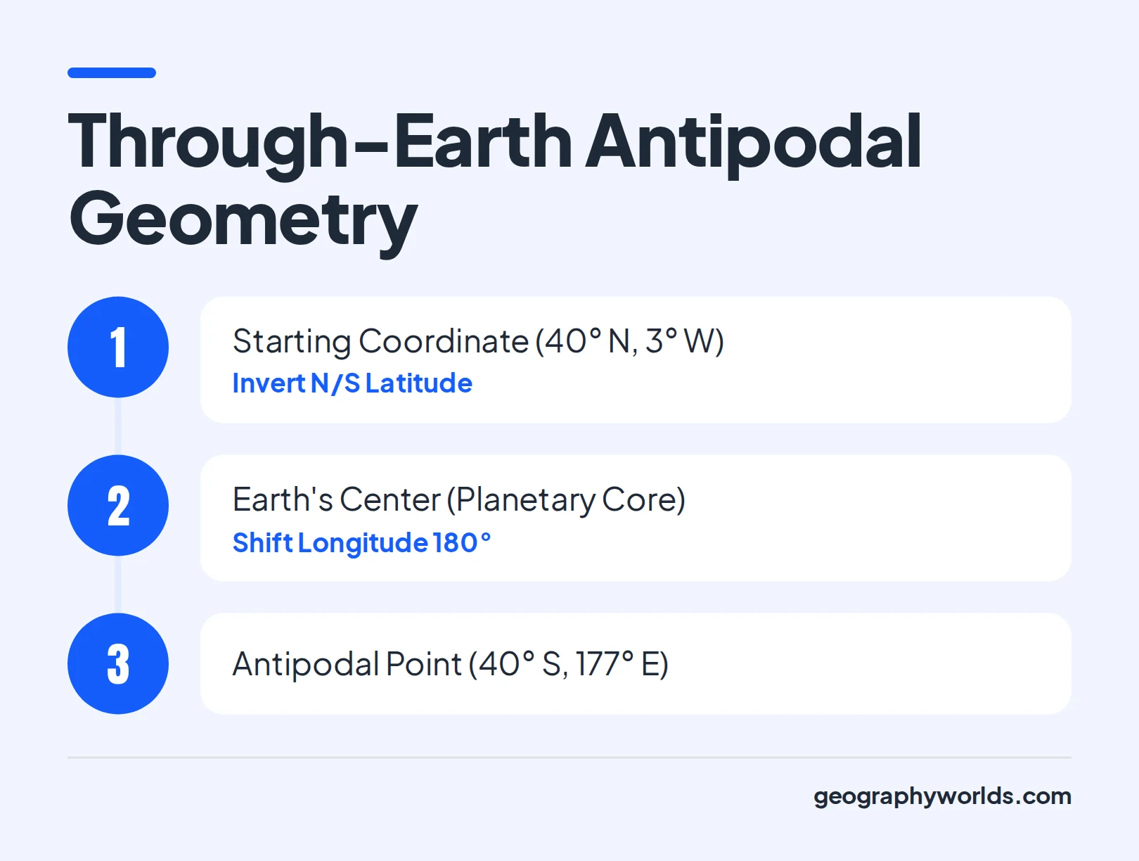
You do not need specialized cartography software to find what lies on the other side of the world from your hometown. Because standard geographic coordinates use a grid of latitude (North and South) and longitude (East and West), finding an antipode requires only two quick arithmetic steps.
- Flip the latitude hemisphere: Keep the exact numerical degree of latitude the same, but swap North (N) for South (S), or South for North.
- Subtract the longitude from 180°: Take your starting longitude number and subtract it from 180°, then swap East (E) for West (W), or West for East.
- Combine the new values: Pair your inverted latitude with your newly calculated longitude to pinpoint the exact opposite coordinate.
Worked Coordinate Examples
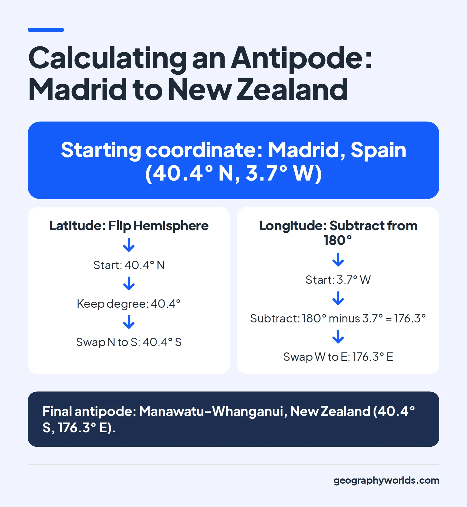
To see how this works in practice, take the central coordinates of Madrid, Spain, located at roughly 40.4° N, 3.7° W. First, flip the latitude from 40.4° N to 40.4° S.
Next, subtract the longitude from 180° (180° − 3.7° = 176.3°) and change West to East, giving you 40.4° S, 176.3° E. That exact spot lands in the rural Manawatu-Whanganui region of New Zealand's North Island, near the town of Dannevirke and just northeast of Wellington.
Now try an example starting in the Southern Hemisphere and Eastern Hemisphere, such as Perth, Australia, at roughly 31.95° S, 115.86° E. Flipping the latitude gives 31.95° N, and subtracting the longitude from 180° (180° − 115.86° = 64.14°) while swapping East to West gives 31.95° N, 64.14° W. Those coordinates drop you into the North Atlantic Ocean, right alongside the islands of Bermuda.
Tip: If you are working with decimal coordinates in a spreadsheet or mapping tool where South and West are written as negative numbers, flip the sign of the latitude (multiply by −1) and either add 180° to a negative longitude or subtract 180° from a positive longitude.
Why Only 4% of Earth's Surface Has Land-to-Land Antipodes
If you pick a random city on a world map and calculate its antipode, you will almost certainly end up in the middle of an ocean.
In addition, Earth's continental landmasses are heavily concentrated in the Northern Hemisphere, leaving the Southern Hemisphere dominated by vast stretches of the Pacific, Atlantic, and Indian Oceans.
- Africa's opposite: The entire African continent projects directly into the central and eastern Pacific Ocean, hitting almost no land aside from tiny coral atolls.
- Australia's opposite: Mainland Australia projects into the temperate North Atlantic Ocean, missing Europe and North America entirely (with only Bermuda sitting near the antipode of Western Australia).
- Eurasia's main mass: Most of Europe, Russia, the Middle East, and India project into the vast southern Pacific and southern Indian Oceans.
- North America's opposite: Canada, the United States, and Mexico project into the remote southern Indian Ocean between Africa, Australia, and Antarctica.
Where Continental Land Overlaps
Despite the ocean dominance, four major land-to-land antipodal zones account for that 4% planetary overlap. The largest continuous inhabited terrestrial overlap occurs between South America and East and Southeast Asia. Argentina and Chile sit directly opposite eastern China, Mongolia, and parts of southeastern Russia, while countries in northern South America like Colombia, Ecuador, Peru, and western Brazil overlap with Indonesia, Malaysia, the Philippines, and Vietnam.
A second major overlap links the polar regions: Antarctica, Earth's coldest continent, sits opposite the Arctic Circle, where its edges overlap with Greenland, northern Canada, and the Russian Arctic islands. Smaller but famous overlaps connect the Iberian Peninsula (Spain and Portugal) with New Zealand, and link Mauritanian and Malian West Africa or Botswana with island nations of the Pacific like New Caledonia, Fiji, and Hawaii.
Famous Antipodal Cities and True Opposite City Pairs
Geographers distinguish between exact antipodal cities (whose municipal limits literally overlap through the center of the Earth) and near-antipodal cities (major metropolitan areas within 100 to 200 kilometers of each other's exact opposite coordinate).
The table below compares eight of the world's most notable antipodal and near-antipodal urban pairs, showing their approximate coordinates and how closely they align.
Capital-to-Capital Near Opposites
No two national capitals have downtown cores that are exact antipodes down to the kilometer, but two capital pairs come remarkably close. Madrid, Spain, and Wellington, New Zealand, sit roughly 150 kilometers off each other's exact antipodal mark, making them the most famous European-Oceanian pairing. Even closer are Taipei, Taiwan, and Asunción, Paraguay, whose metropolitan fringes lie within roughly 80 kilometers of true opposition.
If you want to practice spotting where these cities sit on a blank map before testing their opposites, you can try the City Dot location game or explore the broader interactive city map quiz.
Antipodal city pairs cluster between Iberia and New Zealand, and between South America and Asia.
| City A | City B (Opposite) | Coordinates of City A | Alignment Type |
|---|---|---|---|
| Christchurch, New Zealand | A Coruña, Spain | 43.5° S, 172.6° E | Exact regional overlap |
| Hamilton, New Zealand | Córdoba, Spain | 37.8° S, 175.3° E | Exact urban overlap |
| Wellington, New Zealand | Alaejos (near Madrid), Spain | 41.3° S, 174.8° E | Near-antipodal capitals |
| Palembang, Indonesia | Neiva, Colombia | 3.0° S, 104.8° E | Exact urban overlap |
| Padang, Indonesia | Esmeraldas, Ecuador | 0.9° S, 100.4° E | Exact coastal overlap |
| Beijing, China | Bahía Blanca, Argentina | 39.9° N, 116.4° E | Near-antipodal cities |
| Shanghai, China | Salto, Uruguay / Concordia, Argentina | 31.2° N, 121.5° E | Exact river border overlap |
| Taipei, Taiwan | Asunción, Paraguay | 25.0° N, 121.5° E | Near-antipodal capitals |
Common Antipode Myths and the Digging to China Trap
Growing up in the United States, Canada, or the United Kingdom, generations of children have heard the popular phrase about digging a hole at the beach all the way to China. In reality, digging straight through the center of the Earth from anywhere in North America or Europe will never bring you out in Asia.
Because both North America and China lie entirely in the Northern Hemisphere, a straight tunnel between them would have to cut at a shallow chord through the Earth's mantle rather than passing through the planetary core.
Mainland China stretches across northern latitudes, meaning its true antipodes must lie at matching southern latitudes. If you want to dig straight through the Earth's core and emerge in China, you have to start your tunnel in Argentina or Chile.
Watch out: Even in geography trivia, players often forget to flip the hemisphere when visualizing the opposite side of the globe. Always cross the Equator first in your mind before shifting 180° east or west.
Where North America and Europe Actually Emerge
If you actually drilled straight through the core from North America or the countries in Europe, here is where your tunnel would exit:
- Continental United States and Canada: Almost the entire mainland US and Canada emerge in the frigid southern Indian Ocean, thousands of kilometers southwest of Australia.
- The Montana-Alberta exception: A tiny patch of land along the US-Canada border in northern Montana (near Rudyard and Havre) and southern Alberta and Saskatchewan is antipodal to the remote French Southern and Antarctic Lands, specifically the Kerguelen Islands.
- Hawaii (Big Island and Maui): The Hawaiian Islands are the only US state land with a continental antipode, emerging in the Okavango Delta and Kalahari regions of Botswana and Namibia.
- United Kingdom and France: London, Paris, and Berlin all emerge in the South Pacific Ocean southeast of New Zealand; only a small coastal tip of Normandy in northern France (on the Cotentin Peninsula near Cherbourg and Gatteville-le-Phare) hits the subantarctic Antipodes Islands.
Test Your Intuition With the Interactive Antipode Game
Reading coordinate tables is one thing, but visualizing an inverted globe under time pressure is much trickier. You can put your spatial intuition to the test in the Antipode interactive game, where the prompt asks you to dig straight through the Earth and guess where you come out.
It is part of the free interactive challenges available in the Geography Worlds games collection, playable instantly across devices without creating an account. Whether you are a teacher demonstrating coordinate geometry in class or a trivia player sharpening your mental map, a few quick habits will help you score higher:
- Anchor on the four land overlaps: Whenever the starting point lands in Spain, New Zealand, South America, or East and Southeast Asia, look immediately for the matching partner continent.
- Watch the Tropic lines: A starting spot near the Tropic of Cancer (23.5° N) in Mexico, Egypt, or India will always emerge near the Tropic of Capricorn (23.5° S).
- Expect ocean traps for northern cities: If a round starts in North America, northern Europe, or central Africa, resist the urge to click a nearby continent and check the southern oceans and island chains first.