

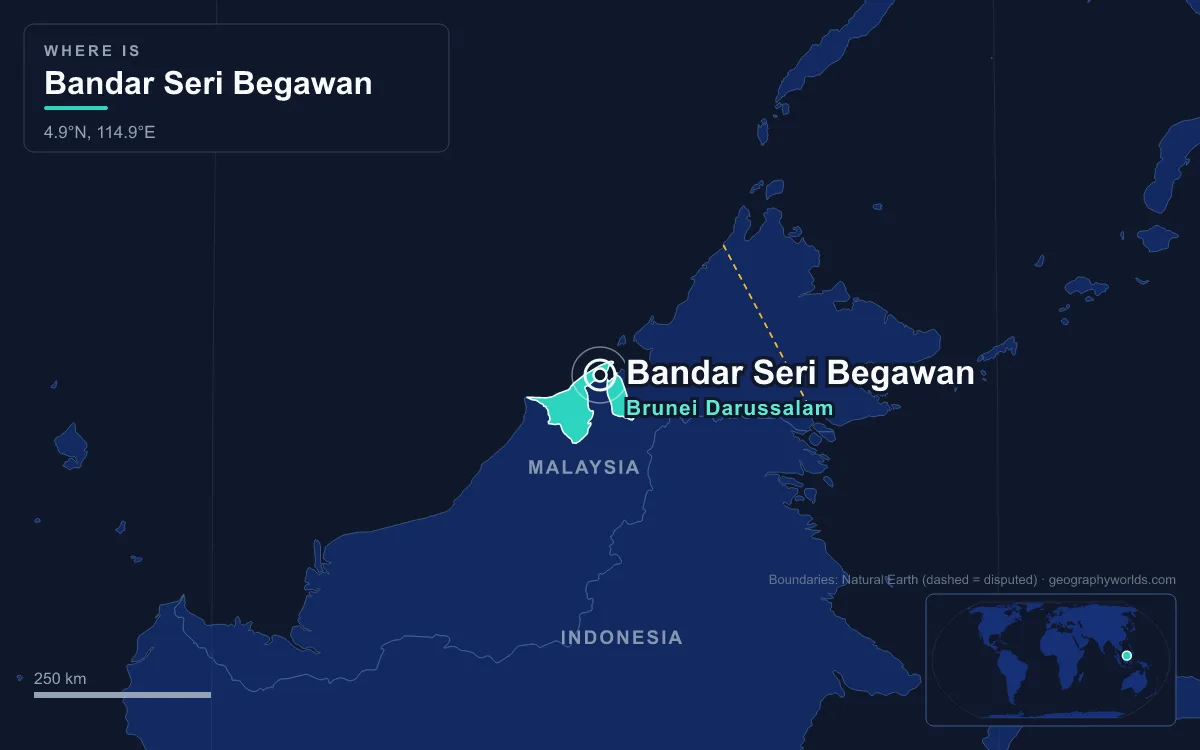
Bandar Seri Begawan, called Brunei Town until 1970, is the capital and largest city of Brunei. It lies on the Brunei River, upstream from where the river empties into Brunei Bay, on the northern coast of Borneo. The municipal area covers 100.36 square kilometres, and 2025 estimates put its population at roughly 64,000 to 72,000, depending on the source. The wider Brunei–Muara District is home to more than 70 percent of the country's people. The city's defining feature is its double shape. There is a modern government town on the riverbank, and next to it Kampong Ayer, a water village of stilt houses that was the capital for centuries before anyone built on dry land. The city's history falls into a series of distinct eras.
The Water Capital of Sultan Bolkiah, 1485–1578
Brunei's early capital stood on the water. Its first stage grew up near present-day Kota Batu, downstream of today's centre, and later the heart of the settlement moved to the stilt villages of Kampong Ayer. The high point came under Sultan Bolkiah, who reigned from 1485 until his death in 1524. Bruneian tradition calls his reign the golden age, when the sultanate dominated much of Borneo and the southern Philippines. He is said to have paid Javanese smiths to teach metal casting, which may be how cannon-making came to Brunei. His tomb, and that of the earlier ruler Sharif Ali, are still at Kota Batu, where the Kota Batu Archaeological Park also holds the Brunei Museum.

Europeans saw the city at its peak. In 1521 Antonio Pigafetta, the chronicler of Ferdinand Magellan's last voyage, visited Brunei and described the water settlement. The nickname "Venice of the East" is traditionally credited to him. Later visitors noted that the houses stood on piles about three metres above high tide. Kampong Ayer is still the largest stilt settlement of its kind, spread along roughly 8 kilometres of the river.
Castilian War and Long Decline, 1578–1841
The golden age ended in conflict with Spain. In 1578 Spanish forces from the Philippines attacked Kampong Ayer in what became known as the Castilian War, and the Spanish–Moro conflicts that followed ran on and off for over 300 years. As Brunei lost authority, pirates, including impoverished princes from the royal families of Sulu and Brunei, used the gap. The capital itself became a centre for raiding and for trade in stolen goods and slaves, which the sultan tried to regulate and tax.
By the nineteenth century the city looked little different from Pigafetta's time, only poorer. In 1841 James Brooke, soon to be the "White Rajah" of neighbouring Sarawak, called it a "Venice of hovels". Houses stood on mudflats that were exposed at low tide, a floating market crowded the channels, and the sultan's palace had declined badly. Over the next decades Brunei ceded Kuching to Brooke and gave up Sabah to the British North Borneo Company. Britain attacked the capital in July 1846 in a succession dispute.
Protectorate and Residency, 1888–1941
On 17 September 1888 Sultan Hashim Jalilul Alam Aqamaddin signed a Protectorate Agreement, negotiated by Sir Hugh Low, which gave Britain control of Brunei's foreign affairs. It did not stop the Brookes. In 1890 Sarawak annexed the Limbang district, the capital's natural hinterland and the source of food and resources for the river villages. The loss split Brunei into the two separate pieces it still has today.
The modern land-based town dates from 1906, when the Supplementary Protectorate Agreement installed a British Resident. The British official Malcolm McArthur, who guided this phase, found 8,000 to 10,000 people living in Kampong Ayer and set out to build a colony on shore, starting with his own residence, Bubungan Dua Belas. By 1910 Chinese immigrants had opened shops on land. The area was formally designated Brunei's capital in 1920, when government buildings and a mosque were put up along the western riverbank. A Sanitary Board to manage the town was set up on 1 January 1921, and the town gained municipal status in 1935. In 1922 Sultan Muhammad Jamalul Alam II moved his palace from the water into the town, which encouraged Kampong Ayer families to move ashore. Meanwhile the country's fortunes shifted west. Oil was struck at Seria on 5 April 1929, and the oil towns of Seria and Kuala Belait began to compete with the capital.
Japanese Occupation and Allied Bombing, 1941–1945
Japanese forces landed at Kuala Belait and took Brunei Town on 22 December 1941. The occupation brought forced harvest quotas, Japanese-language schooling and brutal policing by the Kempeitai. In November 1944 the Allies began bombing the town, and after three days of fighting, American and Australian forces captured Brunei on 10 June 1945. It had had about 16,000 people during the war, and bombing destroyed almost all of the town's homes and businesses, leaving residents to watch from the surrounding hills or shelter in the bush. One piece of wartime construction lasted. Japanese forces had built a runway at Berakas, and after the war the capital's airport services ran from that old runway site until the present Brunei International Airport opened in 1974.
Omar Ali Saifuddien's Rebuilding, 1950–1967
The city's post-war shape belongs to Sultan Omar Ali Saifuddien III, the 28th sultan. In 1953 he launched a five-year National Development Plan worth M$100 million, paid for partly by higher taxes on the oil companies that he negotiated with Britain. The plan's centrepiece was a new state mosque. Work began on 4 February 1954 on a site beside the river, which the sultan chose so that Kampong Ayer residents could reach it easily, and the Omar Ali Saifuddien Mosque was completed in 1958 at a cost of about US$5 million. Its gold dome, Italian marble and man-made lagoon with a ceremonial stone barge made it the city's landmark.
Politics moved quickly in these years. A new constitution in 1959 ended the Residency system. By 1960 Brunei's population had reached 83,877, and the Chinese community, heavily involved in trade in the capital, made up about a quarter of it. On 8 December 1962 the North Kalimantan National Army rose in the Brunei revolt, attacking the Shell installations at Seria, police stations and government buildings across the protectorate, including in the capital. British forces, including Gurkhas and Royal Marines, had retaken most key centres by 11 December. The revolt helped persuade the sultan to keep Brunei out of the new Federation of Malaysia. In 1967 he abdicated in favour of his son, Hassanal Bolkiah, and took the title Seri Begawan.
Brunei Town Becomes Bandar Seri Begawan, 1970–1984
On 4 October 1970 the capital was renamed in the retired sultan's honour. Seri Begawan comes from a Sanskrit phrase meaning roughly "the shining and saintly". Oil and gas money paid for a central business district and a wave of public buildings in the 1970s and early 1980s. New suburbs spread north along Jalan Berakas and Jalan Muara and west along Jalan Tutong and Jalan Gadong.
The era ended with two landmarks in the same year. At midnight on 1 January 1984, Sultan Hassanal Bolkiah proclaimed Brunei's full independence at the city park now called Taman Haji Sir Muda Omar 'Ali Saifuddien. The same year Istana Nurul Iman, the "Palace of the Light of Faith", was completed a few kilometres southwest of the centre, on the banks of the Brunei River. It was designed by the Filipino architect Leandro Locsin and built by about 10,000 workers from 17 countries at a cost of around US$1.4 billion. Guinness World Records lists it as the largest residential palace in the world.
The 100-Square-Kilometre Capital, 2007 to Today
The city's boundaries changed on 1 August 2007, when the sultan approved expanding the municipal area from 12.87 to 100.36 square kilometres. Mukims (sub-districts) including Berakas, Gadong, Kilanas and Kota Batu came inside the city limits. That is why population figures for the capital vary so much: the 2011 census gave around 20,000 for the old core and about 280,000 for the wider metropolitan area.
Kampong Ayer is smaller than it used to be. It covers about 10 square kilometres and had 10,250 residents in 2016, with its houses, schools and mosques all standing on stilts above the river beside the city centre.

The capital's reach grew in 2020 when the 30-kilometre Temburong Bridge opened across Brunei Bay. It is the longest bridge in Southeast Asia, and it links the city directly to the Temburong District, the eastern part of Brunei that was cut off by the loss of Limbang in 1890. Before the bridge, drivers had to pass through Malaysian territory at Limbang. The equatorial climate still sets the limits: on 9 July 2020 the airport recorded 662 millimetres of rain in a single day, the wettest day on record there.
The city has hosted the 1999 Southeast Asian Games and the 2000 APEC summit, but the scale is still that of a town. For how the sultanate fits into the island it shares with two other countries, see the guide to the geography of Borneo. The Brunei country guide covers the oil towns and rainforest beyond the capital, and a short flight west leads to a very different Malay capital, Kuala Lumpur.
Quick Facts About Bandar Seri Begawan
- Country: Brunei
- Continent: Asia (Southeast Asia)
- Country population: approximately 470 thousand
- Capital city status: Bandar Seri Begawan is the capital of Brunei, the seat of national government, and the location of foreign embassies, parliament, and the head of state's official residence.
Frequently Asked Questions
What is the capital of Brunei?
The capital of Brunei is Bandar Seri Begawan. Bandar Seri Begawan is the seat of national government, hosts most foreign embassies and consulates, and is typically where the head of state and parliament are located.
What continent is Bandar Seri Begawan in?
Bandar Seri Begawan, the capital of Brunei, is located in Asia, in the Southeast Asia region. As Brunei's capital, Bandar Seri Begawan serves as the country's primary connection to the broader Asian political, economic, and cultural sphere.
Why is Bandar Seri Begawan the capital of Brunei?
Bandar Seri Begawan was chosen as the capital of Brunei for reasons that typically combine geography, history, and politics. Capital city selections often reflect a desire for centrality (being accessible from across the country), historical importance (being a longstanding seat of government or culture), or neutrality (being acceptable to multiple regions or ethnic groups within the country). The specific reasons for Bandar Seri Begawan's designation are detailed in the city's history above.
What is Bandar Seri Begawan known for?
As the capital of Brunei, Bandar Seri Begawan is best known for housing the country's central government institutions — parliament, presidential or royal residences, supreme court, and key ministries. It is also typically a major cultural and economic center within Brunei, hosting national museums, embassies, and signature monuments. The introduction and history sections above provide detailed coverage of the city's specific notable institutions and landmarks.
Related Pages
- Brunei Country Guide — full geography, climate, economy, and culture overview
- Flag of Brunei — meaning, history, and design of Brunei's national flag