
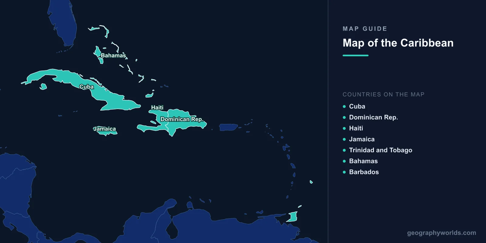
The Caribbean consists of the Caribbean Sea — about 2.75 million km², the world's second-largest sea — and over 7,000 islands, islets, reefs and cays, of which 13 are sovereign island nations holding roughly 44 million people. On a map the region resolves into three distinct groups: the large mountainous Greater Antilles, the volcanic arc of the Lesser Antilles, and the low coral platforms of the Bahamas and Turks and Caicos.

The Caribbean looks scattered on a world map, but its arrangement is not random at all. Almost every island's size, shape, height and soil is explained by the boundaries of the Caribbean Plate — a relatively small tectonic plate whose edges produce volcanoes on one side, earthquakes on another, and deep ocean trenches on a third. Learn the plate and the map becomes legible.
The Region at a Glance
- Caribbean Sea area: about 2.75 million km² (1.06 million sq mi)
- Population: roughly 44 million across the island nations and territories
- Sovereign island states: 13
- North–south extent: around 3,200 km, from the Bahamas near 25°N to Trinidad at about 10°N
- Largest island: Cuba, about 109,884 km²
- Highest point: Pico Duarte, Dominican Republic, about 3,098 m
- Deepest point in the sea: the Cayman Trough, roughly 7,686 m
- Deepest point nearby: the Puerto Rico Trench, about 8,376 m — the deepest point in the Atlantic Ocean
Three Island Groups, Three Different Origins
The Greater Antilles — Cuba, Hispaniola (shared by Haiti and the Dominican Republic), Jamaica and Puerto Rico — hold roughly 90% of the Caribbean's land area and the great majority of its population. These are old, complex islands built from limestone, volcanic and metamorphic rock, uplifted along the northern boundary of the Caribbean Plate. They are big enough to have real interiors: mountain ranges such as Hispaniola's Cordillera Central and Jamaica's Blue Mountains, extensive karst landscapes, and river systems.
The Lesser Antilles curve south and east from the Virgin Islands to Trinidad, and they are a textbook volcanic island arc. Here the Atlantic seafloor is subducting westward beneath the Caribbean Plate, and the rising magma has built a chain of steep, young, mostly small volcanic islands: Dominica, Saint Lucia, Saint Vincent, Grenada, Montserrat, Martinique, Guadeloupe and Saint Kitts among them. The arc is doubled in places, with an outer ring of older, flatter limestone islands — Antigua, Barbuda, Anguilla — representing an earlier, now-extinct volcanic line that has since been capped by coral limestone.
The Bahamas and Turks and Caicos are a different animal entirely, and technically sit in the Atlantic rather than the Caribbean Sea. They are low carbonate platforms — accumulated marine sediment on a submerged bank — with almost no relief; the highest point in the Bahamas is barely 60 m. The shallow banks surrounding them produce the turquoise water visible from orbit.
Barbados is a case of its own: an uplifted block of coral limestone sitting on the accretionary prism east of the volcanic arc, entirely in the Atlantic, low and flat where its volcanic neighbours are steep and green.
The Island Nations and Territories
- Cuba — Havana; about 109,884 km²; roughly 11 million; the largest island by a wide margin. See our Cuba island guide.
- Haiti — Port-au-Prince; about 27,750 km²; roughly 11.7 million; western Hispaniola, mountainous and severely deforested.
- Dominican Republic — Santo Domingo; about 48,671 km²; roughly 11 million; eastern Hispaniola, containing the Caribbean's highest peak. See our Dominican Republic geography guide.
- Jamaica — Kingston; about 10,990 km²; roughly 2.8 million; limestone and karst with the Blue Mountains rising to about 2,256 m. See our Jamaica guide.
- Trinidad and Tobago — Port of Spain; about 5,131 km²; roughly 1.4 million; geologically part of South America, and the region's main oil and gas producer.
- Bahamas — Nassau; about 13,943 km² of land spread over 700-plus islands and cays; roughly 400,000 people.
- Barbados — Bridgetown; about 430 km²; roughly 288,000; the easternmost Caribbean state.
The remaining sovereign states are Antigua and Barbuda, Dominica, Grenada, Saint Kitts and Nevis, Saint Lucia, and Saint Vincent and the Grenadines. Alongside them sit a large number of non-independent territories: Puerto Rico and the US Virgin Islands (United States); the Cayman Islands, British Virgin Islands, Turks and Caicos, Anguilla and Montserrat (United Kingdom); Guadeloupe, Martinique, Saint Martin and Saint Barthélemy (France, and fully part of the EU); and Aruba, Curaçao, Bonaire and Sint Maarten (Netherlands). Most of the independent states coordinate through CARICOM — see our CARICOM guide.
Tectonics: Volcanoes, Quakes and Trenches
The Caribbean Plate's three active margins each produce a different hazard.
Along the eastern margin, subduction drives the Lesser Antilles volcanoes. This arc has produced some of the deadliest eruptions in the Western Hemisphere: Mount Pelée on Martinique destroyed the town of Saint-Pierre in 1902, killing roughly 30,000 people in minutes. Soufrière Hills on Montserrat began erupting in 1995 and buried the capital, Plymouth, forcing the permanent abandonment of over half the island. La Soufrière on Saint Vincent erupted explosively as recently as 2021.
Along the northern margin, the plate boundary is dominated by strike-slip faulting rather than subduction — which means earthquakes rather than volcanoes. This is why Cuba, Hispaniola and Jamaica have no active volcanoes but a long record of destructive quakes, including the 2010 Haiti earthquake and the 1692 event that destroyed Port Royal in Jamaica. The Cayman Trough, the sea's deepest point at about 7,686 m, is a pull-apart basin along this same fault system.
Just north of Puerto Rico, the Puerto Rico Trench drops to about 8,376 m, the deepest water anywhere in the Atlantic. The vertical distance from the trench floor to the top of Pico Duarte on Hispaniola exceeds 11 km within a few hundred kilometres of horizontal distance — one of the steeper crustal gradients on the planet.
Sea, Reefs and Hurricanes
The Caribbean Sea is warm, clear and nutrient-poor — a combination that is bad for fisheries but ideal for coral. Sea surface temperatures average around 27°C. The Mesoamerican Barrier Reef, running roughly 1,000 km from Mexico past Belize to Honduras, is the second-longest reef system in the world after Australia's Great Barrier Reef.
Those same warm waters power the Atlantic hurricane season, which runs 1 June to 30 November and peaks from August to October. Hurricanes form over the tropical Atlantic and typically track west into the Lesser Antilles before curving northwest through the Greater Antilles or the Bahamas. The geographic consequences are severe and unevenly distributed: Trinidad and the ABC islands (Aruba, Bonaire, Curaçao) sit largely south of the main track and are rarely hit, while the northern Leewards and the Bahamas are exposed almost every year. Our hurricane zones guide maps this in detail.
Rainfall varies enormously over short distances because of orographic effects. Aruba, low and downwind, receives perhaps 500 mm a year and is genuinely arid; Dominica's mountainous interior can exceed 7,600 mm. On a single mountainous island, the windward east coast may be rainforest while the leeward west coast is dry scrub — which historically determined where plantations, and therefore population, were established.
Caribbean vs Pacific Islands: Two Very Different Archipelagos
Comparing the Caribbean with the Pacific island world clarifies what makes it distinctive.
- Density and proximity: the Caribbean packs 7,000-plus islands into a compact sea, with most neighbours visible or a short flight away. Pacific island nations are separated by thousands of kilometres of open ocean — Kiribati alone spreads across an area comparable to the continental United States.
- Island type: the Caribbean is dominated by large continental-style islands plus a volcanic arc. The Pacific is dominated by hotspot volcanic islands and coral atolls, a type almost absent from the Caribbean.
- Elevation and risk: most Caribbean states have high ground to retreat to; many Pacific atoll nations, such as Tuvalu and the Marshall Islands, average only 2–3 m above sea level, making sea-level rise an existential rather than merely severe threat.
- Storms: both face tropical cyclones — hurricanes in the Atlantic, typhoons and cyclones in the Pacific — but the Caribbean's storms are concentrated into a shorter, sharper season.
- Markets: the Caribbean sits beside the largest economy in the world, which is why tourism dominates its economies. Pacific islands are remote from any major market, and depend more on fishing licences, remittances and aid.
For a wider survey, see our guide to island countries of the world.
Environment and the Vulnerability Problem
The Caribbean has exceptional biodiversity for its land area, and is designated a global biodiversity hotspot. Endemism is high because islands isolate populations: Cuba alone has on the order of 6,500 plant species, over half of them found nowhere else, and Hispaniola, Jamaica and Puerto Rico each have their own distinctive assemblages, including the world's smallest bird, Cuba's bee hummingbird.
That biological wealth sits alongside acute vulnerability. Most Caribbean states are Small Island Developing States, and they share a specific set of geographic disadvantages: small land area, long coastlines relative to area, limited fresh water, high import dependence, economies concentrated in tourism, and exposure to storms that can erase a year's GDP in a day. Many settlements and nearly all tourism infrastructure sit less than 10 m above sea level.
Climate change presses on all of these at once — sea-level rise, more intense storms, coral bleaching from marine heatwaves, and beach erosion that directly undermines the tourism economy. Add the sargassum seaweed influxes that have affected eastern coasts since about 2011, and the region's environmental challenges are less a future prospect than a present operating condition.
Read the relief map, though, and you can still see the underlying logic clearly: a plate boundary drawing a volcanic arc through warm water, big old islands to the north, coral banks to the northwest, and everything shaped by where the trade winds and hurricanes go.