
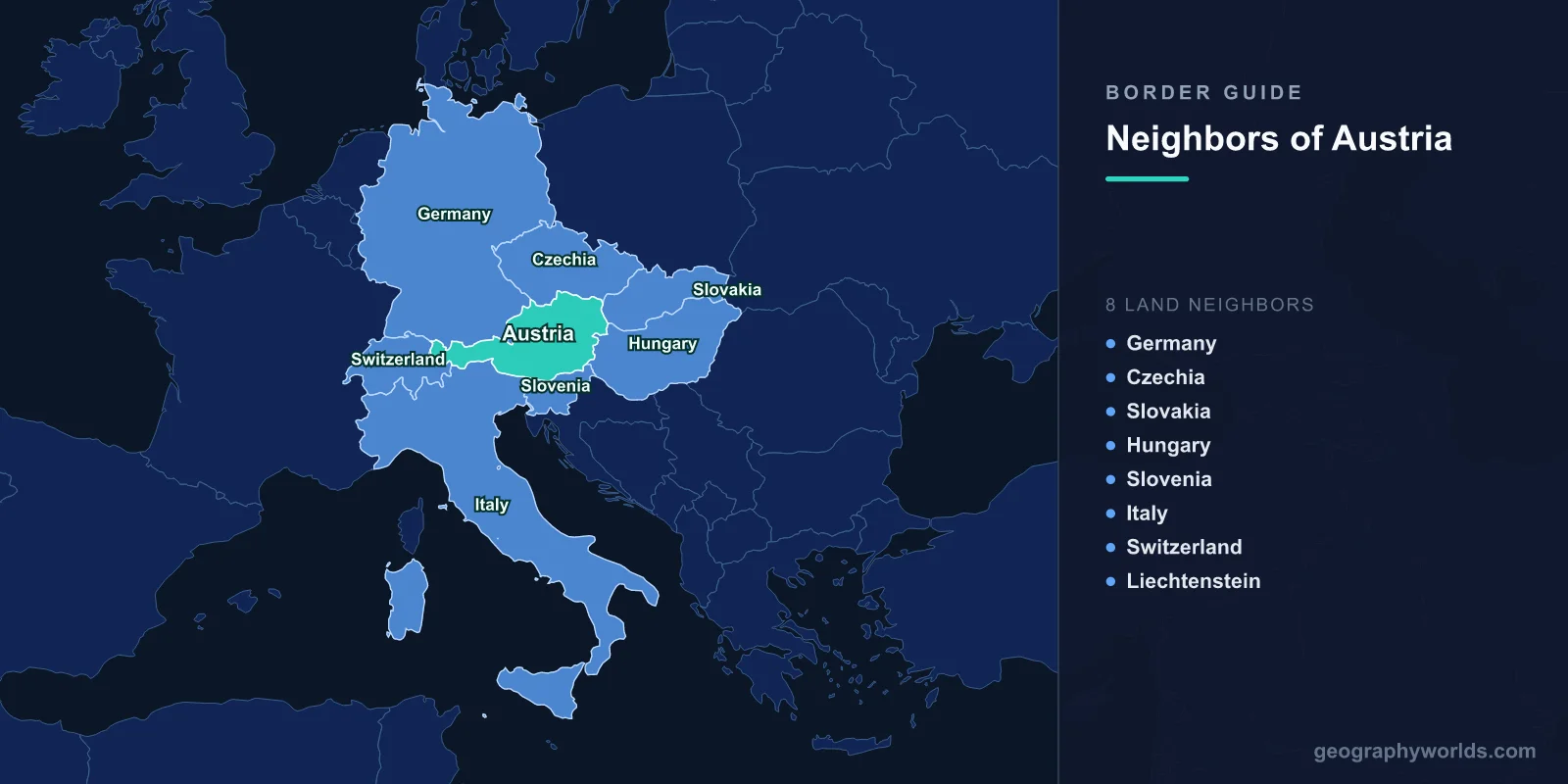
Austria shares land borders with 8 countries: Germany (801 km), Czech Republic (402 km), Slovakia (105 km), Hungary (321 km), Slovenia (299 km), Italy (404 km), Switzerland (158 km), and Liechtenstein (34.9 km), totaling approximately 2,524 km of land boundaries.
Introduction
Landlocked in the heart of Central Europe, Austria sits at the crossroads of Germanic, Slavic, Romance, and Magyar cultures. The Alps dominate the western two-thirds of the country, creating dramatic mountain borders with Italy, Switzerland, and Liechtenstein. To the north and east, the borders follow gentler terrain along the Danube Valley and the Pannonian Basin. Austria's central position made it the core of the Habsburg Empire for centuries, and its borders with eight nations reflect this legacy as a meeting point of European civilizations.

Complete List of Countries Bordering Austria
- Germany: 801 km
- Italy: 404 km
- Czech Republic: 402 km
- Hungary: 321 km
- Slovenia: 299 km
- Switzerland: 158 km
- Slovakia: 105 km
- Liechtenstein: 34.9 km
With 8 neighbors, Austria is tied with France for the most land borders in Western/Central Europe. All eight of Austria's neighbors are either EU members or closely associated with the EU (Liechtenstein is in the EEA and Switzerland has bilateral agreements), making Austria's borders among the most open in the world.
Northern Borders: Germany and Czech Republic
- Germany border: 801 km — Austria's longest, sharing language and culture
- Czech Republic border: 402 km — runs from the Bohemian Forest to the Moravian lowlands
The Austrian-German border is Austria's longest at 801 km and connects two German-speaking nations with deep cultural ties. The border runs from Lake Constance (Bodensee) in the west through the Alps to the Inn Valley and then along gentler terrain through Bavaria to the tripoint with the Czech Republic. Salzburg, Mozart's birthplace, sits directly on this border.
Austria's 402 km border with the Czech Republic traverses the Bohemian Forest (Böhmerwald) and the Waldviertel region. During the Cold War, this was part of the Iron Curtain — the heavily fortified frontier between the Western and Eastern blocs. The Czech border town of Znojmo and Austrian town of Retz are now linked by cross-border wine trails.
Eastern Borders: Slovakia and Hungary
- Slovakia border: 105 km — Vienna and Bratislava are just 60 km apart
- Hungary border: 321 km — from the Danube to the Pannonian Plain
The Austrian-Slovak border is just 105 km long, but it connects two national capitals that are closer together than any other pair in the world. Vienna and Bratislava are separated by only 60 km, and the Danube River links them. Both cities were historically part of the same Habsburg domain.
The 321 km Austrian-Hungarian border crosses the flat Pannonian Plain and the wetlands around Lake Neusiedl (Fertő), a UNESCO World Heritage site shared by both countries. This border gained worldwide fame in 1989 when Hungary began dismantling its border fences, triggering the chain of events that led to the fall of the Berlin Wall. The Pan-European Picnic near Sopron on August 19, 1989, saw hundreds of East Germans cross into Austria through a temporarily opened gate.
Southern and Western Alpine Borders
- Slovenia border: 299 km — through the Karawanken Alps and Carinthia
- Italy border: 404 km — crosses the Brenner Pass and South Tyrol
- Switzerland border: 158 km — Alpine terrain around Vorarlberg
- Liechtenstein border: 34.9 km — one of Europe's shortest borders
The Austrian-Slovenian border runs 299 km through the Karawanken Alps and the province of Carinthia, home to a Slovenian-speaking minority. The Loibl Pass tunnel connects the two countries through the mountains.
Austria and Italy share a 404 km Alpine border, anchored by the Brenner Pass at 1,370 meters — the lowest major crossing of the main Alpine ridge and one of Europe's busiest transport corridors. South Tyrol on the Italian side was part of Austria until 1919, and its German-speaking majority maintains strong cultural ties to Austria.
The Swiss border (158 km) and the tiny Liechtenstein border (34.9 km) both lie in Austria's westernmost province of Vorarlberg, in the Rhine Valley and surrounding Alps. Liechtenstein, squeezed between Austria and Switzerland, is one of only two doubly landlocked countries in the world.
Historical Border Changes
Austria's current borders bear little resemblance to the vast Habsburg Empire, which at its height controlled much of Central Europe, the Balkans, and parts of Italy. The empire's dissolution after World War I in 1918 reduced Austria to a small landlocked republic. The Anschluss with Nazi Germany in 1938 temporarily erased Austria's borders entirely. Post-World War II, Austria was occupied by the Allies until 1955, when the Austrian State Treaty restored full sovereignty. The end of the Cold War in 1989 transformed Austria's eastern borders from Iron Curtain frontiers to open EU boundaries, reconnecting Austria with its historical neighbors.
Key Facts
- Austria shares borders with 8 countries — tied for most in Western/Central Europe
- Vienna and Bratislava (60 km apart) are the world's closest national capitals
- The Brenner Pass has been the most important Alpine crossing for over 2,000 years
- Austria's Czech border was once part of the Iron Curtain during the Cold War
- All 8 of Austria's neighbors are EU members or closely associated with the EU
Fun Facts
- In 1989, Austria's border with Hungary was where the Iron Curtain first opened — the Pan-European Picnic let hundreds of East Germans escape to the West.
- Liechtenstein, wedged between Austria and Switzerland, is one of only two doubly landlocked countries in the world (the other is Uzbekistan).
- The Brenner Pass motorway is the busiest freight route in the Alps, with 2.5 million trucks crossing annually.
- Austria nearly became part of Germany permanently — it took the Allies' Moscow Declaration of 1943 to ensure Austrian independence after World War II.
Final Thoughts
Austria's eight borders place it at the very heart of Europe, connecting Germanic, Slavic, Romance, and Magyar worlds. From the Alpine grandeur of the Brenner Pass to the Danubian capitals of Vienna and Bratislava, Austria's frontiers are a microcosm of European history — from imperial grandeur through Cold War division to modern open borders.
Test Your Knowledge!
Think you know your borders and boundaries? Try our interactive geography quiz!
Play Geography Games →