
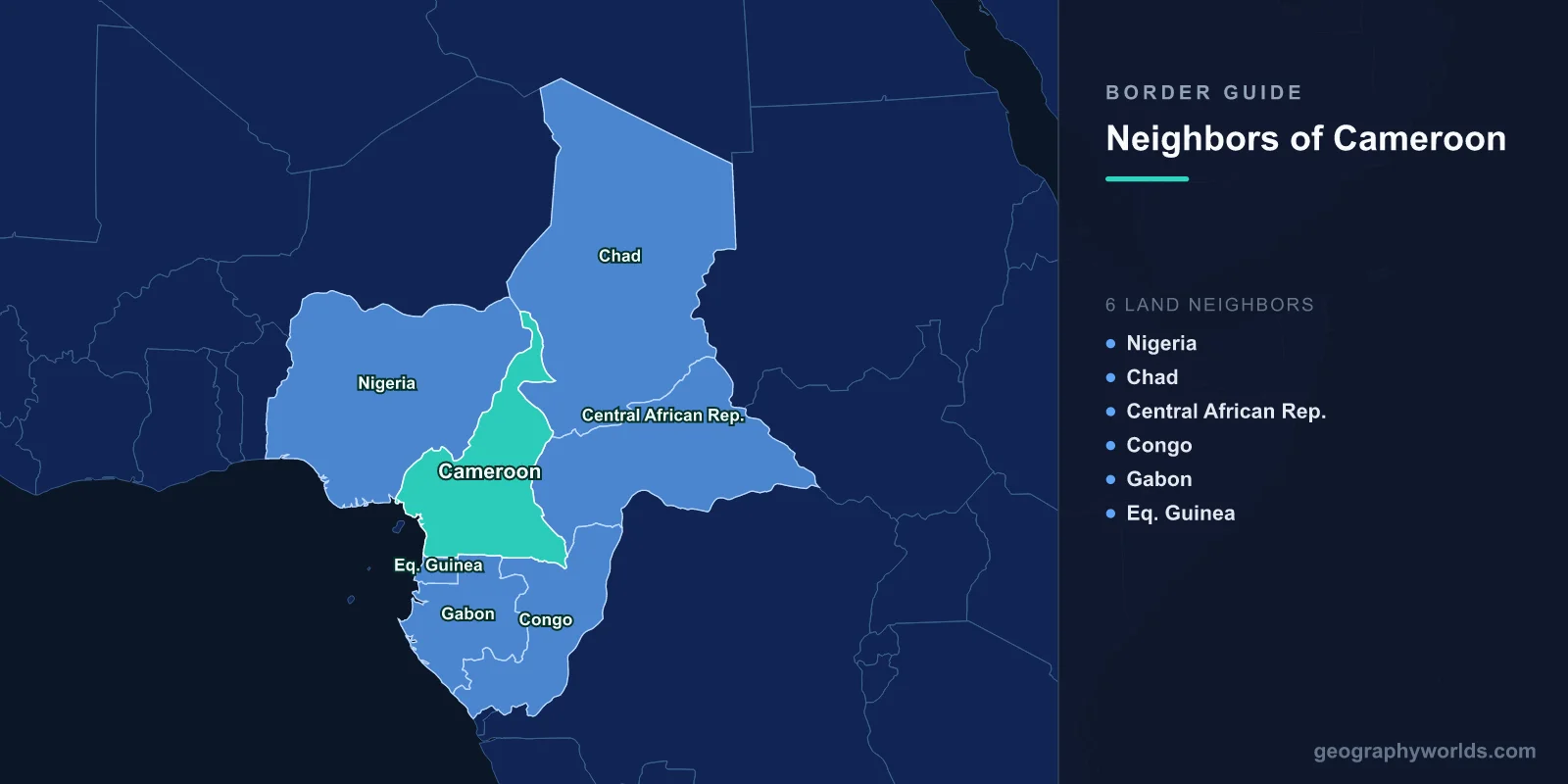
Cameroon shares land borders with six countries: Nigeria to the west and north-west, Chad to the north-east, the Central African Republic to the east, and the Republic of the Congo, Gabon and Equatorial Guinea to the south. The Gulf of Guinea forms a short south-western coast. The country's shape — a long wedge narrowing from Lake Chad to the Atlantic — means it touches the Sahel, the equatorial forest and the sea, and its borders were assembled from German, French and British colonial claims that changed hands twice.
The Peninsula That Went to the World Court
The Bakassi peninsula is a low, mangrove-covered arm of land at the mouth of the Cross river, inhabited mainly by Efik fishing communities, and it sits over oil. Both Cameroon and Nigeria claimed it, Nigerian troops occupied it in the early 1990s, and armed clashes followed.
Cameroon took the case to the International Court of Justice in 1994. The court's judgment in October 2002 ran the length of the two countries' 1,700-kilometre frontier and awarded Bakassi to Cameroon, relying on an Anglo-German agreement of 1913 and on Nigeria's own conduct after independence.
Nigeria's initial reaction was rejection. What followed was unusual: through the Greentree Agreement of 2006, mediated by the United Nations, Nigeria agreed to withdraw, and the handover was completed in 2008 with provisions protecting the rights of Nigerian residents who chose to stay.
Why That Outcome Matters Beyond Cameroon
African territorial disputes settled by international adjudication and then actually implemented are rare. The Bakassi transfer is cited repeatedly as the counter-example, and the Cameroon-Nigeria Mixed Commission set up to carry out the judgment went on to demarcate the entire land boundary, placing pillars across terrain from the Lake Chad marshes to the coast.
The process was not painless. Bakassi's residents were largely Nigerian, many left, and those who remained faced uncertainty over citizenship and fishing rights. A militant group opposed to the transfer operated in the creeks for several years afterwards.
Lake Chad, and a Border Under Water
At the northern tip, Cameroon's frontiers with Nigeria, Chad and Niger converge in Lake Chad — or in what is left of it. The lake has shrunk dramatically since the 1960s, by most estimates to a small fraction of its former extent, through a combination of drought and irrigation withdrawal.
A boundary defined by a lake surface becomes ambiguous when the surface retreats. Islands emerge, fishing grounds shift, and pastoralists follow the receding water onto land whose sovereignty is unclear. The Lake Chad Basin Commission exists partly to manage exactly this, and the 2002 ICJ judgment addressed the lake sector as well as Bakassi.
It is also where Boko Haram has operated most effectively, using the marshes and islands to move between four countries. The Multinational Joint Task Force, drawing on Cameroon, Chad, Niger, Nigeria and Benin, was created to allow forces to pursue across borders that the insurgents had long since stopped respecting.
The Far North as a War Zone
Cameroon's Far North region, a narrow strip pressed between Nigeria and Chad, has borne the heaviest cost. From 2014 Boko Haram raided villages, abducted residents and conducted suicide bombings in market towns; hundreds of thousands were displaced and the Cameroonian army deployed in strength.
The region was already the poorest in the country and among the most densely populated, and the collapse of cross-border trade with Nigeria — on which its markets depended — compounded the damage. Border closures intended to constrain the insurgency also cut off the commerce that made the area viable.
Chad, and the Road to the Sea
The border with Chad runs along the Logone river and then east across the Sahel. Its economic significance is simple: landlocked Chad's principal route to the ocean runs through Cameroon, by road to Douala, and the Chad-Cameroon pipeline built around 2003 carries Chadian crude more than a thousand kilometres to an offshore terminal near Kribi.
That pipeline was financed with World Bank involvement under an arrangement meant to ring-fence revenues for poverty reduction; the scheme collapsed in acrimony when Chad amended the law governing the fund, and the Bank withdrew. The pipeline itself continued to operate, and it remains the physical expression of Chad's dependence on Cameroonian territory.
The Eastern Forest, and the People Who Arrive Through It
The Central African Republic boundary runs through sparsely populated forest and savanna in Cameroon's East region. It is among the least controlled borders in the country, and since the CAR conflict escalated in 2013 it has carried a steady flow of refugees — several hundred thousand at points, hosted in camps and in villages across the East and Adamawa regions.
The same frontier carries armed groups in the other direction, and cross-border banditry, kidnapping for ransom and cattle raiding have made parts of the East region genuinely dangerous. Transhumant herders moving between the two countries have been caught between armed factions on both sides.
Three Small Neighbours in the South
Cameroon's southern borders are its quietest. The frontier with the Republic of the Congo runs through dense equatorial forest; with Gabon it follows a mixture of rivers and straight lines through similar country; and with Equatorial Guinea it forms the northern edge of the mainland province of Río Muni.
These three lines are all products of the Franco-Spanish and Franco-German agreements of the early twentieth century, and all three cut through the territories of forest peoples — Fang, Beti and others — whose communities extend across them.
The southern forests also hold the Sangha Trinational, a protected area spanning Cameroon, the Central African Republic and the Republic of the Congo, inscribed by UNESCO and managed jointly. It is one of the largest contiguous blocks of intact Congo Basin rainforest under protection, and it works only because three states agreed to treat the boundary as administrative rather than ecological.
A Border Between Two Colonial Systems
Cameroon's borders are unusual in that the country contains a former internal colonial frontier that still shapes its politics. German Kamerun was divided after the First World War into French and British mandates. The British portion was administered as two sections attached to Nigeria; in a 1961 plebiscite the northern section voted to join Nigeria and the southern to join newly independent Cameroon.
That decision produced Cameroon's Anglophone North-West and South-West regions, which retain English common law and an English-language education system inside a predominantly French-speaking state. Grievance over their treatment escalated from lawyers' and teachers' strikes in 2016 into an armed separatist conflict, with separatists proclaiming a state called Ambazonia along the old mandate line.
The fighting has displaced hundreds of thousands, many of them across the border into Nigeria, where the shared history and language make absorption easier. It is a reminder that a boundary can be abolished on paper and continue to function for another sixty years.
The Coast, and a Port Built for Neighbours
Cameroon's Atlantic frontage is short relative to the size of the country, and Douala, on the Wouri estuary, has historically been the region's main port despite a shallow channel requiring constant dredging.
The deep-water port at Kribi, opened in the 2010s, was built explicitly to serve a wider hinterland — Chad, the Central African Republic and northern Congo — and to handle vessels Douala cannot. It is the commercial counterpart to the security cooperation on the northern borders: in both cases Cameroon is acting as the outlet for landlocked states whose alternatives are worse.
Transhumance, and a Border Herds Ignore
Across Cameroon's northern and eastern borders runs a movement that no map records: the seasonal migration of cattle. Fulani and Arab Choa herders move south from Chad, Niger and Nigeria in the dry season toward water and pasture in Cameroon's Adamawa and North regions, then back north when the rains return.
These routes are centuries old and operate on customary agreements between herders and farming communities over access, timing and compensation for crop damage. The Economic Community of Central African States has a transhumance protocol intended to regularise them, but the framework that matters in practice is local.
It has been breaking down. Insecurity has pushed herders into unfamiliar routes, climate stress has lengthened the dry season, and the spread of firearms has made disputes lethal. Clashes between herders and farmers in the Far North and in the east have killed significant numbers and displaced tens of thousands, and in 2021 fighting around Kousseri sent more than 100,000 people fleeing across the border into Chad — a refugee flow moving in the opposite direction to the usual one. A boundary that livestock crossed unremarked for generations has become one of the country's sharper internal fault lines.
Six Neighbours, Four Regional Blocs
Cameroon's borders place it at an institutional junction. It belongs to the Economic Community of Central African States and the CEMAC monetary union alongside Chad, the Central African Republic, the Republic of the Congo, Gabon and Equatorial Guinea — five of its six neighbours. The sixth, Nigeria, belongs to ECOWAS and uses its own currency.
That means the Nigerian border is the only one of the six that separates two monetary and customs systems, which is part of why informal trade across it is so large and so hard to measure. For the geography behind these six frontiers, see our Cameroon country guide; ten facts about Cameroon gathers what first-time readers find most surprising.
