
Germany borders nine countries: Denmark, Poland, Czechia, Austria, Switzerland, France, Luxembourg, Belgium and the Netherlands. That is more land neighbours than any other country lying entirely within Europe.
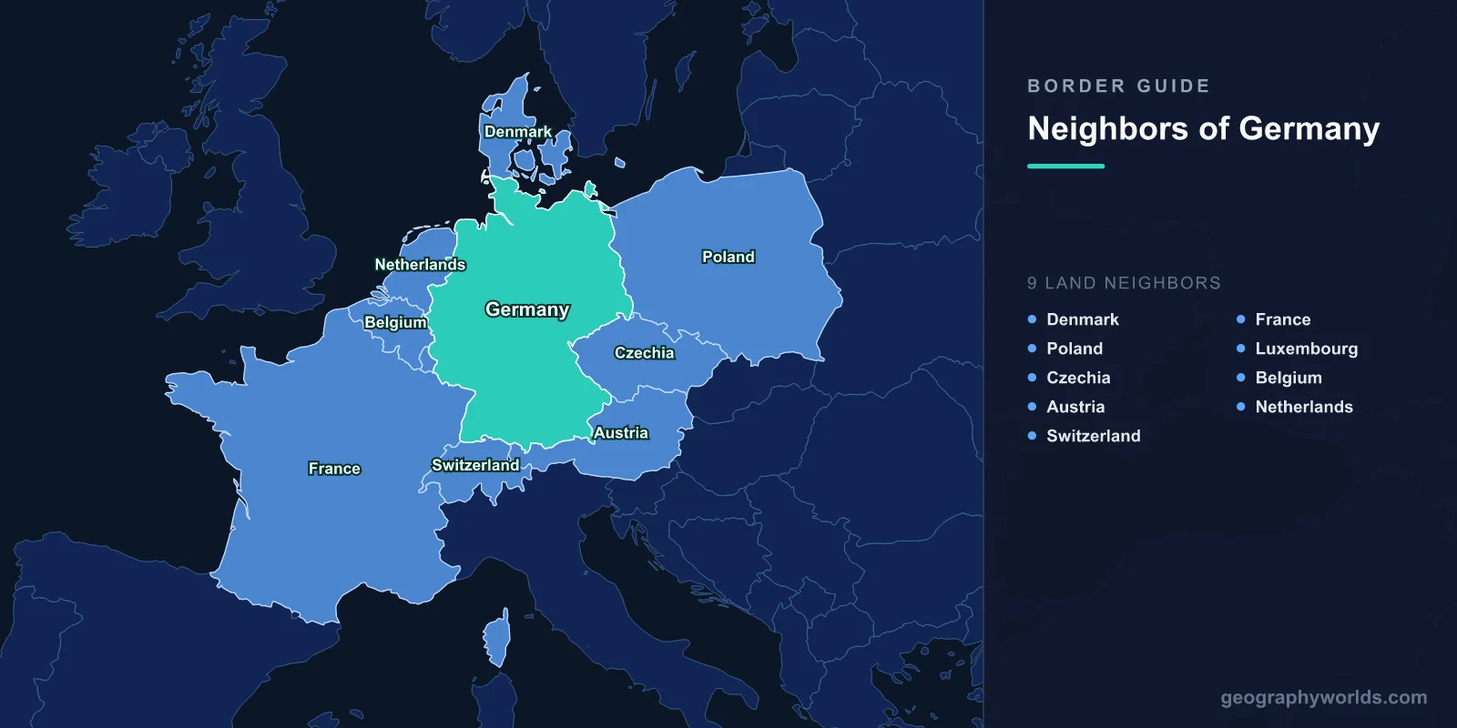
Going clockwise from the north, the order is Denmark, Poland, Czechia, Austria, Switzerland, France, Luxembourg, Belgium and the Netherlands. Germany's total land boundary is roughly 3,700 to 3,900 km, and the exact figure depends on the source. The CIA World Factbook gives a total of about 3,700 km. Germany's Federal Statistical Office (Destatis) gives a somewhat higher total and measures several individual borders differently. Much of the gap comes from how rivers and Lake Constance are measured.
| Neighbour | Approx. border length | Main feature along the line |
|---|---|---|
| Denmark | ~68–140 km | Jutland peninsula, 1920 plebiscite line |
| Poland | ~440–470 km | Oder and Lusatian Neisse rivers |
| Czechia | ~700–810 km | Ore Mountains, Bohemian/Bavarian Forest |
| Austria | ~800–820 km | Northern Alps, Inn and Salzach rivers |
| Switzerland | ~315–350 km | Lake Constance, High Rhine |
| France | ~420–450 km | Upper Rhine, Palatinate Forest/Northern Vosges |
| Luxembourg | ~130–135 km | Moselle, Sauer and Our rivers |
| Belgium | ~135–160 km | High Fens and Eifel/Ardennes uplands |
| Netherlands | ~565–575 km | Lowland plain, Rhine, Ems estuary |
Ranges reflect the difference between CIA World Factbook and German official measurements. The Denmark figure varies most, from about 68 km in German figures to about 140 km in the Factbook.
The Northern Frontier: Denmark and the 1920 Schleswig Line
Denmark
Germany's only northern land neighbour is also its shortest border by most measures. The line crosses the base of the Jutland peninsula from the Flensburg Fjord on the Baltic side to the Wadden Sea coast near the island of Sylt. It is not based on any physical feature. It was drawn by vote: after the Treaty of Versailles, the Duchy of Schleswig held two plebiscites in February and March 1920. The northern zone voted to join Denmark and the central zone, including Flensburg, voted to stay German, and the border has run between them ever since.
Minorities remain on both sides. A Danish-speaking community lives around Flensburg, where the Danish minority party, the SSW, is exempt from the 5% threshold in the Schleswig-Holstein state parliament. A German-speaking minority lives in North Schleswig. The main crossing is on the E45 motorway at Ellund/Frøslev, with the old road crossing at Kruså and Padborg nearby. In 2019 Denmark built a fence about 70 km long along much of the border to keep out wild boar carrying African swine fever.
The Eastern Rivers: Poland and the Oder–Neisse Line
Poland
Travelling east and then south, the border with Poland follows two rivers almost the whole way: the Oder (Odra) and its tributary the Lusatian Neisse (Nysa Łużycka). This is the Oder–Neisse line, set at the Potsdam Conference in 1945, which moved Poland roughly 200 km west at the expense of the former German provinces of Silesia, Pomerania and East Brandenburg. At its northern end the line leaves the Oder to put Szczecin (formerly Stettin) and Świnoujście on the island of Usedom inside Poland, which is why Usedom is split between the two countries.
Recognition came slowly. East Germany accepted the line in the Treaty of Zgorzelec in 1950. West Germany did so, with reservations, in the Treaty of Warsaw in 1970. Final recognition came only with reunification: the Two Plus Four Treaty of September 1990 required it, and the German–Polish Border Treaty of 14 November 1990 confirmed it. The river created divided twin towns: Frankfurt (Oder) and Słubice, Guben and Gubin, and Görlitz and Zgorzelec, which were once a single city on both banks of the Neisse. For the full picture from the Polish side, see the countries that border Poland.
Mountain Borders to the South-East: Czechia and Austria
Czechia
The Czech border is mostly a mountain border. It separates Saxony and Bavaria from Bohemia and follows the old Bohemian frontier, one of the most stable lines in Europe. Along Saxony it runs over the crest of the Ore Mountains (Erzgebirge/Krušné hory), whose mining landscape became a joint German–Czech UNESCO World Heritage Site in 2019. The Elbe crosses the border through the Elbe Sandstone Mountains between Schmilka and Hřensko, and Hřensko, at about 115 m, is Czechia's lowest point. Further south the line follows the Bavarian Forest and the Šumava (Bohemian Forest), protected on both sides by national parks.
Austria
Austria has Germany's longest border by most counts, around 800 km. West of Salzburg it climbs into the Northern Limestone Alps, and it crosses the summit area of the Zugspitze, which at 2,962 m is Germany's highest point and is shared with Tyrol. To the east, the Salzach and Inn rivers form the line. Simbach am Inn faces Braunau am Inn across the Inn, and Freilassing is effectively a suburb of Salzburg. The Austrian side also has two geographic oddities. The Kleinwalsertal valley belongs to Austria but can only be reached by road from Oberstdorf in Germany. The Tyrolean village of Jungholz is connected to the rest of Austria at a single point on the Sorgschrofen summit.
Lake Constance and the High Rhine: Switzerland
Switzerland
The Swiss border begins in Lake Constance (Bodensee), where Germany, Austria and Switzerland meet on the water without any agreed boundary. Switzerland holds that the border runs along the middle of the lake. Austria's position is usually described as a condominium, meaning the open lake is shared. Germany has never formally stated a view, and the three states manage shipping and fishing by treaty instead. From the lake's western end the High Rhine forms most of the border as far as Basel, except where the canton of Schaffhausen, home of the Rhine Falls, extends north of the river.
Just east of Schaffhausen is Büsingen am Hochrhein, a German village of around 1,500 people entirely surrounded by Swiss territory. Since a 1967 treaty it has been part of the Swiss customs area, so residents mostly use the Swiss franc, and the village has both German and Swiss postcodes. It is one of Europe's best examples of enclaves and exclaves. The border ends at the Dreiländereck in Basel's Rhine harbour, where Germany, Switzerland and France meet midstream.
The Western Rhine and Moselle: France and Luxembourg
France
From Basel north to Lauterbourg, the Upper Rhine is the Franco-German border for roughly 180 km. North of that, the line leaves the river and runs through the wooded hills where the Palatinate Forest meets the Northern Vosges, then along the edge of Saarland. Few borders changed hands as often. Alsace and part of Lorraine became German in 1871, French in 1918, were annexed again in 1940, and became French again in 1945. The Saar was separated under French control after 1945 and joined West Germany on 1 January 1957, after a referendum in 1955. Today the Strasbourg–Kehl crossing is effectively one city: the Europe Bridge has carried road traffic since 1960, and in 2017 Strasbourg's tram line D was extended across the Rhine into Kehl.
Luxembourg
The Luxembourg border is made up entirely of rivers: the Moselle, the Sauer (Sûre) and the Our. Unusually, these border rivers are a condominium, a stretch of water under the joint sovereignty of both states rather than divided down the middle, an arrangement that goes back to the settlements of 1815–1816. At the southern end, the Luxembourg wine village of Schengen sits on the Moselle facing both Perl in Germany and the French border. On 14 June 1985 the Schengen Agreement was signed there aboard the river boat Princesse Marie-Astrid, and it later removed routine passport checks across much of Europe. The Schengen area's borders now run far beyond this small corner of the Moselle.
The Low Countries: Belgium and the Netherlands
Belgium
The Belgian border crosses the High Fens and the Eifel, the German continuation of the Ardennes uplands. The land on the Belgian side around Eupen, Malmedy and Sankt Vith was German until the Treaty of Versailles transferred it to Belgium in 1920. It is now home to Belgium's small German-speaking Community of roughly 80,000 people. The strangest detail is the Vennbahn, an old railway line from Aachen south into Luxembourg. Its trackbed was assigned to Belgium, and because the railway weaves in and out of German territory, it cuts off several small pockets of Germany. Five German enclaves are usually counted, including parts of Mützenich and Rückschlag. The rails have since been lifted and the route is now a cycle path, but the Belgian strip remains.
Netherlands
The Dutch border begins at the Vaalserberg (about 322 m), where Germany, Belgium and the Netherlands meet on the highest point in mainland Netherlands. From there it runs north across flat farmland. In Kerkrade and Herzogenrath the line follows the middle of a single street, the Nieuwstraat/Neustraße. The Rhine crosses into the Netherlands between Emmerich and Lobith. After the Second World War the Netherlands annexed small strips of German land, including Selfkant and Elten, in 1949, and returned most of them in 1963. The last section, the Ems estuary and Dollart bay on the North Sea, has never been formally divided. The Netherlands argues that the border follows the deep channel, while Germany has historically claimed most of the estuary. The Ems-Dollart Treaty of 1960 and a 2014 agreement set out how the water is managed without settling the line.
Nine Neighbours Compared with China, Russia and France
Nine is a lot in Europe but not a world record. China and Russia share the top spot with 14 land neighbours each. Russia's count includes Norway, Finland, Poland and Lithuania, the last two only via the Kaliningrad exclave. Brazil comes next with 10. Austria and Serbia have eight each, and Hungary and Ukraine seven.
France is the closest comparison, and the answer depends on how you count. In Europe, France borders eight countries: Belgium, Luxembourg, Germany, Switzerland, Italy, Monaco, Andorra and Spain. Add its overseas territories and the count rises. French Guiana borders Brazil and Suriname, and Saint Martin shares an island with Dutch Sint Maarten, making 11 in total. France's longest border is not in Europe at all: it is the roughly 730 km line with Brazil. Germany's nine neighbours are all joined to it overland in one block, with its longest border against Austria. Of the nine, eight are EU members. Switzerland is not, but all nine are in the Schengen area, so most of Germany's 3,700-plus kilometres of frontier can be crossed without stopping. For how this ranks worldwide, see the list of countries with the most borders, where China and Russia sit at the top.