
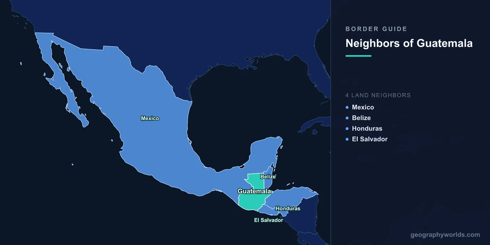
Guatemala shares land borders with four countries: Mexico to the north and west, Belize to the east, and Honduras and El Salvador to the south-east. It also has two coastlines, on the Pacific and, through a short stretch on the Gulf of Honduras, on the Caribbean. The Mexican border is by far the longest at roughly 960 kilometres; the El Salvador border, at around 200, is the shortest. And one of those four neighbours is a country Guatemala spent most of the twentieth century claiming as its own.
The Claim to Belize
Guatemala's claim rests on inheritance from Spain and on a treaty that was never fully performed. Under the Anglo-Guatemalan Treaty of 1859, Guatemala recognised the boundaries of British Honduras, and Britain undertook to contribute to building a road from Guatemala City to the Caribbean coast.
The road was never built. Guatemala subsequently argued that Britain's failure voided the treaty, and therefore voided the boundary recognition with it, reviving the Spanish colonial claim. From the 1940s Guatemalan constitutions and school maps showed Belize as a Guatemalan department, and the claim delayed Belizean independence for years, since Britain would not withdraw without security guarantees.
Belize became independent in 1981 with British troops remaining as a deterrent. Guatemala recognised Belize as a state in 1991 but did not drop the territorial claim, which today covers a substantial southern portion of the country.
Both Countries Voted to Go to Court
The two governments agreed in 2008 to submit the dispute to the International Court of Justice, subject to referendums in both countries. Guatemala voted yes in April 2018; Belize voted yes in May 2019, after an initial postponement over a legal challenge.
Guatemala filed its case in 2019, Belize responded, and the proceedings have continued since through written pleadings. A judgment will determine sovereignty over roughly half of Belize's land area along with a number of islands and maritime zones.
Meanwhile the two states manage the frontier through an Adjacency Zone, a strip one kilometre either side of the line, monitored under an Organization of American States framework with an office at the border. Incidents in the zone — over illegal logging, gold panning in the Sarstoon river and the movement of Guatemalan farmers into Belizean protected areas — are reported to the OAS rather than escalated.
The Sarstoon, and Where the Line Actually Runs
The southern boundary between the two countries follows the Sarstoon river, and the sovereignty question there is unusually literal: Guatemala maintains that the entire river is Guatemalan, while Belize asserts rights on it as a boundary waterway.
Belizean patrol boats and civilian activists have been turned back by the Guatemalan navy on several occasions, producing periodic diplomatic protests. Sarstoon Island at the mouth is claimed by both. It is a small dispute in area and a large one in principle, because it prefigures what the court will be asked to decide.
Mexico, and the Border That Became Everyone's Business
Guatemala's longest frontier runs with the Mexican states of Chiapas, Tabasco, Campeche and Quintana Roo, following the Suchiate river in the west and the Usumacinta in the north with straight survey lines between.
The crossing at Tecún Umán and Ciudad Hidalgo is the main formal point, and for decades the informal method has been the rafts: inner tubes lashed under wooden pallets, poled across the shallow Suchiate within sight of the official bridge, carrying passengers and goods for a small fee. The rafts operate openly and are a functioning part of the local economy.
The border's character changed when it became the first line of United States migration policy. Mexico's Programa Frontera Sur from 2014, and the deployment of the National Guard to the southern border under US tariff pressure in 2019, turned the Guatemalan frontier into an enforcement zone for a country 2,000 kilometres away.
The Refugees Who Went the Other Way
Movement across the Mexican border has not always run north for economic reasons. During Guatemala's civil war, which lasted from 1960 to 1996 and killed around 200,000 people, the army's counter-insurgency campaign in the western highlands destroyed hundreds of indigenous villages.
Around 200,000 Guatemalans, overwhelmingly Maya, fled into Chiapas, where camps were established and many remained for over a decade. A negotiated return programme in the 1990s brought large numbers home; others stayed and were eventually granted Mexican residence. A truth commission later found that the army's campaign in several highland regions constituted acts of genocide against Maya groups.
The Maya World Ignores All Four Lines
Guatemala's borders cut through a cultural region far older than any of them. The Maya area spans southern Mexico, all of Belize, Guatemala, western Honduras and El Salvador, and its great cities were distributed across what are now five jurisdictions.
Tikal, in Guatemala's northern Petén, was a dominant power in the Classic period; Calakmul, its principal rival, lies across the border in Mexican Campeche; Copán is in Honduras; Caracol in Belize. The Usumacinta river, now the Mexico-Guatemala boundary, was a highway rather than a barrier, with Yaxchilán and Piedras Negras facing each other across it.
Some 20 or more Mayan languages are spoken in Guatemala today, and communities extend across the Mexican line. The border is roughly 140 years old; the settlement pattern it cuts is several thousand.
Honduras, Copán and a Short Caribbean Coast
The Honduran border runs through mountainous country in the east and reaches the sea at the Gulf of Honduras, where Guatemala's Caribbean frontage is only about 150 kilometres long — but it holds Puerto Barrios and Santo Tomás de Castilla, the country's Atlantic ports and its access to Europe and the eastern United States.
The two countries share a maritime dispute in the gulf involving Belize as well, and they took the practical route: in 2021 Guatemala, Honduras and Belize agreed arrangements over the overlapping waters rather than litigating them.
Copán, just inside Honduras, is the Maya city most associated with sculptural achievement, and its position a few kilometres from the border makes it a standard excursion from Guatemala — an example of a heritage site whose visitor economy depends on an open frontier.
The CA-4, and a Border You Can Cross Without a Stamp
Guatemala, El Salvador, Honduras and Nicaragua operate the Central America-4 agreement, which allows their citizens to move among the four countries without passports or formal immigration procedures, using national identity cards.
In practice this creates a single zone of free movement across three of Guatemala's four borders, with the Mexican and Belizean frontiers as the controlled ones. It has facilitated a large regional labour market and, inevitably, the movement of gangs and contraband; the MS-13 and Barrio 18 networks operate across all four states, and their members move as easily as anyone else.
El Salvador, the Shortest and the Quietest
The El Salvador border is Guatemala's shortest and least eventful, running through the southern volcanic highlands and reaching the Pacific near the Paz river.
The two countries formed a customs union with Honduras in the late 2010s, integrating procedures at several crossings so that trucks clear once rather than at each frontier. Freight times fell substantially where it was implemented, which is the sort of unglamorous border reform that changes more than most treaties.
Volcanoes, and the Line Along the Sierra Madre
The Sierra Madre runs parallel to the Pacific coast and continues across the Mexican border, and Guatemala's volcanic chain includes Tajumulco, at 4,220 metres the highest point in Central America, and Fuego, one of the most consistently active volcanoes in the Americas.
Guatemala's Pacific coastline is around 250 kilometres of black volcanic sand. The country's two coasts are separated by less than 250 kilometres at the narrowest, which has periodically prompted proposals for a dry canal — a rail or road land bridge between the oceans — none of which has been built.
The Petén, and a Border Through Forest
Guatemala's northern department, the Petén, accounts for roughly a third of the country's area and holds a small fraction of its population. It is low, hot, forested limestone country, and it shares borders with both Mexico and Belize.
The Maya Biosphere Reserve covers much of it and connects across both frontiers to Mexico's Calakmul reserve and Belize's protected areas, forming the Selva Maya — the largest continuous tropical forest in the Americas north of the Amazon.
It is also among the least governed parts of Central America. Cattle ranching for money laundering, illegal logging, clandestine airstrips and looting of archaeological sites all operate in the reserve, and the border's remoteness is the enabling condition. Community forest concessions in the Petén, in which local cooperatives hold logging and management rights, have produced measurably lower deforestation than the strictly protected zones, and are cited internationally as evidence that people living in a forest can be better custodians than a fence.
Four Borders and a Pending Judgment
What distinguishes Guatemala among its neighbours is that one of its four boundaries is genuinely unresolved in law and has been submitted for judicial determination, while the other three function normally.
Whatever the court decides, the outcome will be one of the most significant territorial rulings in the Americas in decades. It will also test whether the pattern set in the Bakassi and Aouzou cases — losing states complying with adverse judgments — holds in a region with its own history of ignoring them. A fuller account is in our Guatemala country guide, and how many countries are in Central America sets out the region these four neighbours belong to.
