
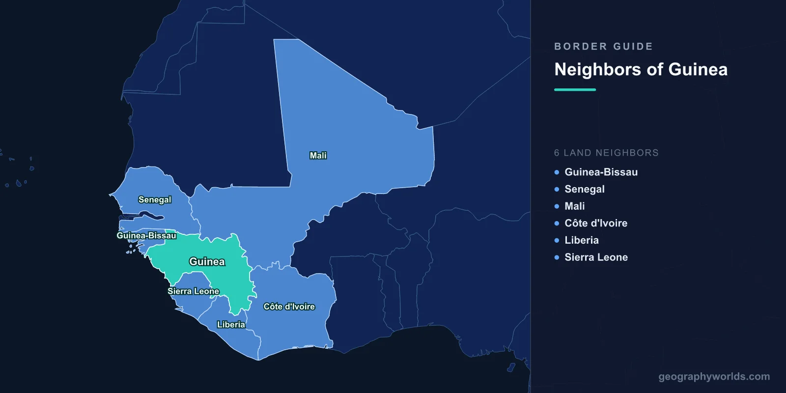
Guinea shares land borders with six countries: Guinea-Bissau and Senegal to the north-west, Mali to the north and north-east, Ivory Coast to the east, and Liberia and Sierra Leone to the south. It has around 320 kilometres of Atlantic coastline. Its borders total roughly 4,000 kilometres, and what makes them consequential is not their length but their altitude: the Fouta Djallon highlands inside Guinea are the source of the rivers that much of West Africa depends on.
The Water Tower of West Africa
Three major rivers rise in Guinea. The Niger, which runs 4,200 kilometres through Mali, Niger, Benin and Nigeria to the Atlantic, begins in the Guinea Highlands only about 240 kilometres from the sea and then turns inland. The Senegal river system rises in the Fouta Djallon, as does the Gambia.
The implication is that decisions taken in Conakry about dams, irrigation and deforestation have downstream effects in a dozen countries. Guinea joined the Senegal river basin organisation, the OMVS, in 2006 for precisely that reason — a basin authority that excluded the headwaters made no sense — and it is a member of the Niger Basin Authority.
The Fouta Djallon itself is a sandstone massif of plateaux and deep valleys, wetter and cooler than the lowlands around it, and historically the seat of a Fulani imamate that was one of the most organised states in eighteenth-century West Africa.
The Bauxite Under the Border Regions
Guinea holds the world's largest bauxite reserves, and the mines of the Boké region in the north-west, near the Guinea-Bissau frontier, supply a very large share of global aluminium production, much of it to China.
In the south-east, close to the Liberian border, the Simandou range holds one of the largest untapped high-grade iron ore deposits on earth. Developing it required a railway of more than 600 kilometres to a new port, a project whose cost and complexity kept it stalled for decades and which finally moved toward production in the 2020s.
Simandou's history is a case study in how a border-adjacent resource attracts trouble: concession rights were revoked, reallocated and litigated across several jurisdictions, and a related corruption case produced convictions abroad. An alternative route through Liberia to the port at Buchanan was repeatedly proposed as cheaper and repeatedly rejected in Conakry on the grounds that the ore should leave through Guinea.
Saying No to France
Guinea's borders were shaped by a single decision in 1958. Offered membership of a French Community in a referendum, Guinea alone among France's African territories voted no, and Ahmed Sékou Touré declared that Guineans preferred poverty in freedom to riches in slavery.
France withdrew abruptly and comprehensively, taking equipment, destroying records and cutting aid. Guinea turned to the Soviet bloc, and its relations with French-aligned neighbours — Ivory Coast and Senegal in particular — were hostile for years, with borders closed and exiles hosted on both sides.
The isolation shaped the country's infrastructure. Guinea's roads and railways were built to serve mines and the capital rather than to connect with neighbours, and the regional integration that ECOWAS later encouraged started from a low base here.
The Parrot's Beak
At the southern end, Guinea's territory projects into a salient between Sierra Leone and Liberia known as the Parrot's Beak — the Guéckédou and Kissidougou region, where the three countries meet.
During the Sierra Leonean and Liberian civil wars of the 1990s, this area absorbed enormous numbers of refugees; at points Guinea hosted several hundred thousand people, among the largest refugee populations in Africa, in one of its poorest regions.
In 2000 and 2001 the war came the other way. Forces linked to the Revolutionary United Front and to Charles Taylor's Liberia attacked into the Parrot's Beak, striking border towns and the refugee camps themselves. Guinean forces, with substantial popular mobilisation, repelled them over several months of fighting that displaced hundreds of thousands more.
Where the Ebola Epidemic Started
The West African Ebola epidemic of 2014 to 2016, which killed more than 11,000 people, began in this same border region. The index case was a young child in the village of Meliandou in Guéckédou prefecture, in December 2013.
The outbreak spread rapidly into Sierra Leone and Liberia because the frontier there is dense with movement: weekly markets serving all three countries, funerals attended by relatives across the line, and families divided by boundaries that mean little locally.
It took three months for the disease to be identified, by which time it had crossed both borders. The epidemic became the central argument for regional disease surveillance in West Africa, and for the principle that an outbreak at a tri-border point is by definition a regional emergency.
Yenga
Guinea and Sierra Leone have an unresolved dispute over Yenga, a small village on the Makona river at the eastern end of their boundary. Guinean forces entered it during the Sierra Leone civil war, with Freetown's agreement, to help secure the frontier against the RUF, and did not leave when the war ended.
Sierra Leone maintains the village is on its side of the boundary established in an Anglo-French agreement of 1912; Guinea has at various points acknowledged this and at others maintained a presence. Successive joint declarations — in 2005, 2012 and since — have affirmed Sierra Leonean sovereignty and provided for demilitarisation, and the matter has repeatedly drifted.
It is a very small dispute, involving a village of a few hundred people, and it has persisted for more than two decades precisely because it is too small for either government to spend political capital on.
Mount Nimba, Shared Three Ways
Where Guinea, Liberia and Ivory Coast meet stands Mount Nimba, a range rising above the surrounding forest and holding species found nowhere else, including a toad that gives birth to live young rather than laying eggs.
The Mount Nimba Strict Nature Reserve is a UNESCO World Heritage site spanning Guinea and Ivory Coast, inscribed in the 1980s and placed on the danger list after a Guinean concession excised part of the property for iron ore mining and after refugee settlement pressed on its boundaries.
It remains one of the clearest examples of a protected area whose integrity depends on three governments and whose mineral value keeps testing their commitment.
Guinea-Bissau, and a Maritime Line at Arbitration
The north-western border with Guinea-Bissau runs through mangrove and river country. Its offshore extension was disputed, and the two states submitted the question to arbitration; a tribunal issued an award in 1985 fixing the maritime boundary.
The two countries subsequently agreed on joint management of resources in parts of the zone rather than pressing further. Guinea-Bissau, meanwhile, had its own separate and longer-running maritime disagreement with Senegal on its northern side, resolved through a different arbitration and then a joint exploitation agency — leaving that stretch of coast unusually well covered by shared-resource arrangements.
Mali, and the Trade That Goes Both Ways
The border with Mali runs north-east from the Fouta Djallon into the Sahelian plains, and the road from Conakry to Bamako carries a meaningful share of landlocked Mali's imports, offering an alternative to the Dakar and Abidjan corridors.
That alternative became valuable in 2022, when ECOWAS sanctions closed Malian borders with several member states. Guinea, itself suspended from ECOWAS after its own 2021 coup, declined to close its frontier, and the Conakry corridor carried traffic that could not move any other way.
It was an unusual case of two states under regional sanctions finding that their shared border had become an asset.
Conakry, and a Capital on a Point
Guinea's capital occupies the Kaloum peninsula, a narrow finger of land projecting into the Atlantic, and the city has grown inland along it for tens of kilometres because there is nowhere else to go. Everything — the port, the government, the commercial centre — sits at the tip, so the whole population commutes along a single congested axis.
That geography has political consequences. Blocking one road can isolate the government quarter, which is why Conakry's periodic upheavals have been concentrated on a handful of junctions, and why the 2008 and 2021 coups were settled quickly once particular buildings were held.
It also constrains the country's trade. For a state holding the world's largest bauxite reserves and one of its largest iron ore deposits, port capacity on a silted, mangrove-fringed coast has been the persistent bottleneck, and the mining companies have built their own dedicated terminals rather than use the national one.
A Coast of Mangroves
Guinea's Atlantic frontage is shallow, muddy and fringed with some of the most extensive mangrove forest in West Africa, which is why the country has no great natural harbour and why Conakry sits on a peninsula with a port that has needed continual dredging and expansion.
The Îles de Los offshore were British until 1904, when they were transferred to France in the settlement that also dealt with Newfoundland fishing rights and Egypt — a reminder that borders in this region were traded in packages negotiated thousands of kilometres away.
Six land neighbours, the headwaters of three great rivers, the world's largest bauxite reserves and one of its largest iron ore deposits: Guinea's frontiers enclose more of what the region needs than any comparable country, which has been as much a burden as an advantage. Guinea in wider terms is our Guinea country guide, and our Niger river guide follows the waterway that begins in its highlands.
