
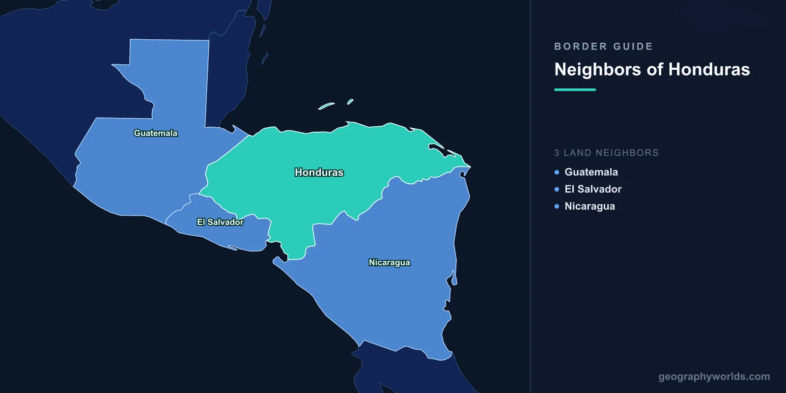
Honduras shares land borders with three countries: Guatemala to the west, El Salvador to the south-west, and Nicaragua to the south-east. It has a long Caribbean coastline of roughly 650 kilometres and a very short Pacific one — around 150 kilometres, all of it inside the Gulf of Fonseca, a body of water it shares with two of those three neighbours under an arrangement almost unique in international law.
The Hundred-Hour War
In July 1969 Honduras and El Salvador fought a war lasting just over four days. It is universally remembered as the Football War, because the fighting followed a bad-tempered series of World Cup qualifying matches between the two national teams, complete with rioting fans and severed diplomatic relations.
The football was the trigger, not the cause. El Salvador was small and densely populated with land concentrated in few hands; Honduras was larger and emptier. Over decades, perhaps 300,000 Salvadorans had crossed to farm in Honduras, many without title.
In 1969 Honduras enacted a land reform that redistributed land to Honduran peasants and expelled Salvadoran squatters, and tens of thousands were forced back across the border, arriving in a country with nowhere to put them. The Salvadoran army invaded on 14 July. The Organization of American States arranged a ceasefire within days, and around 3,000 people, mostly Honduran civilians, were killed.
The consequences outlasted the war. The Central American Common Market was effectively destroyed, the border stayed closed for a decade, and the land pressures in El Salvador that produced the migration in the first place contributed directly to its civil war in the following decade.
The Bolsones
A peace treaty in 1980 restored relations and referred the boundary to the International Court of Justice. Six sections of the land frontier — known as bolsones, pockets — remained in dispute, along with islands in the Gulf of Fonseca and the status of the gulf itself.
The court's judgment in September 1992 was one of the most comprehensive territorial rulings it has issued. It applied uti possidetis juris to Spanish colonial administrative boundaries as they stood in 1821, divided the six land sectors between the parties, and assigned the disputed islands: El Tigre to Honduras, Meanguera and Meanguerita to El Salvador.
El Salvador sought revision of the judgment in 2002, arguing that newly discovered documents changed the position on one sector. The court rejected the application in 2003. Demarcation of the land boundary proceeded slowly through the following decades, with the practical problem that people living in the transferred pockets had to choose a nationality.
A Gulf Held in Common
The most unusual part of the 1992 judgment concerned the Gulf of Fonseca itself. The court held that the gulf is a historic bay, that its waters — outside a narrow coastal belt belonging to each state — are held in joint sovereignty by Honduras, El Salvador and Nicaragua together, as successors to the Spanish Crown.
Condominium over a body of water shared by three states is rare to the point of near-uniqueness in modern international law. It means fishing, navigation and security in the gulf are matters for all three, and the arrangement has required a trilateral commission that has functioned with varying enthusiasm.
It has not eliminated disputes. Conejo Island, occupied by Honduras, is claimed by El Salvador and was not addressed in the judgment, and the three states have periodically reopened questions of access and maritime delimitation beyond the closing line of the gulf.
The gulf is also Honduras's only Pacific outlet, which gives the arrangement real economic weight: the port of San Lorenzo depends on it, as does Honduran shrimp farming.
The Coco River, and a King of Spain
The Nicaraguan border largely follows the Coco river, also called the Segovia, the longest river in Central America. Its course was fixed by an arbitral award issued in 1906 by King Alfonso XIII of Spain, acting as arbitrator under a treaty between the two countries.
Nicaragua accepted the award at the time and then repudiated it decades later, arguing it was invalid. Honduras took the matter to the International Court of Justice, which held in 1960 that the award was binding and must be carried out. Nicaragua complied, and the boundary was demarcated in the 1960s.
The maritime extension into the Caribbean was settled separately, by an ICJ judgment in 2007 that drew a bisector line and confirmed Honduran sovereignty over four small cays. Both states accepted it. Between them, Honduras and Nicaragua have taken more boundary questions to international adjudication than almost any other pair in the hemisphere — and have complied with the outcomes.
The Mosquito Coast
The eastern end of the Nicaraguan border runs through the Mosquitia, the sparsely populated Caribbean lowland of swamp, savanna and rainforest that spans both countries. It is the home of the Miskito, who maintained an autonomous kingdom under British protection into the nineteenth century and were never effectively incorporated by either Spanish colonial administration.
Miskito communities straddle the Coco river, and families routinely have members on both sides. During the 1980s the border became a war zone: Miskito groups took up arms against the Sandinista government after forced relocations, and operated from Honduran territory alongside the wider contra forces supplied through Honduras.
Honduras's Río Plátano Biosphere Reserve, a UNESCO World Heritage site covering a large part of the Mosquitia, is one of the largest remaining rainforest blocks in Central America and has been listed as in danger because of illegal cattle ranching, logging and the use of clandestine airstrips by traffickers.
Guatemala, Copán and a Customs Union
The western border with Guatemala runs through mountainous country and reaches the Caribbean at the Gulf of Honduras. Just inside Honduras sits Copán, the Maya city celebrated for its sculpture and its hieroglyphic stairway, a few kilometres from the line and visited largely by travellers based in Guatemala.
The two countries, later joined by El Salvador, formed a customs union from 2017, integrating procedures so that freight clears once rather than at each border. Transit times fell substantially, and it stands as the most concrete piece of Central American integration achieved in decades — notable given that the last serious attempt was destroyed by the 1969 war.
The maritime situation in the Gulf of Honduras involves Guatemala, Honduras and Belize in overlapping claims, complicated further by Guatemala's unresolved case against Belize.
The CA-4 and Free Movement
Honduras, Guatemala, El Salvador and Nicaragua operate the Central America-4 agreement, allowing their citizens to move among the four states on national identity cards without passports or formal immigration control.
It has created a genuine regional labour market and, unavoidably, eased the movement of criminal networks. MS-13 and Barrio 18 operate across all four countries, and the gangs' transnational structure is partly a product of deportations from the United States in the 1990s that returned members to countries they barely knew.
A Corridor for Somebody Else's Trade
Honduras's borders sit on the cocaine route between South America and the United States. Shipments arriving by sea and air on the Caribbean coast move overland north through Guatemala and Mexico, and the Mosquitia's remoteness makes it ideal for the purpose.
The consequences for the Honduran state have been severe, culminating in the conviction in a United States court of former president Juan Orlando Hernández on drug trafficking charges in 2024. Homicide rates in the border departments and in San Pedro Sula reached among the highest recorded anywhere in the 2010s.
That insecurity is a principal driver of the migrant caravans that have departed from San Pedro Sula since 2018, travelling north through Guatemala and Mexico — a movement that crosses two of Honduras's three borders in its first two days.
The Bay Islands, and a Different Honduras
Off the Caribbean coast lie Roatán, Utila and Guanaja, the Bay Islands, which were British until 1859 and have a population historically English-speaking, Protestant and of mixed African and European descent, quite distinct from the Spanish-speaking mainland.
Britain ceded them to Honduras by treaty, on conditions protecting the inhabitants' religion and property. The islands sit on the Mesoamerican Barrier Reef, the second-largest reef system in the world, which runs north from Honduras along the coasts of Guatemala, Belize and Mexico — an ecological structure crossing four maritime jurisdictions.
Their economy is diving tourism and cruise calls, and their cultural separateness from the mainland has periodically produced autonomy sentiment. They are a reminder that Honduras's borders were assembled from more than Spanish colonial administration.
Three Borders, Two Oceans, One Narrow Waist
Honduras's shape gives it an unusual position: a long Caribbean coast, a tiny Pacific one shared under condominium, and land borders with every one of its mainland neighbours except Belize.
The country has settled its land and maritime boundaries through international adjudication more thoroughly than most states anywhere, and has complied with the judgments. That legal orderliness sits alongside a security situation that the same borders have made very difficult to manage — which is a reasonable summary of the region as a whole. Honduras in the round is our Honduras country guide, and how many countries are in Central America sets out the neighbourhood it belongs to.
