
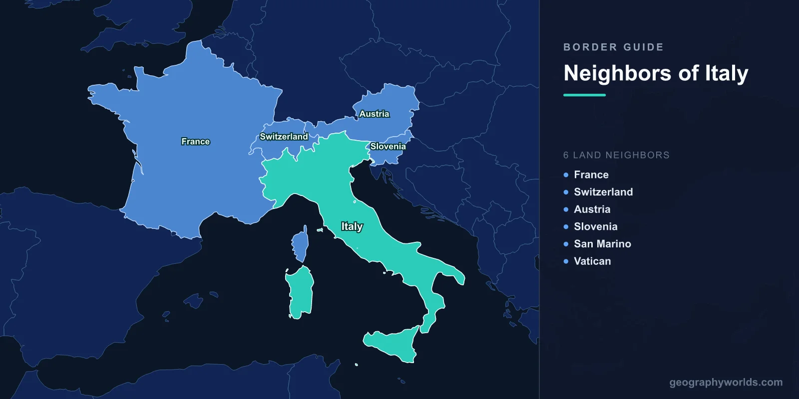
Italy shares land borders with 6 countries: France (488 km), Switzerland (698 km), Austria (404 km), Slovenia (218 km), San Marino (39 km), and Vatican City (3.4 km), totaling approximately 1,850 km of land boundaries. Four of these borders run through the Alps, while two enclose independent microstates entirely within Italian territory.
Introduction
The Italian peninsula extends deep into the Mediterranean Sea, but its northern boundary is defined by one of the most spectacular mountain ranges on Earth — the Alps. This great arc of peaks forms natural frontiers with France, Switzerland, Austria, and Slovenia. Within Italy itself, two of the world's smallest sovereign states — San Marino and Vatican City — maintain their independence as enclaves completely surrounded by Italian territory. Italy's borders reflect a complex history of unification, territorial adjustments after two world wars, and the unique survival of medieval microstates.

Complete List of Countries Bordering Italy
- Switzerland: 698 km
- France: 488 km
- Austria: 404 km
- Slovenia: 218 km
- San Marino: 39 km
- Vatican City: 3.4 km
Italy's borders span the entire Alpine arc from the French Riviera in the west to the Karst Plateau near Trieste in the east. The country also uniquely contains two sovereign microstates, making Italy one of only a few nations that completely surround other countries.
Alpine Borders: France, Switzerland, and Austria
- France border: 488 km — from the Mediterranean to Mont Blanc
- Switzerland border: 698 km — Italy's longest, through the central Alps
- Austria border: 404 km — runs through the Tyrol and Dolomites
The Italo-French border stretches 488 km along the western Alps, from the Mediterranean coast near Ventimiglia to the summit of Mont Blanc (4,808 m). The Mont Blanc Tunnel and Fréjus Road Tunnel are vital transport links. The border region includes the bilingual Aosta Valley, where French and Italian are both official languages.
Italy's longest border is with Switzerland at 698 km, weaving through the central Alps and the Italian-speaking Swiss canton of Ticino. Lake Lugano and Lake Maggiore straddle the border, and the Gotthard Base Tunnel — the world's longest railway tunnel at 57 km — connects the two countries beneath the Alps.
The Italo-Austrian border of 404 km runs through the spectacular Dolomites and Tyrol region. South Tyrol (Alto Adige), transferred from Austria to Italy after World War I, retains a German-speaking majority. The region enjoys broad autonomy, and the border area exemplifies how Alpine communities can transcend national boundaries.
Eastern Border: Slovenia
- Border length: 218 km — from the Alps to the Adriatic near Trieste
- Key feature: The Karst Plateau gives its name to "karst" geology worldwide
The Italy-Slovenia border extends 218 km from the Julian Alps to the Adriatic coast near Trieste. This region changed hands multiple times in the 20th century: the area around Trieste and Istria was hotly contested between Italy and Yugoslavia after both World Wars. The current border was finalized by the Treaty of Osimo in 1975. The city of Gorizia on the Italian side and Nova Gorica on the Slovenian side were divided by the border — often called a "mini Berlin Wall" — until Slovenia joined the Schengen Area in 2007, finally reuniting the communities.
Enclosed Microstates: San Marino and Vatican City
- San Marino border: 39 km — entirely surrounded by Italy in the Emilia-Romagna/Marche region
- Vatican City border: 3.4 km — enclosed within the city of Rome
San Marino claims to be the world's oldest surviving republic, founded in 301 AD. Perched on Mount Titano in north-central Italy, this microstate covers just 61 km² with a border of 39 km. Despite being entirely surrounded by Italy, San Marino maintains its own government, postal service, and even a small military.
Vatican City, at just 0.44 km² with a 3.4 km border, is the smallest independent state in the world. Enclosed entirely within Rome, it was established as a sovereign entity by the Lateran Treaty of 1929 between Italy and the Holy See. The border runs around St. Peter's Square and is one of the most visited international boundaries on Earth, crossed by millions of tourists and pilgrims each year.
Historical Border Changes
Italy's current borders are largely the result of the two World Wars. Before Italian unification in the 1860s-1870s, the peninsula was divided among multiple states. After World War I, Italy gained South Tyrol, Trieste, and Istria from Austria-Hungary. After World War II, Italy lost Istria and parts of the Julian March to Yugoslavia. The Free Territory of Trieste was divided between Italy and Yugoslavia in 1954, with the final border confirmed in 1975. San Marino and Vatican City represent remarkable survivals of much earlier political arrangements, having maintained their sovereignty through centuries of Italian power politics.
Key Facts
- Italy borders 6 countries — four along the Alps and two microstates within its territory
- The Switzerland border (698 km) is Italy's longest
- Vatican City's 3.4 km border with Italy is among the shortest in the world
- South Tyrol on the Austrian border has a German-speaking majority due to World War I territorial changes
- The Gotthard Base Tunnel (57 km) is the world's longest railway tunnel connecting Italy and Switzerland
Fun Facts
- Vatican City has the highest crime rate per capita in the world — mainly pickpocketing — because millions of tourists visit its tiny 0.44 km² territory annually.
- San Marino has more cars than people, with approximately 1.6 vehicles per citizen.
- Mont Blanc's exact summit position on the Franco-Italian border is disputed — France claims the border runs over the peak while Italy places it slightly to the French side.
- The town of Campione d'Italia is an Italian exclave surrounded by Switzerland, using Swiss francs and Swiss phone codes despite being Italian sovereign territory.
Final Thoughts
Italy's six borders span from the grandeur of the Alps to the heart of Rome. Each frontier tells a unique story — from the dramatic mountain passes connecting Italy to France, Switzerland, and Austria, to the Balkan complexities of the Slovenian border, to the remarkable persistence of the world's smallest sovereign states. Italy's borders are a living museum of European history and geography.
Test Your Knowledge!
Think you know your borders and boundaries? Try our interactive geography quiz!
Play Geography Games →