
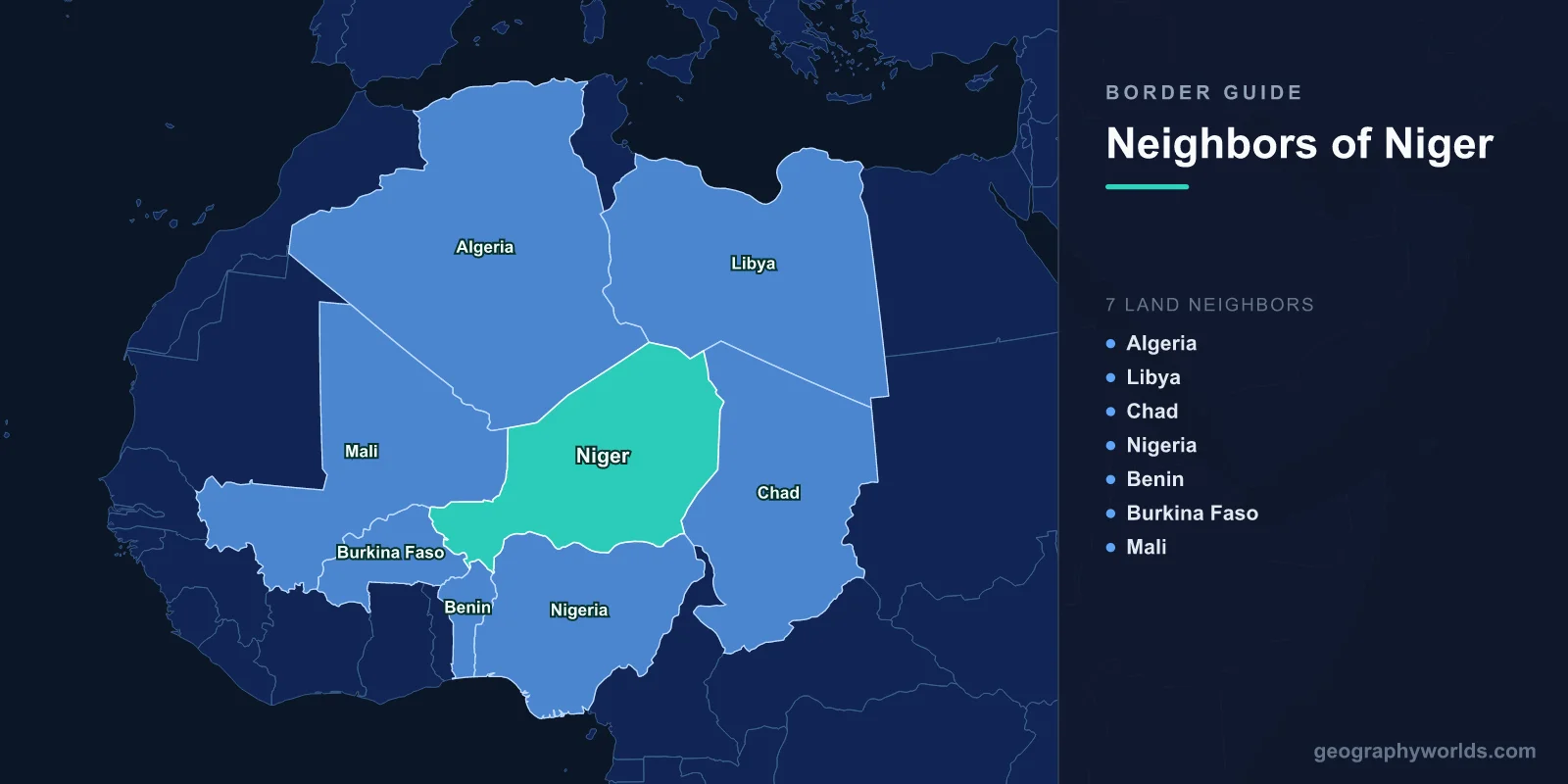
Niger shares land borders with seven countries: Algeria and Libya to the north, Chad to the east, Nigeria and Benin to the south, and Burkina Faso and Mali to the west. That is more neighbours than any other West African state, and none of them is a coastline. Niger is landlocked, roughly 80 per cent desert, and its 5,700 kilometres of frontier run from the Sahara down to the Niger river and the Sahelian farmland along the Nigerian line.
The North: Borders Drawn Across Emptiness
The Algerian and Libyan boundaries were fixed by French and Italian colonial agreement and run as long straight segments across the Ténéré and the Djado plateau. There are no rivers to follow and almost no settlements, so the surveyors used coordinates.
These lines are effectively unpoliceable in any conventional sense. The terrain is open in every direction, the distances are enormous, and control is exercised at chokepoints — wells, passes and the towns where vehicles must refuel — rather than along the boundary itself.
The frontier with Libya has been the more volatile of the two since 2011. The collapse of the Libyan state sent weapons south across it in quantity, arming groups across the Sahel, and returning Tuareg fighters who had served in Gaddafi's forces contributed directly to the rebellion that broke out in northern Mali in 2012.
Agadez and the Road North
For years the single most consequential border movement in Niger was migration. Agadez, the old Tuareg caravan city on the southern edge of the Sahara, became the assembly point for West Africans heading for Libya and then Europe, and convoys left weekly, piled onto pickups for the crossing to Sebha or Qatrun.
The trade was legal and substantial, employing drivers, fixers, guesthouse owners and mechanics across the city. In 2015, under considerable European pressure and with European funding, Niger passed Law 36, criminalising the transport of migrants north of Agadez.
Departures fell sharply and the local economy contracted. The routes did not close: they moved further from wells and roads, which made them more dangerous, and deaths in the desert rose. The law was repealed in 2023 by the military government that took power that year, in a decision aimed as much at Europe as at the smugglers.
Uranium, and a Border With Algeria
Niger is one of the world's significant uranium producers, and the mines at Arlit and Akokan sit in the northern desert not far from the Algerian frontier. French companies operated them for decades, and the ore has historically travelled south by road to Cotonou in Benin rather than north.
The mines have been a target. Al-Qaeda in the Islamic Maghreb kidnapped foreign workers at Arlit in 2010 and bombed the site in 2013, and the road convoy route has been attacked repeatedly. The northern borders matter to Niger's economy precisely because the country's most valuable export sits beside them.
The Nigerian Frontier Is the Real One
Niger's 1,600-kilometre boundary with Nigeria is the one that shapes daily life. On both sides live Hausa communities who share a language, a commercial culture and dense family ties, and the line between Kano state and the Niger regions of Maradi and Zinder cuts through what is functionally a single economic zone.
Trade across it is enormous and largely informal. Nigerian fuel, subsidised at source, flows north; Nigerien livestock, onions and cowpeas flow south to feed Nigerian cities. Exchange-rate movements between the naira and the CFA franc redirect the flows overnight, and the border towns are built around arbitrage.
The dependence runs deep enough to be a strategic vulnerability. When ECOWAS imposed sanctions after the July 2023 coup, Nigeria closed the border and cut electricity supplies on which Niger relied for a large part of its grid, and the effect on Niamey was immediate.
Where the River Comes In
The Niger river enters the country from Mali in the south-west, curves through Niamey and leaves into Nigeria. Only a modest stretch of the country lies along it, but that stretch holds the capital, most of the irrigated agriculture and a large share of the population.
The river is also a shared resource governed by the Niger Basin Authority, which links nine states. Upstream decisions in Mali and Guinea affect flow at Niamey, and the proposed Kandadji dam, intended to secure irrigation and power, has been decades in the making.
Benin, Burkina Faso, and a Tripoint at the Park
The south-western borders with Burkina Faso and Benin meet in the W-Arly-Pendjari complex, a transboundary protected area named for a bend in the Niger river shaped like the letter W. It is a UNESCO World Heritage site spanning all three countries and one of the last strongholds of West African savanna wildlife, including the region's remaining elephant and lion populations.
It has also become a base for armed groups. The park's remoteness, the absence of settlement and the meeting of three jurisdictions make it exactly the sort of place insurgents use, and rangers and tourists have been killed there. Several sections have been closed for years.
A Court Case Over River Islands
Niger and Benin disagreed for decades over roughly two dozen islands in the Niger river, most importantly Lété, a fertile island used for grazing and farming where clashes had caused deaths.
The two states submitted the dispute to the International Court of Justice, which ruled in 2005, allocating Lété and most of the larger islands to Niger and the remainder to Benin, on the basis of the main navigable channel and colonial-era administration. Both accepted the judgment, and the boundary was demarcated.
Relations across that border deteriorated sharply after 2023 for political rather than territorial reasons, with the frontier closed for extended periods, disrupting the route Nigerien uranium and general imports take to the port of Cotonou.
Mali, and the Three Borders Zone
The western frontier with Mali runs through the Sahel, and the point where Niger, Mali and Burkina Faso meet — the Liptako-Gourma region, usually called the three borders zone — has been the most violent place in the Sahel for much of the past decade.
Groups affiliated with al-Qaeda and with Islamic State operate across all three jurisdictions, exploiting the fact that pursuit stops at a line they ignore. Massacres of civilians, attacks on military posts and the displacement of hundreds of thousands have been concentrated here.
The G5 Sahel force was created to permit joint operations across these borders and effectively collapsed as its members left. In 2023 Mali, Burkina Faso and Niger, all under military governments, formed the Alliance of Sahel States and announced their withdrawal from ECOWAS — a realignment that turned three of Niger's seven borders into frontiers of a new and untested bloc.
Chad, and the Eastern Desert
The eastern boundary with Chad runs from the Libyan tripoint south through the desert to the Lake Chad basin. Like the northern lines it is largely a survey abstraction for most of its length.
At its southern end it reaches Lake Chad, where Niger, Nigeria, Chad and Cameroon meet in shrinking water and shifting islands. Niger's Diffa region, along that stretch, has absorbed large numbers of displaced people from the Boko Haram conflict and has suffered repeated attacks, and Niger contributes to the Multinational Joint Task Force created to allow forces to cross these borders in pursuit.
Seven Neighbours, No Coast
Being landlocked with seven neighbours means Niger's trade routes are political choices. The uranium road to Cotonou runs through Benin; general imports arrive through Lomé in Togo or through Nigeria; and each route can be closed by a government in a capital Niger does not control.
The events of 2023 demonstrated all of it at once — sanctions, a closed Nigerian border, a closed Beninese border, suspended electricity imports. For a country with an average of one neighbour for every 180,000 square kilometres of territory, the practical lesson was that seven borders is not seven options.
A Country Named After a River It Barely Touches
Niger takes its name from the river, and yet the Niger flows through only the south-western corner of the country, a stretch of a few hundred kilometres out of a total course of more than 4,000. The name arrived with French colonial administration rather than from any Nigerien usage, and it is shared with Nigeria, immediately south, which has the same origin and a rather better claim to it.
The word itself is not related to any Latin root for black, despite a persistent folk etymology. It most likely derives from a Tuareg phrase, egerew n-igerewen, meaning river of rivers, which is how the waterway is described where it passes through the desert — the only reliable water in an enormous dry country.
The Desert Is Not Empty
It is easy to describe Niger's northern borders as running through nothing. They do not. The Tuareg, Toubou and Arab communities of the north have used these routes for centuries, and the trans-Saharan salt caravans from Bilma to Agadez still run, with camels carrying salt and dates south along a route older than any of the states involved.
Those communities' relationship with the capital has been the country's other long-running conflict, producing Tuareg rebellions in the 1990s and again in 2007. Any account of Niger's borders that treats the north as a blank is repeating the mistake that produced those rebellions. Niger in full is our Niger country guide; the terrain its northern lines cross is described in the geography of the Sahara, and the water the country is named after is traced in our Niger river guide.
