
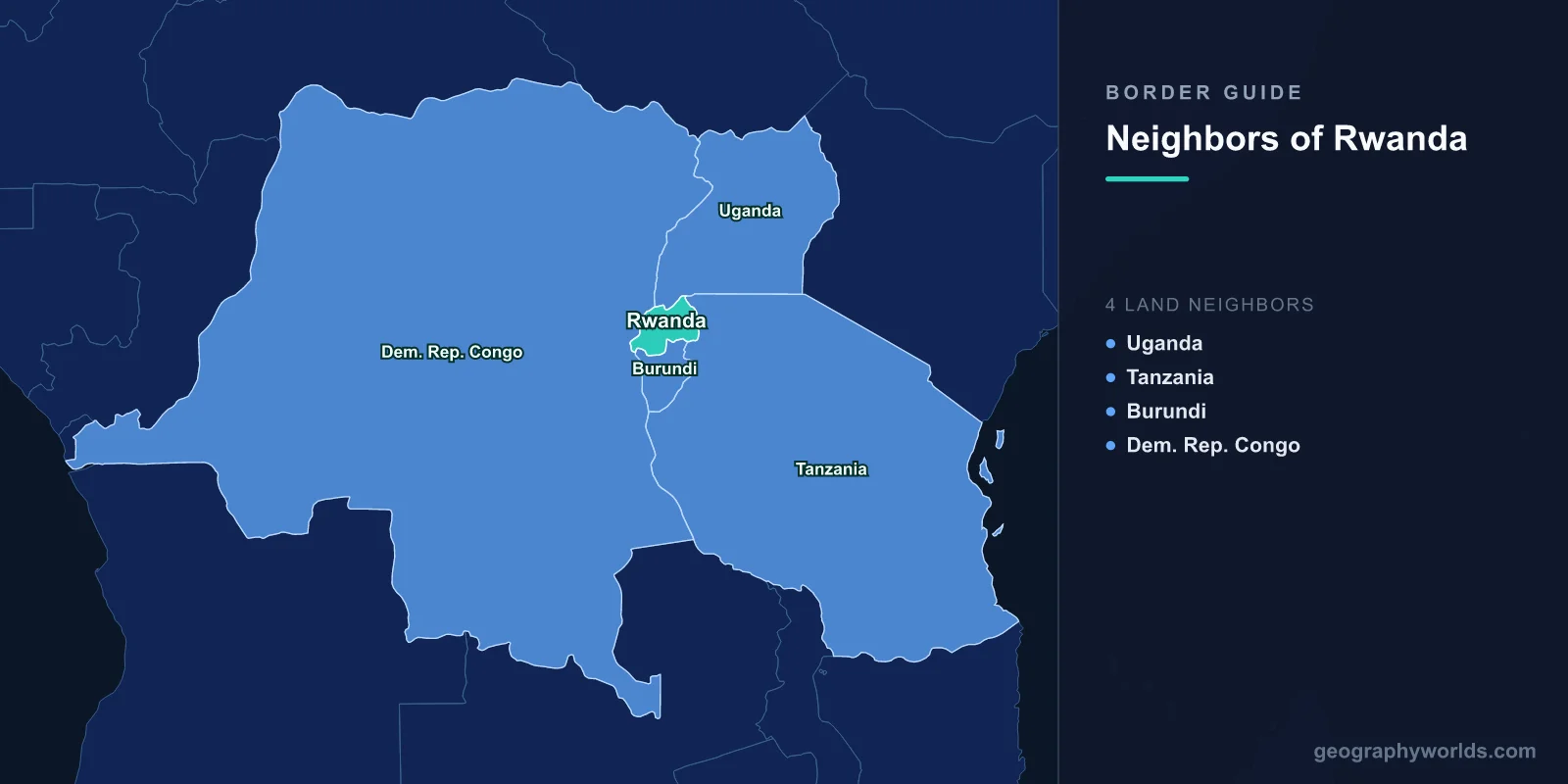
Rwanda shares land borders with four countries: Uganda to the north, Tanzania to the east, Burundi to the south, and the Democratic Republic of the Congo to the west. The total frontier runs only about 930 kilometres, because Rwanda is small — roughly 26,000 square kilometres, about the size of Belgium — and landlocked, more than 1,000 kilometres from the nearest port. For a country that size, its borders have generated an extraordinary amount of history.
The Border That Runs Through a City
At the northern end of Lake Kivu, the Rwandan town of Gisenyi and the Congolese city of Goma form a single continuous built-up area divided by a border post. People cross to work, to shop, to attend school and to see family, and the crossing at the Grande Barrière handles very large numbers each day.
Goma is much the larger of the two, and its economy has long been oriented as much toward Kigali as toward Kinshasa, which is more than 1,500 kilometres away across the forest. Rwandan goods, Rwandan traders and Rwandan services operate in Goma as a matter of routine, and the political question of Rwandan influence in eastern Congo is inseparable from that everyday reality.
The border is also geologically dramatic. Nyiragongo, an active volcano with a persistent lava lake, sits directly above Goma. Its eruption in January 2002 sent lava through the centre of the city and drove several hundred thousand people across the border into Rwanda within hours; the 2021 eruption did the same on a smaller scale. Few international frontiers double as an evacuation route this regularly.
1994, and the Exodus West
The single most consequential border crossing in Rwandan history took place in July 1994. As the Rwandan Patriotic Front advanced and the genocide ended, well over a million people crossed into what was then Zaire, most of them through Goma, in a matter of days.
Camps were established immediately around the city, and a cholera epidemic killed tens of thousands within weeks. Among the refugees were members of the former army and the militias that had carried out the killing, who took control of the camps, controlled aid distribution and used them as a base to raid back across the border.
The international humanitarian response, which fed and sheltered the camps without separating armed elements, became one of the most examined failures in the history of the sector, and it directly produced the wars that followed.
Two Congo Wars, Fought From This Border
In 1996 Rwanda crossed the border, broke up the camps and, with Uganda, backed a Congolese rebellion that marched across the country and overthrew Mobutu Sese Seko in 1997. When relations with the new government in Kinshasa broke down, Rwanda and Uganda invaded again in 1998, triggering the Second Congo War, which drew in nine countries and is estimated to have caused millions of deaths, mostly from disease and hunger.
Rwanda's stated justification throughout was the security of this border and the presence of génocidaire forces on the other side of it. The war formally ended in 2003, but eastern Congo has never been pacified, and successor groups to those forces still operate there.
M23, and the Crossing That Keeps Closing
The most recent iteration is M23, a predominantly Congolese Tutsi armed group that took Goma briefly in 2012 and re-emerged from 2021, capturing substantial territory in North Kivu. United Nations experts and multiple governments have documented Rwandan military support for it, which Kigali denies.
Congo has closed the border at various points, expelled Rwandan diplomats, and taken the dispute to regional and international bodies. Airspace incidents, cross-border shelling and the displacement of millions of Congolese have followed. The frontier that people crossed daily to trade has been repeatedly militarised.
Lake Kivu, and the Gas Beneath It
The western boundary runs down the middle of Lake Kivu, which the two countries share. The lake is unusual and potentially dangerous: its deep water holds enormous quantities of dissolved carbon dioxide and methane, trapped under pressure by the stratified water column.
A limnic eruption — a sudden release, as happened catastrophically at Lake Nyos in Cameroon in 1986 — would be lethal for the two million people living around the shore. Extracting the methane both reduces that risk and generates power, and Rwanda has operated the KivuWatt project to do exactly that, producing a meaningful share of its electricity from gas drawn out of a lake it shares with a country it is in dispute with.
Uganda: A Border Closed for Three Years
Rwanda's relationship with Uganda has swung between alliance and hostility. The Rwandan Patriotic Front was formed largely by Rwandan Tutsi refugees who had grown up in Uganda and served in Yoweri Museveni's army, and Uganda backed the RPF's 1990 invasion. The two then fought each other directly at Kisangani in the Congo in 1999 and 2000.
In February 2019 Rwanda effectively closed the main crossing at Gatuna, accusing Uganda of supporting Rwandan dissidents and of detaining Rwandan citizens; Uganda made counter-accusations. The closure lasted three years, cutting a major trade artery and imposing heavy costs on traders on both sides, before the crossing reopened in January 2022.
Burundi, the Mirror Country
Rwanda and Burundi were administered together as Ruanda-Urundi under German and then Belgian rule, have similar sizes and populations, the same two main communities and closely related languages. They separated at independence in 1962 and have had a difficult relationship since.
The border was closed in 2015 after Burundi accused Rwanda of backing an attempted coup and of recruiting Burundian refugees, and it stayed shut for years. It reopened in 2022 amid a thaw, and closed again in early 2024 when Burundi accused Rwanda of supporting the RED-Tabara rebel group after an attack near the frontier.
Because the two economies are small and closely linked, closure hurts quickly: traders in Bugarama and Kayanza are cut off from their markets within days.
Tanzania, and the Route That Stays Open
The eastern border with Tanzania, running along the Kagera river and through the Akagera wetlands, is the least troubled of the four and consequently the most important commercially.
The Central Corridor — road and, eventually, rail from Dar es Salaam through Tanzania to Kigali — is Rwanda's principal trade route, competing with the Northern Corridor through Uganda to Mombasa. When the Ugandan border closed in 2019, freight simply shifted to the Tanzanian route, which is the practical argument for a landlocked country maintaining more than one outlet.
The crossing at Rusumo Falls, where the Kagera drops toward Lake Victoria, is also the site of a jointly built hydroelectric project shared by Rwanda, Tanzania and Burundi — cooperation of a kind that has proved easier on this border than on the others.
A Kingdom Larger Than the Country
The borders Rwanda inherited are smaller than the kingdom that preceded them. The pre-colonial Rwandan state at its height exercised authority over territory now in eastern Congo, southern Uganda and north-western Tanzania, and Belgian administrative adjustments in the 1910s transferred areas including Bufumbira, with its Kinyarwanda-speaking population, to Uganda.
That history is politically live. Kinyarwanda speakers in eastern Congo — Banyarwanda and Banyamulenge — have had their citizenship contested repeatedly in Congolese law and politics, and the question of whether they are Congolese or Rwandan has been at the root of every eastern Congolese conflict since 1993. Rwanda's critics read its interventions as expansionism; Rwanda frames them as the protection of a population that a colonial boundary placed on the wrong side.
A Thousand Hills and No Room
Rwanda's borders enclose one of the most densely populated countries in Africa — well over 500 people per square kilometre — in terrain that is almost entirely hill and valley. Nearly every slope is cultivated, often in narrow terraces, and land fragmentation has reached the point where holdings are frequently under half a hectare.
That pressure is part of the background to 1994, though it explains nothing on its own, and it remains the central constraint on Rwandan policy. The government's response has included villagisation, a ban on subdividing plots below a minimum size, consolidation schemes requiring farmers in an area to plant the same crop, and a considerable push into services and off-farm employment.
It also explains why the borders matter in a way they would not for an emptier country. Rwandan traders, farmers and labourers have long crossed into eastern Congo, southern Uganda and north-western Tanzania, and Rwandan land hunger is read in those places as an intention. Whether or not that reading is fair, the demographic arithmetic behind it is real.
Four Borders, One Landlocked Strategy
Rwanda's response to its position has been to make itself useful rather than merely accessible: an efficient customs regime, one of the region's better-run airports, an airline serving much of the continent, and a deliberate reputation for administrative reliability.
It has also meant a foreign policy far more assertive than the country's size suggests, including troop deployments to Mozambique and the Central African Republic. For a state with 930 kilometres of border, no coast and a history in which what happened on the other side of a line nearly destroyed it, that assertiveness has an obvious logic, whatever one makes of its consequences. Rwanda more broadly is our Rwanda country guide; readers starting cold can try where Rwanda is, and the basin its western neighbour occupies is described in our Congo river guide.
