
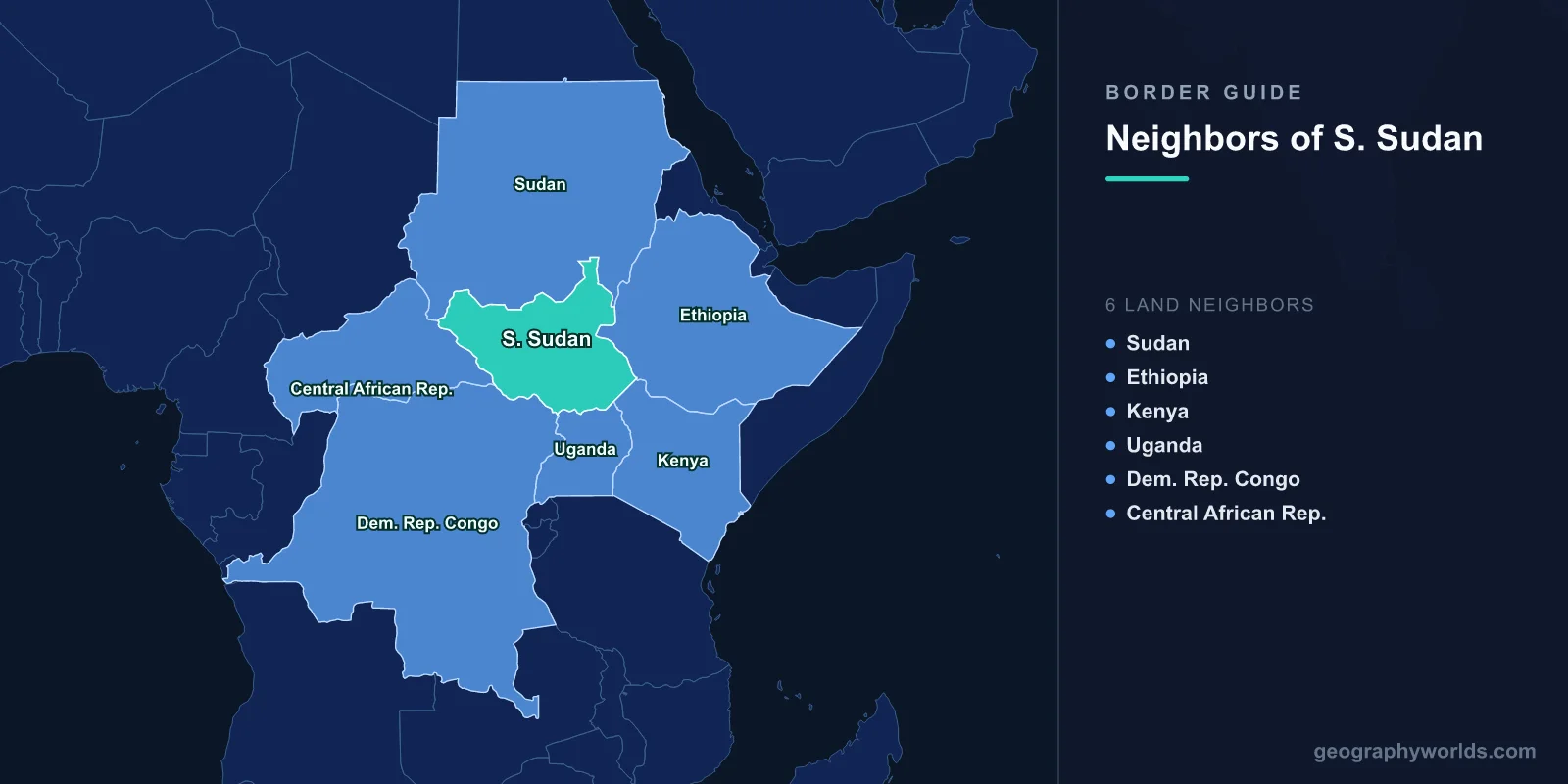
South Sudan shares land borders with six countries: Sudan to the north, Ethiopia to the east, Kenya and Uganda to the south-east and south, the Democratic Republic of the Congo to the south-west, and the Central African Republic to the west. It is landlocked, it became independent on 9 July 2011, and its boundary with Sudan is the most recent international frontier drawn in Africa. Substantial stretches of it have still not been agreed.
A Border Made From an Internal Line
The Sudan-South Sudan boundary was supposed to follow the administrative line between north and south as it stood on 1 January 1956, the date of Sudanese independence. That sounds precise and is not: the 1956 line was a colonial administrative convenience, recorded inconsistently, adjusted at various points, and never surveyed to the standard an international border requires.
The Comprehensive Peace Agreement of 2005 provided for a referendum on southern independence and for a technical committee to establish the line. The referendum was held in January 2011 and produced a vote of around 98 per cent for separation. The border committee did not finish its work, and it has not finished it since.
Five areas along the roughly 2,000-kilometre frontier remain contested, and the two states have repeatedly agreed and then failed to implement a demilitarised buffer zone along it. For long stretches there is no marked line at all, and communities on the ground rely on customary understandings about grazing and water.
Abyei
The sharpest dispute is Abyei, a fertile district on the boundary claimed by both. The Ngok Dinka, who are settled there and aligned with the south, live alongside the Misseriya, Arab cattle herders who migrate through seasonally from the north and whose route depends on access to its water.
The 2005 agreement provided for a separate referendum in Abyei on which country to join. It has never been held, because the two sides cannot agree who is entitled to vote — specifically whether the Misseriya, present for part of each year, should be included. An arbitration at The Hague in 2009 redrew Abyei's boundaries, reducing the area, and both parties accepted that ruling without it resolving the sovereignty question.
Sudanese forces seized Abyei in 2011, and a United Nations force, UNISFA, has been deployed there since. A community referendum organised unilaterally by the Ngok Dinka in 2013 voted overwhelmingly to join South Sudan and was recognised by nobody.
Oil on One Side, Pipeline on the Other
Independence divided Sudan's oil industry in the most awkward possible way. The great majority of the producing fields ended up in South Sudan; the pipelines, the refinery and the export terminal at Port Sudan on the Red Sea remained in Sudan.
Each state therefore held something the other could not do without, and the result was a standoff rather than a partnership. Disagreement over transit fees led Juba to shut down production entirely in January 2012, an act of self-harm that removed almost all government revenue from a country that had almost no other. Fighting broke out along the border at Heglig in April 2012 before an agreement resumed exports.
The dependence has not gone away. When the pipeline was damaged during Sudan's civil war in 2024, South Sudanese exports stopped for months and the government could not pay salaries. A landlocked producer whose only route to market crosses a neighbour at war has no good options.
Uganda, and the Road That Feeds Juba
The southern border with Uganda is South Sudan's commercial lifeline. Juba lies only a few hundred kilometres from the Ugandan frontier, and the road from Kampala through Nimule carries a very large share of the country's food, fuel and consumer goods.
Ugandan traders and Kenyan banks moved into Juba rapidly after 2005, and Uganda has been militarily involved too, deploying forces in 2013 in support of President Salva Kiir when the civil war began. That intervention was decisive in preventing the capital from falling and made Kampala a party to the conflict rather than a mediator.
The Nimule crossing is also where much of the country's displacement has passed. Hundreds of thousands of South Sudanese have taken refuge in northern Uganda, where the Bidi Bidi settlement became one of the largest refugee sites in the world.
Kenya, Ethiopia and the Ilemi Triangle
At the south-eastern corner lies the Ilemi Triangle, an area of roughly 10,000 to 14,000 square kilometres whose sovereignty has been ambiguous for a century. Colonial surveys produced several different lines, drawn to accommodate the grazing range of the Turkana, and none was ever settled definitively.
Kenya administers it in practice, South Sudan has not formally renounced a claim, and Ethiopia has historical interests nearby. The area is inhabited by pastoralists — Turkana, Toposa, Nyangatom, Dassanech — whose cattle raiding across the three-way frontier is the dominant security issue, and who are considerably better armed than they were.
The Ethiopian border further north runs through the Gambela region, where the Baro and Pibor rivers cross and where the Anuak and Nuer populations straddle the line. Cross-border raiding there has at points involved mass abductions of children, and Ethiopian forces have pursued into South Sudanese territory.
The Western Borders, and the Lord's Resistance Army
The frontiers with the Central African Republic and the Democratic Republic of the Congo run through remote forest and savanna in Western Equatoria and Western Bahr el Ghazal, and they are among the least governed borders anywhere.
They became internationally known because of the Lord's Resistance Army. Driven out of northern Uganda, Joseph Kony's forces moved into exactly this tri-border area, exploiting the absence of any state to operate between three jurisdictions. A regional task force with American advisers pursued them for years across borders that existed only on paper.
Cattle, and Borders That Herds Cross
Much of South Sudan's rural economy is pastoral, and the herding routes long predate the states. Misseriya cattle move south into Abyei and beyond each dry season; Toposa and Turkana herds cross the Kenyan line; Nuer and Anuak movements cross into Ethiopia.
Traditional arrangements governed these movements — negotiated access, compensation for damage, agreed watering points. The combination of automatic weapons, the commercialisation of cattle raiding and the collapse of the authorities who used to arbitrate has made these routes lethal. A raid that once cost a few animals now costs dozens of lives.
Where those arrangements have been revived, it has usually been through chiefs and churches rather than through governments, and the peace conferences that have worked best have been organised on customary rather than state lines.
Sudan's War Runs Back Across the Line
When war broke out between the Sudanese army and the Rapid Support Forces in April 2023, the flow across the northern border reversed. Hundreds of thousands of people crossed south, including large numbers of South Sudanese who had been living in Khartoum for years and were returning to a country many of their children had never seen.
They arrived at Renk, in Upper Nile, in numbers the transit facilities could not handle, in one of the poorest and least serviced parts of the country. A state that had been exporting refugees for a decade found itself receiving them.
The Sudd
Much of central South Sudan is occupied by the Sudd, one of the largest wetlands on earth, where the White Nile spreads across a vast floodplain of papyrus and reed. In the wet season it can cover an area comparable to England, and roughly half the river's flow is lost there to evaporation.
The Sudd is the reason the upper Nile was not navigated by outsiders until the nineteenth century, and the reason South Sudan's road network barely exists: building through seasonally flooded clay is ruinously expensive, and large parts of the country are reachable only by air or river for months at a time.
It is also the subject of one of Africa's longest-running engineering controversies. The Jonglei Canal, begun in 1978, was designed to bypass the Sudd and deliver additional water downstream to Sudan and Egypt. Excavation stopped in 1984 when the rebel movement attacked the works, with the machine roughly two-thirds of the way along, and the abandoned cut and the bucketwheel excavator are still there. Reviving it would be a decision about water taken far outside South Sudan's borders, and it is raised in Cairo and Khartoum considerably more often than in Juba.
Six Borders, No Coast, One Pipeline
South Sudan's fundamental position is that it holds oil and nothing else exportable at scale, and that every route to a customer crosses someone else's territory. The existing pipeline runs north through a country it fought a war with. The alternatives — east to Djibouti through Ethiopia, or south-east to Lamu in Kenya under the LAPSSET corridor plan — have been discussed for over a decade and not built.
That is the strategic meaning of six land borders and no sea. The country in wider terms is our South Sudan country guide; our Nile river guide follows the waterway crossing its northern border, and ten facts about South Sudan gathers the rest.
