
Bolivia is almost four times the size of Ecuador (about 1,098,581 km² against 283,561 km²), but Ecuador has more people: 16.9 million at its 2022 census, against Bolivia's 11.4 million in 2024. Ecuador has a Pacific coast, the Galápagos Islands, a single capital in Quito and the US dollar as its currency. Bolivia has been landlocked since the War of the Pacific (1879–84), splits its capital between Sucre and La Paz, pays in bolivianos, and recognises 36 indigenous languages alongside Spanish.
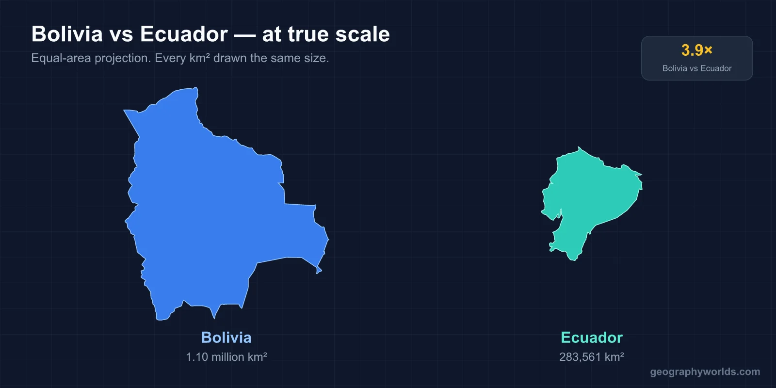
The two countries never touch. Peru lies between them, and the Andes tie all three together. The clearest way to compare Ecuador and Bolivia is to climb through them band by band, from sea level up to the high plateau and back down into the Amazon. Then come the capitals, the money and the people.
Sea Level: Ecuador's Pacific Coast and Bolivia's Lost Littoral
Ecuador's Costa is a lowland strip between the Pacific and the western foot of the Andes, around 2,200 km of coastline once the bays and estuaries are counted. Guayaquil, the country's largest city and main port, sits on the Guayas River estuary. The plantations and ponds around it make Ecuador the world's biggest exporter of bananas and one of the two largest exporters of farmed shrimp. About 1,000 km offshore lie the Galápagos, the reason Ecuador's area is sometimes given without them (276,841 km²). Ecuador's own mapping agencies also use a smaller national figure, about 256,370 km², so expect to see all three numbers quoted.
Bolivia once had a coast too. At independence in 1825 it held the Litoral province on the Atacama Desert, including the port of Antofagasta. A tax dispute with a Chilean nitrate company in 1878 led to the War of the Pacific. Chile defeated Bolivia and its ally Peru, and Bolivia lost roughly 400 km of shoreline and about 120,000 km² of land. The Treaty of Peace and Friendship of 1904 made the loss permanent. In return Chile built the Arica–La Paz railway and granted Bolivian cargo free transit through its ports.
Bolivia never accepted the result emotionally. It still keeps a navy, which patrols Lake Titicaca and the rivers, and every 23 March it marks the Día del Mar. In 2013 it took Chile to the International Court of Justice. On 1 October 2018 the court ruled 12 to 3 that Chile had no obligation to negotiate sovereign access to the sea. Bolivia is now one of only two landlocked countries in South America, along with Paraguay. The wider club is covered in our guide to landlocked countries.
The Andes: Avenue of the Volcanoes vs the Altiplano
In Ecuador the Andes run as two parallel ranges, the Cordillera Occidental and the Cordillera Real. Between them lies a chain of basins at 2,200–2,900 m, where Quito, Ambato, Riobamba and Cuenca sit. Alexander von Humboldt called it the Avenue of the Volcanoes. Chimborazo (6,263 m) is the highest peak, and because the Earth bulges at the equator its summit is the point on land farthest from the planet's centre. Cotopaxi (5,897 m), one of the world's highest active volcanoes, last erupted in 2015 and is watched closely by the Geophysical Institute in Quito.

Bolivia's Andes are wider and colder. The Cordillera Occidental on the Chilean border carries Nevado Sajama (6,542 m), the country's highest peak. The Cordillera Oriental, including the glaciated Cordillera Real above La Paz, forms the eastern wall. Between the two lies the Altiplano, a high plateau averaging about 3,750 m. It is one of the largest high plateaus on Earth outside Tibet. At its northern end Lake Titicaca, shared with Peru, sits at 3,812 m. Read more in our Lake Titicaca guide. At its southern end lies the Salar de Uyuni, a salt crust of roughly 10,500 km² that is the largest salt flat in the world.

The two highlands feel different. The Ecuadorian sierra is green, wet and volcanic, with tussock páramo above the farms. The Bolivian Altiplano is dry, treeless and open, with llamas, quinoa fields and wind.
Below the Mountains: Two Slices of the Amazon
East of the Andes both countries drop into the Amazon basin, but on very different scales. Ecuador's Oriente covers nearly half the national territory, yet it is home to only about 5% of the population. Yasuní National Park, on the Napo and Curaray rivers, is among the most biodiverse places measured anywhere. It also sits on oil: in an August 2023 referendum about 59% of Ecuadorians voted to stop drilling in Block 43 (the ITT field) inside the park.
Bolivia's lowlands are far larger. The llanos of Beni and Pando, the Chiquitano dry forest, the edge of the Pantanal and the Gran Chaco together cover around 60% of the country. They fall to about 90 m above sea level on the Paraguay River. Madidi National Park climbs from that rainforest to glaciers above 5,000 m in a single protected area. This half of Bolivia, centred on Santa Cruz de la Sierra, now has the largest city and most of the farm and gas economy. Many outsiders still picture the country as entirely highland.
Quito vs Sucre and La Paz: One Capital or Two
Ecuador keeps things simple. Quito, founded by the Spanish in 1534 on an Inca city, is the capital and the seat of every branch of government. Its historic centre and that of Kraków were the first two cities named World Heritage Sites, in 1978. It sits at about 2,850 m, just 25 km south of the equator.
Bolivia's constitution names Sucre as the capital, and the Supreme Court sits there. The president, the legislature and most ministries have been in La Paz since the Federal War of 1898–99, when La Paz's Liberals defeated Sucre's Conservatives. La Paz fills a canyon at about 3,640 m. Its twin city, El Alto, spreads across the Altiplano rim above it at around 4,150 m, and cable cars link the two. That makes La Paz the highest seat of government in the world. The ranking is explained in our list of the highest capital cities.
Oil and the Dollar vs Lithium, Gas and the Boliviano
Ecuador's modern economy began in 1972, when the Trans-Ecuadorian Pipeline started carrying Amazon crude over the Andes to the port of Esmeraldas. Oil is still the largest single export, ahead of shrimp, bananas, cocoa and cut flowers. In 1999 a banking collapse sent the old currency, the sucre, into free fall. In January 2000 President Jamil Mahuad announced that the US dollar would replace it at 25,000 sucres per dollar, and the switch was completed that September. Dollarisation has kept inflation low ever since. It also means Ecuador cannot print money or devalue in a crisis.
Bolivia went the other way. After hyperinflation in the mid-1980s it introduced the boliviano in 1987, and since 2011 it has held it at 6.96 to the dollar. Natural gas, nationalised on 1 May 2006 under Evo Morales, paid for a decade of growth through exports to Brazil and Argentina. Output has fallen since the mid-2010s. By 2023 the central bank was short of dollars, a parallel exchange rate had appeared, and fuel queues followed.
The hope is lithium. The US Geological Survey credits Bolivia with about 23 million tonnes of identified lithium resources, the largest of any country, most of it in brine beneath the Salar de Uyuni. Commercial output so far is tiny. The brine holds a lot of magnesium and the Altiplano is wet in summer, which complicates extraction. The 2023 contracts with Chinese and Russian firms have also been held up in the legislature. Bolivia also exports gold, zinc, silver and soy. Ecuador's GDP is roughly two and a half times Bolivia's, and its income per person is well ahead too.
Kichwa and Shuar vs 36 Official Indigenous Languages
Both countries call themselves plurinational, but the label means different things on the ground. Ecuador's 2008 constitution keeps Spanish as the official language. It gives Kichwa and Shuar status as "official languages of intercultural relations", and other indigenous languages are official in their own territories. About 8% of Ecuadorians identified as indigenous in the 2022 census. Most of the population is mestizo, with Afro-Ecuadorian communities in Esmeraldas and the Chota valley and Montubio farmers on the coast.
Bolivia went further. Its 2009 constitution, approved by referendum, renamed the country the Plurinational State of Bolivia. It made Spanish and 36 indigenous languages official, from Quechua, Aymara and Guaraní down to tongues spoken by a few hundred people in the Amazon. Public servants are meant to speak at least two of them. In the 2012 census about 41% of Bolivians identified with an indigenous people, the highest share in South America, and Morales (2006–2019) was the country's first indigenous president.
Peru, the Country Between Them
The fairest yardstick for both is Peru, the neighbour that separates them. Peru, at about 1,285,000 km² and roughly 34 million people, has Ecuador's full set of landscapes: a Pacific desert coast, Andean valleys and a huge Amazon. It also shares Bolivia's Altiplano and Lake Titicaca, and Aymara and Quechua communities live on both sides of that border.
History connects it to both, mostly through loss. Peru fought beside Bolivia in the War of the Pacific and gave up Tarapacá and Arica to Chile; it got Tacna back only in 1929. With Ecuador, Peru fought over the Amazon in 1941, 1981 and the Cenepa War of 1995. The 1942 Rio Protocol gave Peru most of the disputed jungle. The Brasília Presidential Act of 26 October 1998 finally closed the border. Until then, Ecuadorian school maps showed a slice of Amazon that Peru held. Bolivia's sense of a stolen coast is still very much alive.
Seen against Peru, the comparison comes out like this. Ecuador is a compact, crowded Andean country with a coast and a hard currency. Bolivia is a large, thinly settled one that lost its coast and is still deciding how to turn salt flats into an economy. For the other half of the triangle, see our comparison of Ecuador and Peru, where the old border war takes centre stage.