
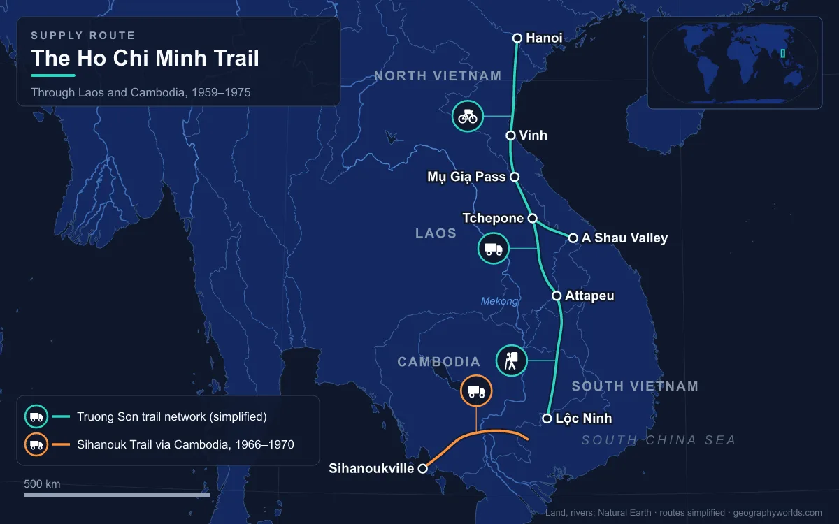
From May 1959 to the fall of Saigon on 30 April 1975, the Ho Chi Minh Trail was North Vietnam’s overland supply network to the south, a web of footpaths, truck roads, river routes and fuel pipelines that ran from North Vietnam through the Annamite Range of eastern Laos and north-eastern Cambodia into South Vietnam. Known to the North Vietnamese as the Trường Sơn Strategic Supply Route, after the Vietnamese name for the Annamite mountains, it grew from a porters’ track into a system with thousands of kilometres of roads, a corridor up to 140 km wide and a fuel pipeline that reached Lộc Ninh, north of Saigon. It mattered because it kept the People’s Army of Vietnam (PAVN) and the Viet Cong supplied with men, weapons and fuel despite the most intense air interdiction campaign in history; between 1965 and 1973 the United States dropped about 2.76 million tons of ordnance on Laos.
Group 559 and the Porters’ Paths, May 1959–1964
Parts of the route were centuries old: trading footpaths through mountains 500–2,400 m high, covered in multi-layered tropical forest. The Viet Minh had used them against the French in the First Indochina War. In May 1959, months after the ruling party in Hanoi approved a “people’s war” in the South that January, Hanoi created Group 559, a logistics unit charged with opening routes to the south through Laos. Its headquarters were at Na Kai in Houaphan province, just inside Laos, under Colonel Võ Bẩm; some histories date the group’s formal establishment to September 1959 instead. A maritime counterpart, Group 759, ran supplies by sea in about 20 steel-hulled boats.
The trail could only develop because North Vietnam controlled the Lao side. PAVN and Pathet Lao forces had seized the road hub of Tchepone on Laotian Route 9 in May 1958, and on 28 July 1959 they attacked along the border against the Royal Lao Army. At first the route moved people rather than cargo: about 500 of the southerners who had regrouped to the North after the 1954 Geneva Accords were sent back down the trail in its first year, a mountain trek of about six months, and the first arms delivery was completed in August 1959.
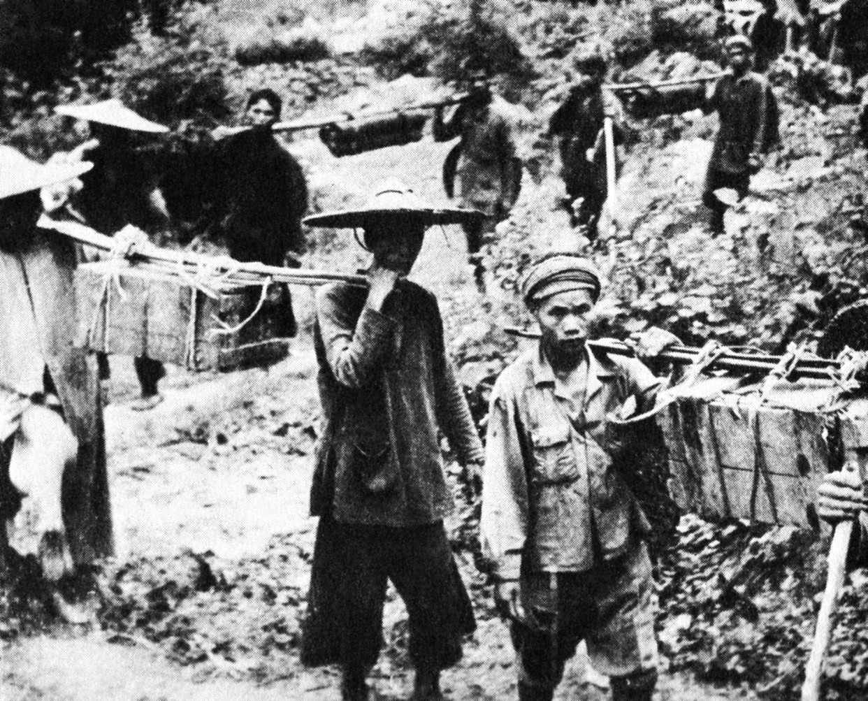
By the end of 1959 Group 559 had about 6,000 personnel in its 70th and 71st regiments alone, plus local labourers. Loads went on porters’ backs, on oxcarts and on heavily laden bicycles pushed by hand. In December 1961 the 3rd Truck Transportation Group became the first motor unit on the trail. Infiltration figures rose slowly, about 4,000 people in 1961, 5,300 in 1962 and 9,000 in 1964, and by 1964 the trail could move 20–30 tonnes of supplies a day.
Steel Tiger, B-52s and the Mụ Giạ Pass, 1965–1967
Systematic bombing began on 14 December 1964 under Operation Barrel Roll. In April 1965 the area was split: Barrel Roll continued over north-eastern Laos and Operation Steel Tiger covered the southern panhandle, where the trail ran; Tiger Hound later took the strip next to South Vietnam’s northern provinces. The first B-52 strike in Laos came on 10 December 1965, and that month Ranch Hand aircraft began spraying defoliants, eventually about 1.8 million litres over more than 210 missions. By the end of 1967, 103,148 tactical air sorties had been flown in Laos, supplemented by 1,718 B-52 strikes, and 132 US aircraft or helicopters had been shot down over the country.
The trail grew anyway. In April 1965 General Phan Trọng Tuệ took command of 24,000 men in six truck battalions, two bicycle battalions, a boat battalion and eight engineer battalions. Trucks of Soviet, Chinese and other Eastern Bloc make, by now the chief means of transport, entered Laos mainly through the Mụ Giạ Pass, 418 m high, about 90 km north-west of Đồng Hới. The network was organised into Binh Trams, regimental-sized logistics commands each responsible for one stretch, with way-stations roughly a day’s march apart. Monsoon rain, about 3,800 mm a year with 70% falling between mid-May and mid-September, concentrated heavy traffic in the dry season from mid-October to mid-March. Between 58,000 and 90,000 troops went south in 1966, and in 1967 Senior Colonel Đồng Sỹ Nguyên took over Group 559. By the end of that year it had 2,959 km of roads usable by vehicles.
A second route opened in Cambodia. After Prince Norodom Sihanouk broke with Washington in April 1965, communist ships unloaded arms at the port of Sihanoukville, and between 1966 and 1970 trucks carried them east to the border along what the US called the Sihanouk Trail. It later transpired that this Cambodian route had handled significantly more material than the Laotian network.
Commando Hunt and Igloo White, November 1968–March 1972
Before the Tet Offensive of early 1968 the North moved more than 81,000 tonnes of supplies and about 200,000 troops south. When Operation Rolling Thunder, the bombing of North Vietnam, ended on 2 November 1968, US aircraft were switched to Laos. Operation Commando Hunt began on 15 November 1968, sorties over southern Laos tripled from 4,700 in October to 12,800 in November, and in 1969 about 433,000 tonnes of ordnance fell on Laos. Operation Igloo White scattered acoustic and seismic sensors along the roads, and computers at Nakhon Phanom in Thailand used their signals to predict convoy routes and direct strikes. Experiments added to the effort: Project Popeye flew cloud-seeding missions in every rainy season from March 1967 to 1972 to lengthen the monsoon over the trail.
Trucks responded by moving at night in relays, unloading at each station and reloading onto fresh vehicles. By the last phase, from October 1970 to April 1972, an average day brought 182 attack fighters, 13 gunships and 21 B-52s over the corridor, and more than 1,500 anti-aircraft guns defended it. North Vietnam’s official history named the AC-130 Spectre gunship as its most dangerous opponent and recorded about 4,000 trucks destroyed in the 1970–71 dry season. On 29 March 1972 an SA-7 missile brought down a Spectre near Tchepone, and Commando Hunt ended the same day.
The Vinh Pipeline and the Truong Son Army, 1968–1971
Late in 1968 US analysts found a fuel pipeline running south-west from the port of Vinh. Built by Road Work Team 18 under Lieutenant Colonel Phan Tu Quang and Major Mai Trong Phuoc, it crossed into Laos through the Mụ Giạ Pass early in 1969 and reached the approaches to the A Shau Valley in 1970. The plastic pipe carried diesel, petrol and kerosene through the same line, pushed by small pumping stations; with the 592nd Pipelaying Regiment, six lines were entering Laos that year. Its builders laid about 5,000 km of pipeline and moved more than 270,000 tonnes of fuel.
In 1970 Group 559 became the Truong Son Army, with the status of a military region. That year its 27 Binh Trams moved about 40,000 tonnes of supplies with a reported loss rate of 3.4%. PAVN forces also took Attapeu and Salavan at the foot of the Bolaven Plateau, opening the Kong River into Cambodia, and the 470th Transportation Group ran a new branch from Muong May to the Mekong at Stung Treng. Once US Special Forces camps at Khe Sanh, Kham Duc and Dak Seang had been abandoned or overrun, a corridor that had been about 30 km wide spread to about 140 km from east to west.
Lam Son 719 at Tchepone, February–March 1971
The long-sought ground assault on the trail itself came in February 1971, when 16,000 and later 20,000 South Vietnamese troops advanced along Route 9 towards Tchepone. US ground forces were barred by law from entering Laos, so the United States supplied air support, artillery and helicopters. PAVN massed about 60,000 troops, with tanks and heavy artillery, and dense anti-aircraft fire shot down 108 helicopters and damaged 618. South Vietnamese troops reached Tchepone by air assault but could not hold it, and the last units recrossed the border on 25 March 1971, having lost about half the invasion force. The operation is credited with delaying a planned offensive in the northern provinces by a year.
Paved Roads to Lộc Ninh and the Road to Saigon, 1972–1975
The Easter Offensive began on 30 March 1972, when 30,000 PAVN troops with more than 300 tanks crossed into Quảng Trị Province. Ground taken inside South Vietnam let the trail run on Vietnamese territory, and after the Paris Peace Accords the last US forces left in March 1973. That year the system included a two-lane road surfaced with crushed limestone and gravel from the northern passes to the Chu Pong Massif; by 1974 a four-lane paved route ran from the Central Highlands to Tây Ninh Province, north-west of Saigon. The pipeline now ran in four lines, the largest 20 cm wide, all the way to Lộc Ninh. In July 1973 the force was renamed the Truong Son Command, and by late 1974 it fielded engineering, transport, anti-aircraft and infantry divisions under Major General Hoàng Thế Thiện. That logistic base supported General Văn Tiến Dũng’s Campaign 275 in March 1975 and the final offensive that took Saigon on 30 April 1975.

The cost to the region outlived the war. Between 1965 and 1973 the US dropped 2,756,941 tons of ordnance on 113,716 sites in Laos in 230,516 sorties, a figure that covers the whole country, with Xiangkhouang province around the Plain of Jars the hardest hit, not only the trail. About 30% of bombs failed to explode, leaving an estimated 78 million pieces of unexploded ordnance; Lao government figures put post-war casualties from it at about 20,000. Today the Ho Chi Minh Highway follows the old route inside Vietnam, splitting into eastern and western branches in Quảng Bình province. The landscapes the trail crossed are described in our guide to the geography of Laos, and the three-way frontier it exploited appears in our page on the countries that border Vietnam.