

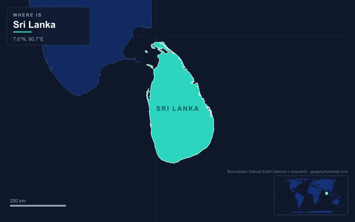
Sri Lanka is in Asia, not Africa: it is an island country in South Asia, lying in the Indian Ocean just off the southeastern tip of India, from which it is separated by the shallow Palk Strait and Gulf of Mannar. At the narrowest point, where the chain of shoals called Adam’s Bridge runs between the two, the gap to India is only about 30 km, while the nearest point of mainland Africa, in Somalia, is more than 3,000 km away across open ocean. Sri Lanka sits on the Indian Plate with India, the United Nations counts it in Southern Asia, and it was one of the seven founding members of the South Asian Association for Regional Cooperation (SAARC) in 1985. The confusion with Africa has a real basis, though, and it lies hundreds of millions of years in the past.
Gondwana and the Indian Plate: the African connection that ended 140 million years ago
The one sense in which Sri Lanka was once joined to Africa is geological. More than 90% of the island’s surface rests on Precambrian rock, some of it about 2 billion years old. These rocks, like those of most of southern India, formed part of Gondwana, the great southern supercontinent that also contained Africa, Antarctica, Australia and South America. Until roughly 140 million years ago the land that is now Sri Lanka and India was part of that single mass.
Gondwana then broke apart. India, still attached to Madagascar, split away from the rest, and around 100 million years ago the Indian Plate separated from Madagascar and began moving north at about 20 cm a year. If the earlier collision date is right, that would make it faster than any other plate known. The plate carried India and Sri Lanka with it, opened the Indian Ocean behind them and began colliding with Asia perhaps as early as 55 million years ago, an impact that is still raising the Himalayas. Some researchers place the collision later, around 35 million years ago.
The result is that Sri Lanka today rides near the middle of the Indian Plate, the same plate that carries most of South Asia. That position explains a quieter fact about the island: because it is far from the plate’s edges, Sri Lanka does not experience major earthquakes or volcanic eruptions, although its coast was badly hit by the 2004 Indian Ocean tsunami, when its 7,000 hectares of mangroves helped buffer the waves. The rocks even record the long link with India. The sediments along the northwest coast belong to the deep Cauvery Basin of southeast India, which has been collecting material from the highlands of both India and Sri Lanka since Gondwana broke up.
So the African connection is real, but it belongs to deep time: India and Madagascar parted about 100 million years ago, and every geographical, political and statistical classification in use today places Sri Lanka in Asia.
65,610 km² between 5° and 10° N: the island’s position and extent
Sri Lanka lies between latitudes 5° and 10° N and longitudes 79° and 82° E, southwest of the Bay of Bengal. The country covers 65,610 km² in all, of which 64,630 km² is land. The main island alone measures 64,058 km², which makes it about the 25th-largest island in the world and similar in size to Tasmania, and dozens of small offshore islands make up the rest. Several of the larger ones, including Mannar Island, lie off the north coast, facing India.
Inland, the island is mostly flat to rolling coastal plain, with mountains only in the south-central interior. The highest point is Pidurutalagala, 2,524 m, north-northeast of the hill town of Nuwara Eliya. Sri Lanka has 103 rivers; the longest, the Mahaweli, runs 335 km, and the island has 51 natural waterfalls of 10 m or more, the highest being Bambarakanda Falls at 263 m. The climate is shaped by two Asian monsoons, the northeast monsoon from December to March and the southwest monsoon from June to October.
The southernmost point is Dondra Head near Matara, about 660 km north of the equator (computed from coordinates). Its lighthouse marks the last land before the open Indian Ocean, which stretches south to Antarctica.

Measured from the commercial capital, the distances settle the continental question on their own. As great-circle distances computed from coordinates, Colombo is about 690 km from Chennai in India and about 770 km from Malé in the Maldives, but about 3,150 km from Ras Hafun in Somalia, the easternmost point of mainland Africa, and about 3,870 km from Mogadishu. Africa’s island states are nearer but still distant: Mahé in the Seychelles is about 3,000 km from Colombo, and the Chagos Archipelago, which Britain agreed in a treaty signed on 22 May 2025 to transfer to Mauritius, lies roughly 1,800 km to the south-west.
The people reflect the island’s South Asian setting too. The 2024 census counted 21,781,800 people. Sinhalese, who speak Sinhala, made up 74.12%; Sri Lankan Tamils 12.31%; Sri Lankan Moors 10.47%; and Indian Tamils (Malayaga Thamilar) 2.76%. Smaller groups include Burghers of European descent, Malays and the indigenous Veddas.
Palk Strait and Adam’s Bridge: a 48 km chain of shoals between Sri Lanka and India
Sri Lanka’s nearest neighbour is India, and in places the two almost touch. The Palk Strait runs between Pamban Island in the Indian state of Tamil Nadu and Mannar Island in Sri Lanka’s Northern Province. It is about 137 km long and 64 to 137 km wide, links the Bay of Bengal to the Laccadive Sea, and is named after Robert Palk, governor of Madras from 1755 to 1763. Its waters reach a maximum depth of only 35 m, and the shallows, small islands and reefs make it difficult for large ships to pass, although fishing boats and small craft navigate it.
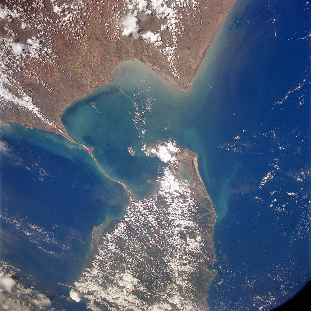
At the southern end of the strait lies Adam’s Bridge, also called Rama Setu: a 48 km chain of limestone shoals that separates the Gulf of Mannar to the southwest from the Palk Strait to the northeast. It starts at Dhanushkodi on India’s Pamban Island and ends at Sri Lanka’s Mannar Island; in a straight line the gap between Dhanushkodi and Talaimannar is about 32 km (computed from coordinates). Some sections are dry, and the sea over most of it is rarely more than 1 m deep.
During the last glacial period, when sea levels were as much as 120 m lower than today, the entire Palk Strait was dry land and Sri Lanka was physically part of the Asian mainland. Rising seas submerged the link by about 7,000 years ago. At the Indian end of the chain, some records of the Ramanathaswamy Temple at Rameswaram suggest that violent storms broke a land link across the Pamban channel in 1480. The bridge carries layers of meaning: in popular Hindu belief it is the bridge built by Rama in the Ramayana, while the name Adam’s Bridge, recorded from around the time of Al-Biruni (c. 1030), comes from the Islamic tradition that Adam crossed here from Adam’s Peak in Sri Lanka.
Today both ends are linked to their mainlands, India’s by the 2 km Pamban Bridge and Sri Lanka’s by a causeway to Mannar Island, and the railway to Talaimannar pier was reopened in 2015 after being wrecked during the civil war. Out to sea, Sri Lanka shares maritime boundaries with India to the northwest and the Maldives to the southwest, and faces Bangladesh, Myanmar and India’s Andaman and Nicobar Islands across the Bay of Bengal. No African country is among its maritime neighbours.
Southern Asia for the UN, a SAARC founder in Dhaka in 1985
Every international grouping that sorts countries by region puts Sri Lanka in Asia. The United Nations geoscheme places it in Southern Asia, a subregion that combines the Indian subcontinent with Afghanistan and Iran. In 1985 Sri Lanka was one of the seven countries, with Bangladesh, Bhutan, India, the Maldives, Nepal and Pakistan, that founded SAARC in Dhaka on 8 December; Afghanistan later became the eighth member, and the secretariat is in Kathmandu. Together the SAARC members held about 21% of the world’s population in 2021, although the group has not held a summit since the 18th, in Nepal in November 2014, after the 2016 summit planned for Pakistan was postponed indefinitely. Colombo had already hosted the Colombo Powers Conference of April 1954, one of the early meetings on South Asian cooperation, and the first meeting of the seven foreign ministries’ officials in April 1981.
Sri Lanka is also a founder of BIMSTEC, the Bay of Bengal grouping launched in Bangkok on 6 June 1997 as BIST-EC by Bangladesh, India, Sri Lanka and Thailand; Myanmar joined that December, and Nepal and Bhutan followed, giving it seven members today. Its history ties it to the subcontinent as well: the Pali Canon, the earliest Buddhist writings on the island, dates to 29 BCE, its coasts were controlled in turn by the Portuguese and the Dutch, and the British ruled the island as a colony from the early 19th century until it gained independence as the Dominion of Ceylon in 1948. It kept the name Ceylon until it became a republic in 1972.
To see how the island compares with its Indian Ocean neighbour to the southwest, read Sri Lanka vs the Maldives; for a fuller look at its mountains, rivers and coast, see Sri Lanka’s geography, or start from the map in where Sri Lanka is.