

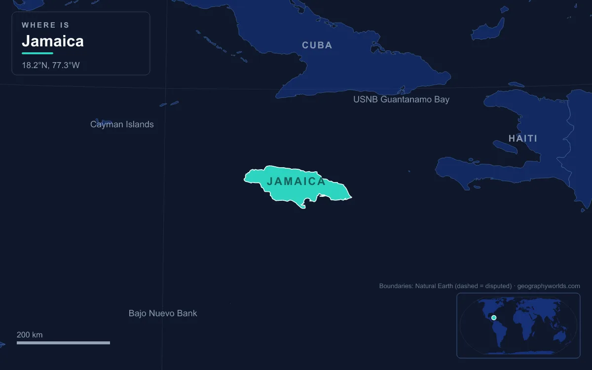
From the summit of Blue Mountain Peak, 2,256 m above the Caribbean, clear mornings reveal the outline of Cuba, which lies 140 km north of the island. Jamaica, the island below, is the third-largest of the Greater Antilles after Cuba and Hispaniola: about 10,990 km², 235 km long and between 34 and 84 km wide, lying 190 km west of Haiti. It divides into three landform regions: the eastern mountains, led by the Blue Mountains and the John Crow Mountains; the central valleys and limestone plateaus, which cover about two-thirds of the island and include the karst of the Cockpit Country and the Manchester Plateau; and the coastal plains, widest in the south. The highest point is Blue Mountain Peak and the lowest is sea level. The longest river is the Rio Minho, 92.8 km, followed by the Black River, 53.4 km, and the island averages about 1,960 mm of rain a year. Its roughly 2.8 million people live mostly on the plains and in Kingston. The clearest way to understand the island is to start at the top and walk down.
Blue Mountain Peak and the Blue Mountains Ridge
Blue Mountain Peak stands on the boundary between the parishes of Portland and Saint Thomas, and it is the tallest summit in the Caribbean outside Hispaniola. It sits on a central ridge of old metamorphic rock that runs northwest to southeast, with long spurs dropping away to the north and south. For more than 3 km the crest stays above 1,800 m, yet the range climbs to that height from the coastal plain in only about 16 km, one of the steepest general gradients in the world. This is one of the few places where the island's ancient foundations show: Jamaica and the other Antilles grew from an arc of volcanoes, and over most of the island that igneous and metamorphic rock lies buried under limestone thousands of feet thick. Here it breaks through.
The usual route to the summit is an 11 km trail climbing about 910 m, normally walked in darkness so that hikers reach the top at sunrise. Near the top, temperatures can dip below 10 °C, while the lowlands average 23.5 to 30 °C. The cold stunts the vegetation, and some of the dwarfed plants on the peak grow nowhere else. Lower down, the small farming communities of Hagley Gap and Claverty Cottage grow Blue Mountain coffee on the slopes.
The Blue and John Crow Mountains National Park
The high ground is protected in the Blue and John Crow Mountains National Park, 495.2 km², or 4.5 percent of Jamaica's land. UNESCO inscribed it as a mixed natural and cultural World Heritage Site on 3 July 2015. It is one of only two known homes of the Homerus swallowtail, the largest butterfly in the Western Hemisphere, and its cloud forests shelter the Jamaican blackbird, the Jamaican boa and the Jamaican coney, a hutia that is the island's only native land mammal. The "John Crow" in the name is the local word for the turkey vulture.
These mountains also make Jamaica's weather. Warm trade winds from the east and northeast rise over them, and on the high, windward slopes rainfall exceeds 5,080 mm a year. The southwestern half of the island lies in their rain shadow and gets less than 760 mm, a semi-arid climate within a day's drive of one of the wettest places in the Caribbean.
Down Onto the Limestone: the John Crow Mountains, Cockpit Country and Manchester Plateau
North of the Blue Mountains, the John Crow Mountains are a different kind of upland: a strongly tilted limestone plateau rising above 1,000 m. From here westward, limestone dominates, and so does karst, the landscape rainwater carves by dissolving rock. Sinkholes, caves, disappearing streams, hummocky hills and red terra rossa soils in the hollows are all found on the island.
The Cockpit Country
The most extreme karst is the Cockpit Country, which spreads mainly across Trelawny and Saint Elizabeth and into Saint James, Saint Ann, Manchester and the northern tip of Clarendon. It is a maze of steep-sided hollows, the "cockpits", separated by cone-shaped hills and ridges under montane forest. Its northern edge is a fault-line escarpment running from Flagstaff through Windsor to Campbells. The Barbecue Bottom Road, cut along the side of a deep fault valley in the east, is the only drivable route across it; farther west the old Troy and Quick Step trails are barely used.
That roughness made the Cockpit Country a refuge. In the late 17th century people escaping slavery on the plantations of the lowlands settled here as Maroons, and during the First Maroon War the Leeward Maroon communities of Cudjoe's Town and Accompong held out in these hills until they made peace with the colonial authorities. The district near Quick Step is still called the Land of Look Behind, after the story that Spanish horsemen rode two to a horse there, one facing backwards to watch for ambush.
The central plateaus and their red soils
Farther east, the centre of the island holds two high, rolling plateaus: the Dry Harbour Mountains to the north and the Manchester Plateau to the south. Streams that rise on the older rocks between them flow outward and vanish soon after reaching the limestone. Mandeville, at 628 m on the Manchester Plateau and 103 km west of Kingston, is the only parish capital in Jamaica not on the coast or a major river.
The plateau soils hold Jamaica's most valuable mineral, bauxite. After it was found in the 1940s, companies such as Alcan moved into Manchester, opening the Kirkvine works at Williamsfield, near Mandeville, in 1957; deposits are also worked in Saint Ann, Saint Elizabeth, Clarendon and Trelawny. By the late 1960s Jamaica produced about 21 percent of the world's bauxite. Where the ridges between sinkholes have dissolved completely, flat-floored basins of terra rossa have formed, among the most productive farmland on the island. The largest, the Vale of Clarendon, is 80 km long and 32 km wide; Queen of Spains Valley, Nassau Valley and Cave Valley formed the same way.
Rivers Off the Plateau: the Rio Minho, Black River and Dunn's River Falls
Because so much water sinks into the limestone, Jamaica's rivers often start as springs where it re-emerges. The Rio Minho, the island's longest river at 92.8 km, rises close to Jamaica's geographic centre and flows south-southwest past May Pen to reach the sea at Carlisle Bay, west of Portland Point, the island's southernmost tip. For decades the Black River was thought to be longer; at 53.4 km it is the second. In 2022 the International Union of Geological Sciences listed the rocks along the Rio Minho among its first 100 geological heritage sites for their thick limestone packed with fossil rudist clams from the Late Cretaceous.
The Black River begins in the Cockpit Country itself, running underground before it surfaces north of Siloah and winds through the cane fields of the Appleton Estate. Its name comes from its dark bed, lined with decaying vegetation. In its lower course it crosses the Upper and Lower Morass, where 17,769 hectares are designated an Important Bird Area by BirdLife International; more than 100 bird species have been recorded there.

On the wetter northern and eastern sides, rivers are shorter and steeper. The Rio Grande, named "Big River" by the Spanish, drains the Blue Mountains through Portland and is now used mainly for rafting. Near Ocho Rios, Dunn's River Falls drops about 55 m over a run of some 180 m over natural terraces of travertine, rebuilt constantly by calcium-rich spring water, with pools between the steps, and empties straight onto a white-sand beach.

Sea Level: Kingston Harbour, the Palisadoes and Jamaica's Four Coasts
At the bottom of the descent, the coasts differ sharply. The northeast shore is battered by the ocean, full of small inlets and with no coastal plain to speak of. Along the north, a narrow plain of uplifted coral reef backs calm water and white-sand beaches. The south has short stretches of black-sand beach backed by limestone cliffs where the plateaus end; where there is no plain at all, the cliffs drop 300 m straight into the sea. In the southwest broad plains run inland for several kilometres, much of them filled by the Great Morass and the Upper Morass, and the west has the island's best beaches. The four extreme points are Half Moon Point in Saint James, Portland Point in Clarendon, South Negril Point in Westmoreland and Morant Point in Saint Thomas.
Kingston owes its site to the sea. The Liguanea Plains, flat lands of fertile alluvium, spread south to Kingston Harbour, the seventh-largest natural harbour in the world: about 16 km long and 3.2 km wide, almost enclosed, and deep enough for large ships close to shore. It is sheltered by the Palisadoes, a thin sand tombolo carrying Norman Manley International Airport and the old town of Port Royal. On 7 June 1692 an earthquake sank most of Port Royal below sea level; about 2,000 people died in the quake and tsunami and some 3,000 more in the days after. The shaking has a cause: the Enriquillo–Plantain Garden fault zone runs through Jamaica, part of the boundary between the Caribbean plate and the Gonâve microplate.
The sea also brings Jamaica's greatest hazard. The island lies in the main development region for Atlantic hurricanes, and Hurricane Gilbert in 1988 hit it directly. In late October 2025 Hurricane Melissa, whose peak sustained winds of about 305 km/h tied the record for an Atlantic hurricane, made landfall at New Hope in Westmoreland, far surpassing any earlier landfall on the island. Offshore, Jamaica's territory continues across Pedro Bank, a shallow platform with cays running more than 160 km southwest of the island, and the Morant Cays, 51 km from Morant Point, within an exclusive economic zone of 258,137 km².
To see how Jamaica compares with its neighbours, read whether Jamaica is bigger than Puerto Rico, explore the wider Caribbean Sea, or turn from landforms to people and history in the Jamaica country guide.