
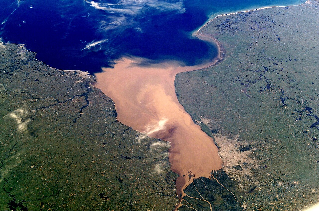
The Río de la Plata Basin is the second-largest river basin in South America after the Amazon, covering about 3.1 million km² — roughly 17% of the continent — across five countries: Brazil (which contains the largest share), Argentina, Paraguay, Bolivia, and Uruguay. The basin is named after the Río de la Plata estuary at its mouth, where the Paraná and Uruguay rivers combine before discharging into the South Atlantic between Buenos Aires and Montevideo. The Paraná is the basin's main river, the second-longest in South America at about 4,880 km, and combined with the Paraguay (2,621 km) and Uruguay (1,838 km) it forms one of the world's most distinctive river systems. The basin produces about 70% of the GDP of all five member countries, hosts the Iguazu and Itaipú on the Paraná, and supports more than 100 million people.
Introduction
The La Plata system is the South American counterpart to the Mississippi or the Volga — a continental river basin that organises the agricultural, urban, and industrial geography of an entire region. It is anchored at its mouth by the Buenos Aires-Montevideo metropolitan area, contains the spectacular Iguazu Falls (the largest waterfall system in the world by combined width), and hosts Itaipú — once the largest hydroelectric facility in the world. The basin's position connecting tropical Brazil to temperate Argentina makes it one of the most agriculturally productive regions on Earth, particularly for soybeans, corn, beef, and wheat.
Geography & Extent
The La Plata system has three main components. The Paraná rises on the Brazilian Plateau (formed by the confluence of the Paranaíba and Grande in Minas Gerais) and flows generally south and southwest, forming much of the Brazil-Paraguay and Argentina-Paraguay borders, before reaching its mouth at the Río de la Plata. The Paraguay rises in Mato Grosso, Brazil, flows south through the vast Pantanal wetland (the world's largest tropical wetland), and joins the Paraná at the Argentine-Paraguayan border. The Uruguay rises in southern Brazil and forms most of the Brazil-Argentina and Argentina-Uruguay borders before joining the Paraná in the Río de la Plata estuary. The Río de la Plata itself is technically a great funnel-shaped estuary — at its widest, it is over 220 km across, the widest river estuary in the world. Major tributaries include the Iguazú (containing Iguazu Falls), Tietê, Pilcomayo, Bermejo, and Salado.
Hydrology
The combined La Plata system has an average discharge of about 22,000 m³/s at its mouth, ranking it fifth in the world by volume after the Amazon, Congo, Orinoco, and Yangtze. The Paraná alone carries about 17,300 m³/s; the Uruguay adds about 4,500 m³/s; the Paraguay adds about 4,300 m³/s (with most of the Pantanal flow lost to evaporation in the wetland). Discharge is moderately seasonal, with peaks in February-March from austral summer rains. Major dam projects on the Paraná — Itaipú (binational with Paraguay), Yacyretá (binational with Argentina), and dozens of upstream Brazilian dams — store substantial fractions of average annual flow and have substantially altered the basin's hydrology. Sediment loads are large in absolute terms (about 100 million tonnes per year reach the estuary), but per-area sediment delivery is moderate compared to Asian rivers.
Geology & Formation
The La Plata Basin sits on the South American craton (the stable continental interior), with extensive Mesozoic flood basalts of the Paraná Volcanic Province (related to the breakup of Gondwana around 130 million years ago) underlying much of the upper basin. The Paraná Plateau exposes some of the largest Mesozoic basalt sequences in the world, and the Iguazu Falls are formed where the Iguazú River plunges over the southern edge of these basalts. The lower Paraná flows across a broad sedimentary plain (the Pampas) underlain by Cenozoic sediments and Quaternary loess. The Pantanal is a Quaternary tectonic depression with about 4,500 m of sedimentary fill, drained inadequately to the Paraguay.
Climate & Ecology
The basin spans humid subtropical in southern Brazil and the Argentine Mesopotamia, semi-arid in the western Chaco and northern Argentine Pampas, and humid temperate in the lower estuary region. Rainfall ranges from over 2,000 mm in southeastern Brazil to under 500 mm in the western Chaco and Pilcomayo headwaters. Major ecosystems include the Pantanal (the largest tropical wetland in the world, hosting jaguars, caimans, capybaras, hyacinth macaws, and the largest concentration of waterfowl in South America), the Atlantic Forest of southern Brazil and northern Argentina (one of the world's most threatened biodiversity hotspots, with less than 10% of its original extent), the Gran Chaco (the second-largest forest in South America after the Amazon), and the Pampas grasslands. The Iguazu Falls anchors the Atlantic Forest National Park (Brazil) and Iguazú National Park (Argentina) — both UNESCO World Heritage Sites.
Cultural & Historical Significance
The La Plata Basin has been the heartland of South American civilisations for thousands of years — the Guaraní, Tupi, Charrúa, Kaingang, Mbyá, and many others built complex pre-Columbian societies along its rivers. Spanish and Portuguese colonial expansion mapped the basin in the 16th-17th centuries; the Jesuit missions of Paraguay and northern Argentina (1607-1768) created a remarkable network of indigenous-cooperative communities along the upper Paraná and Uruguay. Buenos Aires (founded 1536, refounded 1580) and Montevideo (founded 1726) anchor the basin's mouth and grew into major Atlantic ports. The 19th-century Triple Alliance War (1864-70), one of the deadliest wars in modern Latin American history, was fought across the upper basin. Today the basin is the agricultural and economic centre of all five member countries, with São Paulo (just outside the basin but tied to it via the Tietê) and Buenos Aires anchoring the region's two largest urban concentrations.
Modern Issues
Three issues dominate modern La Plata governance. First, hydropower and navigation: the Paraná has been intensively dammed (Brazil has built more than 50 major dams on the basin's upper tributaries), and there are continuing proposals for major navigation works on the Paraguay-Paraná Hidrovía. Second, deforestation: the Atlantic Forest is over 90% lost, the Cerrado (in the upper basin) is rapidly being converted to soy and cattle, and even the Chaco is losing forest faster than the Amazon in percentage terms. Third, climate change: the Paraná saw its lowest flows in 80 years during the 2019-22 drought, with major effects on Itaipú generation and downstream navigation. Pantanal megafires in 2020 burned roughly 30% of the wetland and were driven by record drought and land-clearing fires. The Paraná-Paraguay basin is also the source of about 20% of the world's soybean exports, making basin land-use change globally significant for food markets and climate.
Frequently Asked Questions
How big is the La Plata Basin?
About 3.1 million km² across five countries (Brazil, Argentina, Paraguay, Bolivia, Uruguay) — the second-largest river basin in South America after the Amazon and the fifth-largest in the world.
What are the main rivers in the La Plata system?
The Paraná (the longest, 4,880 km), the Paraguay (2,621 km, mostly in Brazil and Paraguay), and the Uruguay (1,838 km, between Brazil, Argentina, and Uruguay). They combine to form the Río de la Plata estuary.
What is the Itaipú Dam?
Itaipú is a binational hydropower facility on the Paraná River between Brazil and Paraguay, completed in stages from 1984 onward. With 14 GW of installed capacity, it was the largest hydroelectric plant in the world by installed capacity until being surpassed by the Three Gorges, but it remains the world leader by annual energy generation in most years.
What is the Río de la Plata?
The Río de la Plata is the great funnel-shaped estuary at the mouth of the Paraná and Uruguay rivers, about 290 km long and up to 220 km wide. It separates Buenos Aires (Argentina) from Montevideo (Uruguay) and is the widest river estuary in the world.
Final Thoughts
The La Plata Basin is one of the most economically important and ecologically diverse river systems on Earth — anchoring South American agriculture, hydropower, and urban geography while containing some of the world's most threatened tropical and subtropical ecosystems. Its future is closely linked to the global soybean economy and to the continent's response to climate-driven hydrological extremes.