
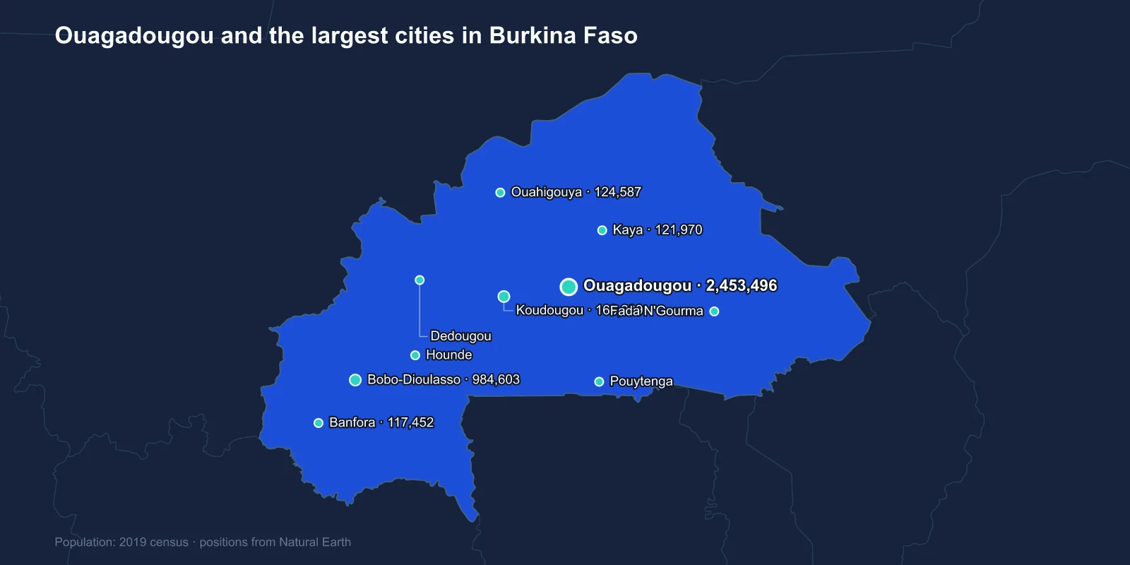
The largest cities in Burkina Faso are Ouagadougou (2,453,496), Bobo-Dioulasso (984,603), Koudougou (160,239), Ouahigouya (124,587), Kaya (121,970), Banfora (117,452), Pouytenga (96,469), Hounde (87,151), Fada N'Gourma (73,200) and Dedougou (63,617). These are 2019 census figures, which makes them among the most current in this series.
The distribution is unusually top-heavy even for the region. The two leading cities hold about 3.4 million people between them; the third-largest town has 160,000. There is essentially nothing in between.
A Capital That Grew Sevenfold in Forty Years
Ouagadougou has been the seat of the Mossi emperor, the Mogho Naaba, since the fifteenth century, which gives it a continuity that many West African capitals lack. The Mossi kingdoms resisted incorporation into the larger Sahelian empires for centuries, and the Mogho Naaba still holds ceremonial authority and real influence — the weekly Nab-Yiri ceremony at his palace continues, and he has mediated in more than one national political crisis.
The modern city is a different matter of scale. It held around 350,000 people in 1985 and has passed two and a half million, growing through informal settlement on the flat, dry plain in every direction, with the state periodically attempting to regularise or clear whole districts.
Water is the binding constraint. The city depends on a handful of reservoirs and on the Ziga dam some fifty kilometres away, and the supply is calibrated to a population considerably smaller than the one it now serves.
Bobo-Dioulasso Was the Capital of the Economy
Bobo-Dioulasso, in the south-west, was for much of the colonial and early independence period the larger and more important city. It sits in a wetter, more fertile region, and it was the industrial and commercial centre — the railway from Abidjan reached it first, and the manufacturing that existed was there.
The Grande Mosquee, built in 1880 in Sudano-Sahelian style with projecting wooden beams and conical buttresses, is the city's landmark, and the old quarter of Kibidwe predates the colonial town entirely.
Ouagadougou's growth as the administrative capital eventually overtook it, and the ratio is now more than two to one. Bobo retains a distinct identity, a reputation for music, and a rivalry with the capital that runs through Burkinabe cultural life.
The Railway That Made Both Cities
Burkina Faso is landlocked, and its economic geography is defined by the line to Abidjan. The railway was built north from the Ivorian coast in stages, reaching Bobo-Dioulasso in 1934 and Ouagadougou in 1954.
It carried cotton and livestock out and manufactured goods in, and it carried people: labour migration from Upper Volta to the Ivorian plantations was on a scale large enough that the French dissolved the colony entirely between 1932 and 1947, distributing its territory among neighbours partly to organise the supply of workers.
That history explains why millions of people of Burkinabe origin live in Ivory Coast, and why the Ivorian crisis over ivoirite in the 2000s had such direct consequences in Ouagadougou.
Cotton, Gold and What Pays for the Cities
Burkina Faso is among Africa's largest cotton producers, and the crop is grown across the west and south-west around Bobo-Dioulasso, Banfora, Houndé and Dedougou — which is why those towns appear on the list at all.
Gold has since overtaken it as the main export. A mining boom from around 2008 opened a series of industrial operations, and artisanal digging employs very large numbers of people across the country. Gold now accounts for the substantial majority of export earnings.
It has also become a security problem. Mining sites in the north and east are difficult to protect, and control of artisanal gold is a documented source of funding for the armed groups operating there.
The revenue question has also reshaped foreign policy. Since the 2022 coups the government has reviewed mining conventions, nationalised several assets and turned away from France towards Russia, alongside Mali and Niger. The three left the West African regional bloc ECOWAS together in 2025, a decision with direct consequences for the trade corridors these cities depend on.
Thomas Sankara and the Name
The country was called Upper Volta until 1984, when Thomas Sankara renamed it Burkina Faso — land of upright people — combining words from Mooré and Dioula, the languages of the two largest communities.
Sankara's four years in power produced a mass vaccination campaign, a literacy drive, land redistribution and a refusal of foreign aid on terms he considered demeaning, and they ended with his assassination in October 1987 in a coup led by Blaise Compaoré, who then governed for twenty-seven years.
Compaoré was removed by a popular uprising in Ouagadougou in October 2014 after attempting to extend his term, with the National Assembly burned. Sankara's remains were exhumed and Compaoré convicted in absentia of complicity in his murder in 2022, and a memorial has been built at the site in the capital.
The Insurgency Has Moved People Into the Towns
Since 2015 Burkina Faso has faced an insurgency by groups linked to al-Qaeda and the Islamic State, spreading from Mali across the Sahel region and into the north and east. Two coups in 2022 followed the military's failure to contain it.
The humanitarian effect has been severe. Around two million people have been internally displaced, and a large proportion of national territory is outside effective government control. Several towns, including Djibo in the north, have been under blockade for extended periods and supplied by helicopter.
The displacement has flowed into the cities on this list. Kaya and Ouahigouya in the north have absorbed very large numbers, in some cases approaching or exceeding their own resident populations, and Ouagadougou has taken more still. The 2019 census figures for the northern towns are therefore among the most out of date in this series, despite being recent.
The Film Festival in the Sahel
Ouagadougou holds an institution that has no equivalent anywhere else on the continent. FESPACO, the Panafrican Film and Television Festival, has been held there every two years since 1969 and is the largest African film festival in the world, with its own prize, the Etalon de Yennenga, named for the Mossi warrior princess of the founding legend.
The choice of a small, poor, landlocked capital as the centre of African cinema was deliberate cultural policy, reinforced under Sankara, and it has survived coups, insurgency and the collapse of the region's tourism. A bronze filmmakers' monument stands at one of the city's main junctions.
The capital is also the seat of the Mossi bronze and craft traditions and holds SIAO, a large pan-African handicrafts fair, in alternate years — the two events between them giving Ouagadougou a cultural profile that its economy alone would not support.
Koudougou, Pouytenga and the Market Towns
Koudougou, third on the list, is a cotton and textile town on the railway west of the capital, with a long history of student and trade-union militancy — the 2011 protests that shook the Compaoré government began there after a death in police custody.
Pouytenga, seventh, is unusual: a town with no administrative status of significance that grew purely as a market, sitting at a road junction east of the capital and functioning as one of the largest livestock and goods markets in the country.
Fada N'Gourma in the east is the seat of the Gourmantche kingdom and the main town of a region now heavily affected by the insurgency, while Banfora in the south-west sits beside sugar plantations, waterfalls and the domed rock formations that are among the country's few tourist attractions.
Dedougou, tenth, is known for the Festima mask festival, held every two years, which brings masking societies from across Burkina Faso and neighbouring countries to perform in the town. It is one of the largest gatherings of traditional masks anywhere in West Africa, and one of the few events that still draws visitors to the interior.
A Country With Very Little Water
Burkina Faso has no significant permanent river within its own territory for much of the year. The three Volta branches that gave the colony its name — the Black, Red and White Volta — rise here and flow south into Ghana, and several run low or dry outside the rains.
Every town on this list therefore depends on reservoirs, boreholes or seasonal storage. Ouagadougou's barrages are visible in the middle of the city, and the Ziga scheme was built because they were no longer enough.
The wider regional response has been the Great Green Wall, the plan to restore a belt of vegetation across the Sahel, in which Burkina Faso has been among the more active participants. The zai pitting technique for catching runoff on degraded land, revived by the farmer Yacouba Sawadogo in Yatenga province near Ouahigouya, has been adopted across the region and earned him a Right Livelihood Award.
Two Cities and a Displacement Crisis
Burkina Faso's urban system is a line along a railway: a Mossi royal capital that became a very large modern city, an older commercial centre in the wetter south-west, and a scatter of market towns that are now absorbing a displacement crisis far larger than they were built for.
More of the country’s peculiarities, Sankara’s renaming among them, are gathered in ten facts about Burkina Faso. The Ouagadougou profile covers the Mossi capital, and the Sahel and savanna behind it our Burkina Faso country guide.
