
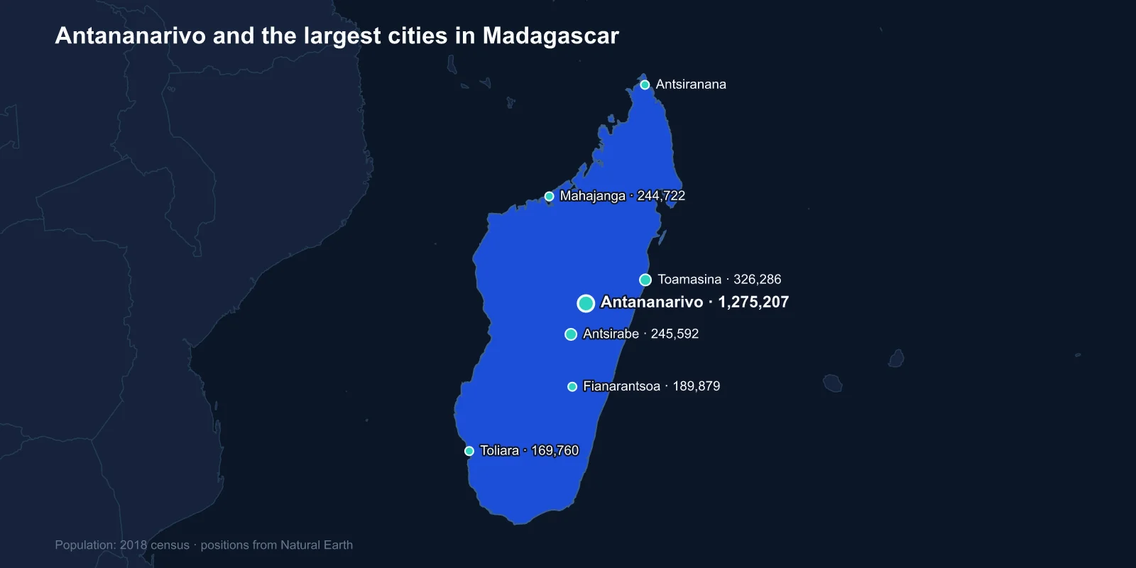
The largest cities in Madagascar are Antananarivo (1,275,207), Toamasina (326,286), Antsirabe (245,592), Mahajanga (244,722), Fianarantsoa (189,879), Toliara (169,760) and Antsiranana (131,165). These are 2018 census figures — the first full count the country had conducted since 1993.
Madagascar is the fourth-largest island in the world and holds about thirty million people, but its urban system is small and heavily concentrated. The capital is nearly four times the size of the second city, and only seven cities pass 100,000.
The Capital Is Not on the Coast
Almost every island nation puts its largest city on a harbour. Madagascar does not. Antananarivo sits roughly in the centre of the island, about 1,280 metres up on the Hauts Plateaux, some 200 kilometres inland from the nearest port.
The reason is political rather than commercial. The Merina kingdom, which unified most of the island in the nineteenth century, was a highland power, and its capital was a fortified royal hill. King Andrianjaka took the site around 1610 and garrisoned it with a thousand men — Antananarivo means the city of the thousand.
The Rova, the royal palace compound on the highest ridge, was the seat of Merina monarchs including Ranavalona I and the queens who followed her. It burned in 1995 in a fire whose cause was never established, destroying the palace and much of the royal collection; reconstruction has taken decades.
When the French took the island in 1896 they kept the highland capital and built a railway down to the coast rather than moving the administration to the sea.
A Railway, a Port and a Cyclone Coast
Toamasina, formerly Tamatave, is the principal port and the eastern terminus of that railway. It handles the large majority of Madagascar's containerised trade, and its fortunes are tied directly to the line up to the capital, which has been in poor repair for long periods.
The east coast is also the cyclone coast. Storms tracking west across the Indian Ocean strike Madagascar before they reach the African mainland, and Toamasina has been hit repeatedly — the island is among the countries most exposed to tropical cyclones anywhere, and the eastern rainforest belt takes the brunt.
The port also handles the output of the Ambatovy nickel and cobalt operation, whose ore travels 220 kilometres from the mine near Moramanga to a refinery on the coast through a buried slurry pipeline rather than by road or rail. It was among the largest foreign investments ever made in Madagascar, and its construction and repeated suspensions have moved Toamasina's economy noticeably in both directions.
The Highland Cities in Between
Antsirabe, third on the list, sits at about 1,500 metres south of the capital and was developed by Norwegian missionaries in the 1870s as a hill station around thermal springs. It is the coolest large town in the country and the centre of a temperate agricultural region growing apples, potatoes and dairy.
It is also an industrial town by Malagasy standards, with brewing, textiles and a tobacco works, and it is known for the pousse-pousse, the hand-pulled rickshaws that remain a principal means of transport through its streets.
Fianarantsoa, further south along the highland spine, is the old administrative capital of Betsileo country and a centre of Malagasy scholarship, with a university and a long Lutheran and Catholic educational presence. The vineyards around Ambalavao nearby produce most of the island's wine.
Its old town climbs a hill in tiers of brick houses with carved wooden balconies, a highland building style that owes more to nineteenth-century missionary influence than to anything on the coast, and which gives the central plateau towns a look quite unlike the rest of the island.
Three Coasts, Three Different Ports
Mahajanga on the north-west coast faces the Mozambique Channel and has the longest-standing Indian Ocean trading links of any Malagasy city. Swahili, Arab, Indian and Comorian merchants settled there over centuries, and the city is noticeably more Muslim and more cosmopolitan than the highlands.
Toliara in the south-west sits on a dry, spiny coast beside a large coral reef system, in a region of thorn forest and baobabs that is ecologically unlike anywhere else on the island.
Antsiranana, formerly Diego Suarez, occupies one of the finest natural harbours in the world at the northern tip — a vast enclosed bay that made it a French naval base and the objective of a British amphibious assault in 1942, launched to stop Vichy France handing it to the Japanese.
Why the Cities Are So Small
Madagascar is one of the least urbanised countries of its size, with somewhere around forty per cent of people in towns and the great majority still farming rice on terraced highland paddies or practising shifting cultivation in the forests.
It is also one of the few countries where average incomes are lower today than at independence in 1960. Repeated political crises — most severely the 2009 coup, which triggered years of suspended aid — have interrupted the investment that normally drives urban growth, and the transport network has deteriorated rather than expanded.
The road from Antananarivo to Toliara or to the far north can take days, and many district capitals are effectively unreachable by vehicle during the rainy season. That isolation keeps regional centres small.
The Vanilla Coast
The north-east of the island produces the large majority of the world's natural vanilla, grown around Sambava, Antalaha, Vohemar and Andapa — the SAVA region, named for its four towns. None of them is large enough to reach this list, and all of them are economically significant out of all proportion to their size.
Vanilla is the second most expensive spice in the world after saffron, because every flower must be hand-pollinated: the orchid's natural pollinator does not exist outside Mexico, and the technique of pollinating by hand was worked out by an enslaved twelve-year-old, Edmond Albius, on Reunion in 1841.
Price spikes have brought sudden cash into these towns and with it theft, night patrols in the plantations and violence over stolen pods. It is a reminder that Malagasy economic geography is concentrated in places too small to register as cities.
A Railway Built for One Crop
The line that matters most to Madagascar's interior is not the main freight route but the FCE, the Fianarantsoa-Cote Est railway, a 163-kilometre single track that drops from the highlands to the port of Manakara through forest, over more than sixty bridges and through tunnels cut in the 1930s.
It carries coffee, bananas and lychees from valleys that have no usable road at all, and for tens of thousands of farmers along it the train is the only way to get a crop to market. It has broken down and been repaired repeatedly, and each closure has measurable effects on the villages it serves.
An Island That Is Not Really African
The Malagasy language belongs to the Austronesian family, and its closest relatives are spoken in Borneo, roughly 7,500 kilometres away. Madagascar was settled by seafarers from island Southeast Asia, most likely between 1,500 and 2,000 years ago, with later arrivals from the East African coast.
That inheritance is visible in the cities. Highland rice terraces, wooden house construction, outrigger canoes on the coast and the famadihana reburial ceremonies all have Southeast Asian parallels rather than continental African ones. The highland Merina and coastal populations differ visibly in ancestry, and the political tension between them has been a constant since the nineteenth century.
What the 2018 Census Settled
Between 1993 and 2018 Madagascar had no census, and estimates of the national population varied by several million. The 2018 count produced a total of 25.7 million, and it also confirmed something that had been suspected: urban growth had been slower than projections assumed.
The figures in this list are therefore unusually trustworthy for the region — a real enumeration rather than a projection — though they are now several years old and the capital in particular has continued to expand into the rice paddies of the surrounding plain.
That expansion carries a specific risk. Antananarivo sits above a floodplain, the lower districts flood in most rainy seasons, and each hectare of paddy built over reduces the storage that protects the rest of the city.
The drainage system that protects the lower city is the Ikopa dyke network, parts of which date to Merina engineering of the nineteenth century and were extended under the French. Maintaining it competes for money with every other municipal demand, and the consequence of deferring that maintenance is measured each year in flooded neighbourhoods rather than in a single dramatic failure.
Plague is the other recurring urban problem, and Madagascar reports more human cases than any other country. Outbreaks are usually rural and bubonic, but the 2017 epidemic was unusual in being largely pneumonic and concentrated in Antananarivo and Toamasina, spreading person to person through exactly the dense districts that the city's growth keeps adding to.
A Kingdom That Stayed Inland
Madagascar's urban ranking is the map of a highland kingdom that kept its capital in the interior, a railway running down to one port, and a handful of coastal towns facing three different seas — with very little in between.
The settlement history behind the Malagasy language is explained by the island’s position in the Indian Ocean, several thousand kilometres from its linguistic relatives. The Antananarivo profile covers the highland capital, and the forests and plateaux around it our Madagascar country guide.
