
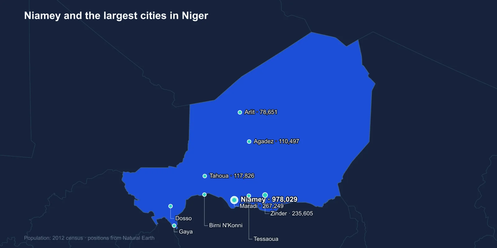
The largest cities in Niger are Niamey (978,029), Maradi (267,249), Zinder (235,605), Tahoua (117,826), Agadez (110,497), Arlit (78,651), Birni N'Konni (63,169), Dosso (58,671), Gaya (45,465) and Tessaoua (43,409). These are 2012 census figures; Niamey is generally estimated well above 1.3 million today.
Niger is one of the largest countries in Africa at about 1.27 million square kilometres, and roughly two-thirds of it is Sahara. Every town on this list except Agadez and Arlit sits in the narrow southern strip where the rainfall is enough to farm.
The Country Is a Band, Not an Area
Niger's habitable zone is a belt along the southern border with Nigeria and Benin, perhaps 150 to 300 kilometres deep, where the Sahel receives a short summer rainy season. Millet and sorghum grow there; north of it, they do not.
That belt holds the overwhelming majority of the population, and the line between farming and herding country shifts with the rains from year to year. When the rains fail the line moves south, pastoralists move their herds into cultivated areas, and the resulting friction is one of the oldest sources of conflict in the Sahel.
The cities are therefore strung out west to east along a single axis, following the RN1 highway and the border, rather than distributed across the territory.
Niamey Is a Colonial Creation
Unlike Zinder or Agadez, Niamey has no deep history. It was a small fishing village on the left bank of the Niger river when the French arrived, and it was chosen as the colonial capital in 1926 largely for its position on the river and its distance from the established power centres in the east.
It has grown from a few thousand people at independence in 1960 to close to a million and a half, and the growth has been driven by rural distress as much as by opportunity — each Sahelian drought has pushed another wave of people into the city.
The Niger river gives the capital something no other Nigerien city has: permanent surface water. The river rises in the Guinea highlands, loops north into the desert and comes back south, and its inland delta in Mali is what sustains the flow that reaches Niamey.
Zinder Was the Capital First
Zinder, third on the list, was the capital of the colony until 1926 and before that the seat of the Sultanate of Damagaram, a substantial Hausa state that traded across the Sahara and maintained its own cannon foundry.
The sultan's palace and the old walled quarter of Birni are still there, built in banco — mud brick rendered with earth — and decorated with the incised geometric patterns characteristic of Hausa architecture.
Zinder's loss of capital status to Niamey shifted the country's centre of gravity west, away from the Hausa east, and that reorientation remains a live feature of Nigerien politics.
Maradi and the Border That Does Not Matter
Maradi is the second city and the commercial capital, and its business is almost entirely conducted with Nigeria. The border is a few dozen kilometres away, and Kano — one of the largest cities in West Africa — is a short drive beyond it.
Groundnuts, cowpeas, cattle and manufactured goods move across in both directions, much of it informally, and the naira circulates as readily as the CFA franc. Maradi's merchants are more closely tied to Nigerian markets than to Niamey, and closures of the Nigerian border have hit the city harder than any national policy.
The surrounding Maradi region is also the most densely populated part of Niger, and it is where the country's very high fertility rate is most visible — Niger has recorded the highest birth rate in the world for years, with a median age under sixteen.
Agadez, and the Road Into the Desert
Agadez is the exception on this list: a desert city, at the southern edge of the Aïr Mountains, and the historic capital of the Tuareg sultanate.
Its old town is a UNESCO World Heritage Site, and the sixteenth-century mosque there has a minaret of mud brick studded with projecting wooden beams, rising about 27 metres — the tallest mud-brick structure of its kind anywhere.
Agadez was a caravan city on the trans-Saharan routes, and it remained a transit point in the modern era for an entirely different traffic: it became the main staging post for migrants travelling north towards Libya and the Mediterranean. A 2015 law criminalising the transport of migrants largely dismantled that economy and removed a substantial part of the town's income; the law was repealed in 2023.
Uranium at Arlit
Arlit exists because of uranium. The deposits north of Agadez were developed from 1968 by French interests, and the town was built in the desert to house the workforce, connected to the south by a road known as the uranium highway.
For decades Niger was among the world's larger uranium producers, and the ore fed French nuclear power stations. The relationship has been politically charged throughout — Nigeriens have long argued that the terms were extractive, and mining revenue is a persistent theme in the country's politics.
Arlit has also had the environmental consequences that follow open-pit and underground uranium mining in a place with no water: tailings piles, contaminated scrap and dust are documented problems.
The Tuareg Rebellions and the North
The north of Niger has seen repeated Tuareg insurgencies, in the early 1990s and again between 2007 and 2009, driven by grievances over marginalisation, drought policy and the distribution of uranium revenue from land the Tuareg consider theirs.
Those conflicts are part of why the country's urban system has stayed so concentrated in the south. Agadez and Arlit are the only substantial settlements in an area larger than France, and both have had periods of effective isolation.
The Towns on the River and the Highway
Dosso and Gaya sit south-west of Niamey along the road towards Benin, and Gaya is the border town for the corridor to the port of Cotonou — the route by which most Nigerien imports arrive, since the country is landlocked and has no railway.
Birni N'Konni and Tessaoua are highway towns on the RN1, market centres for their districts. Tahoua, fourth on the list, sits between the farming belt and the pastoral zone and is the main town for a large area of herding country.
Tahoua's region is also where the Cure Salee gathering is held each September at In-Gall, when Tuareg and Wodaabe herders converge on the salt pastures at the end of the rains. The Wodaabe courtship dances performed there, in which the men wear elaborate makeup and are judged by the women, are among the most photographed events in the Sahel.
Where the Dinosaurs and the Green Sahara Are
The Tenere desert in eastern Niger holds one of the richest fossil records anywhere. Expeditions there have recovered Nigersaurus, Ouranosaurus and the enormous crocodilian Sarcosuchus, animals from a period when the region was river floodplain rather than sand.
More recently, excavations at Gobero uncovered a graveyard used across two distinct populations during the African Humid Period, when the Sahara carried lakes and grassland and people fished in what is now open dune. The site is among the largest Stone Age cemeteries found in the desert.
None of this supports a town today, which is precisely the point: the emptiness of northern Niger is a recent condition, and the archaeology sits in country that no modern settlement pattern reaches.
A Landlocked Country With No Railway
Niger has effectively no functioning railway. A line from Cotonou in Benin was extended towards Niamey in the 2010s and the project stalled amid a dispute between the contractor and the state, leaving track laid but no through service.
Everything therefore moves by road, across distances that are punishing: Niamey to Zinder is roughly 900 kilometres, and Agadez is further still. Fuel, fertiliser and imported food all arrive by lorry from Cotonou, Lome or Nigerian ports, and each border closure or corridor disruption raises prices in every town on this list within a fortnight.
Why the Figures Are From 2012
Niger's last census was conducted in 2012. One planned for 2022 was delayed, and the July 2023 coup, the withdrawal of French and American forces, and the security situation across large parts of the country have made a new count difficult to organise.
What is not in doubt is the direction. Niger's population has roughly doubled since 2000 and continues to grow faster than almost anywhere else, which means every figure in this list is substantially below the current reality — Niamey most of all.
One Habitable Line
Niger's cities trace one habitable line across an enormous country: a colonial capital on the river, a Hausa sultanate that used to be the capital, a border city that trades with Nigeria rather than with its own government, and two desert towns that exist for caravans and uranium.
A dozen more oddities of the country, from its uranium to its dinosaur beds, are collected in ten facts about Niger. The Niamey profile covers the river capital, and the Sahara and Sahel that divide the country are mapped in our Niger country guide.
