
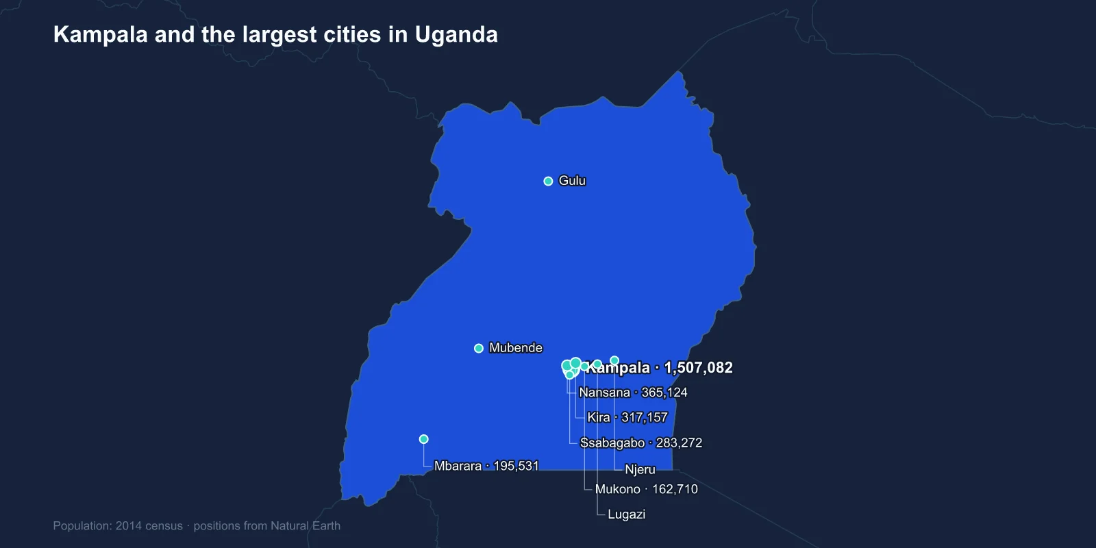
The largest cities in Uganda are Kampala (1,507,082), Nansana (365,124), Kira (317,157), Ssabagabo (283,272), Mbarara (195,531), Mukono (162,710), Njeru (159,549), Gulu (150,306), Lugazi (114,524) and Mubende (103,473). These are 2014 census figures, the most recent national count.
That list is misleading unless you know one thing: Nansana, Kira and Ssabagabo are not independent cities. They are suburbs of Kampala, sitting in the surrounding Wakiso district, and they appear separately only because of where the municipal boundary falls.
The Capital Is Much Bigger Than It Looks
Kampala Capital City Authority covers a relatively tight area that has not expanded to match the city's actual growth. Everything beyond it is administratively a different place, which is why a ranking of Ugandan urban centres puts three dormitory suburbs above every genuine regional town in the country.
Add the contiguous built-up area together and the Greater Kampala Metropolitan Area held well over three million people at the 2014 count, and is generally estimated above four million now. The city proper has been growing slowly; the ring around it has been growing very fast, because that is where land is available and where new arrivals can afford to build.
The practical effect is a commuting problem. Hundreds of thousands of people travel into a small central area each morning, largely by shared minibus taxi and by the motorcycle taxis known as boda-bodas, on a road network laid out for a far smaller city.
Built on Hills, Named for Antelope
Kampala is traditionally described as built on seven hills, though the city long ago spread across a good many more. Each of the original hills carried a distinct function: Mengo the palace of the Kabaka, Namirembe the Anglican cathedral, Rubaga the Catholic cathedral, Kibuli the principal mosque, Old Kampala the first colonial fort, Makerere the university.
That arrangement is a readable map of how the country was assembled. A Bugandan royal capital, two competing Christian missions placed on facing hilltops after a period of religious conflict, a mosque on a third, and a colonial administration on a fourth.
The name itself is usually traced to the impala that grazed the area, which the Kabaka kept as a hunting reserve. The British rendered the Luganda phrase for the hill of the impala as Kampala.
Makerere, and Why It Matters to the City
Makerere University opened in 1922 as a technical school and became the leading university in East Africa, drawing students from Kenya, Tanzania and further afield through the 1950s and 1960s. Its alumni include several heads of state and a long list of the region's writers.
The university anchors a large part of Kampala's economy and its politics. Student politics at Makerere has been a reliable predictor of national political trouble for sixty years, and the surrounding neighbourhoods of Wandegeya and Kikoni exist largely to house and feed the student population.
Mbarara Is the Real Second City
Discount the Kampala suburbs and Mbarara, fifth on the list, is the largest genuinely independent urban centre in Uganda. It sits in the south-west in Ankole, historically a cattle-keeping kingdom, and it is the commercial hub for a region that supplies much of the country's milk and beef.
Mbarara is also the gateway to the route towards Rwanda and to the western national parks, and the dairy industry around it has grown into one of Uganda's more successful export sectors, shipping processed milk into Kenya and beyond.
Gulu and the Twenty-Year War
Gulu, eighth on the list, is the largest city of the Acholi north and its recent history is inseparable from the insurgency waged by the Lord's Resistance Army from the late 1980s until the mid-2000s.
At the height of the conflict the great majority of the rural population of the Acholi sub-region was living in displacement camps, and Gulu absorbed an enormous transient population, including the night commuters — children who walked into town each evening to sleep in shelters and bus parks rather than risk abduction from their villages.
The war ended in northern Uganda around 2006 and people returned to the land, but Gulu retained much of its growth. It is now a university town and the administrative centre for the whole north, and its development has become the measure of whether the region has caught up with the rest of the country.
Jinja, the Nile and the Dams
Njeru, seventh, sits on the west bank of the Nile directly across from Jinja, and the two function as one industrial area. This is where the White Nile leaves Lake Victoria, and it is the most heavily engineered stretch of river in the country.
The Owen Falls Dam, now called Nalubaale, was completed in 1954 and drowned the Ripon Falls that John Hanning Speke identified in 1862 as the source of the Nile. A second dam, Kiira, was added alongside it, and a much larger one at Bujagali was commissioned in 2012, flooding a set of rapids that had become the centre of Uganda's white-water rafting industry.
Jinja was Uganda's industrial capital in the first decades after independence, and the collapse of that industry under Idi Amin — particularly after the 1972 expulsion of the Asian community that owned much of it — is visible in the town's empty factory shells.
Entebbe, the Lake and the Airport
Entebbe does not make the top ten, but it carries more national weight than its size implies. It sits on a peninsula in Lake Victoria about forty kilometres from Kampala, and it was the seat of the colonial administration before independence — which is why State House and the international airport are both there rather than in the capital.
The airport is Uganda's only significant international gateway, and it is known worldwide for a single night in July 1976, when Israeli commandos landed and freed the hostages from a hijacked Air France flight held in the old terminal building. The raid is still taught as a case study, and the building still stands.
Lake Victoria also feeds the region economically. Nile perch processing plants along the Ugandan shore export to Europe, and the beaches and landing sites between Entebbe and Kampala support a fishing economy that employs far more people than the factories do.
The Boda-Boda Economy
No account of Ugandan urban life works without the boda-boda. The motorcycle taxis take their name from the bicycles that once ferried people across the no-man's-land between border posts — border to border — and they have become the circulatory system of every town on this list.
In Kampala they number in the hundreds of thousands and they are the main reason the city functions at all given its roads. They are also the main reason its hospitals have a dedicated trauma caseload, and successive attempts to regulate, register or organise the trade have run into the fact that it is one of the largest sources of employment for young men in the country.
The Sugar Towns and the Road East
Lugazi and Mukono sit on the highway between Kampala and Jinja, and both grew around agro-industry. Lugazi is a sugar town, built around one of the estates established by the Mehta family in the 1920s, and its fortunes have tracked the sugar industry through nationalisation, decline and return.
Mukono is closer in and increasingly functions as another part of the Kampala commuter belt, with a university of its own and a rapidly expanding residential fringe.
Mubende, tenth, sits on the road west and grew on a different trade entirely. Gold was found in the district in the 1980s, and the artisanal rush that followed drew tens of thousands of diggers into camps around the town before the government cleared the site in 2017 and handed the concession to a licensed operator. The town kept much of the population the rush brought in.
Kasese, the Rwenzori and the Copper Line
Kasese, twelfth, sits at the foot of the Rwenzori Mountains in the west — the Mountains of the Moon, whose glaciated peaks rise above 5,000 metres almost on the equator and are among the few permanent ice fields in Africa.
The town was built around the Kilembe copper mines and the railway line constructed to carry the ore, both of which declined sharply. Kasese now depends more on tourism to Queen Elizabeth and Rwenzori national parks, and on cross-border trade with the DR Congo through the Mpondwe crossing.
What the Numbers Do Not Capture
Uganda's 2014 census recorded about 34.6 million people. Current estimates put the country well above forty-five million, with one of the youngest age structures in the world and a median age under seventeen.
That growth has not been distributed evenly across this list. It has gone overwhelmingly into the ring around Kampala — the Nansana, Kira and Ssabagabo entries — and into a set of towns that were granted city status in 2020, including Gulu, Mbarara, Jinja, Fort Portal, Masaka, Mbale, Soroti, Arua, Lira and Hoima. Those designations changed the administrative map without changing the underlying concentration.
Being landlocked shapes all of this, as Uganda’s position in East Africa makes clear. The capital that three of these entries actually belong to is examined in the Kampala profile, and the lakes and mountains behind them in our Uganda country guide.
