
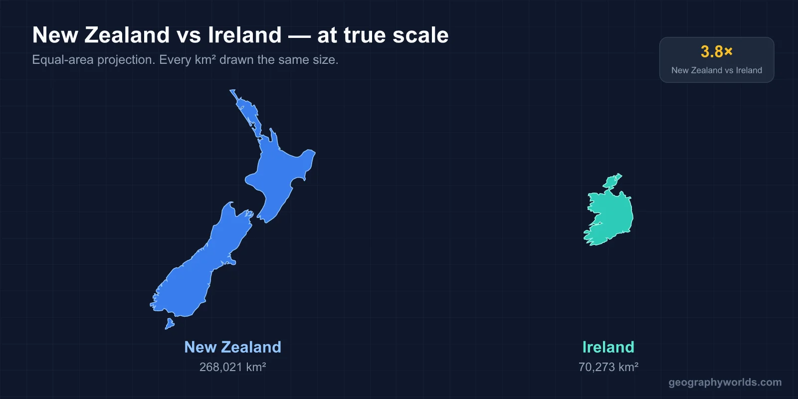
Ireland and New Zealand have almost exactly the same number of people, about 5.46 million in Ireland in April 2025 and an estimated 5.36 million in New Zealand in 2026, but New Zealand is almost four times the size, about 268,000 km² against 70,273 km². Ireland is by far the richer on paper, with an IMF-estimated nominal GDP per head of about $140,000 for 2026 against roughly $52,000 for New Zealand, although much of Ireland’s figure is profit booked by foreign multinationals. Wellington is New Zealand’s capital, though Auckland is its largest city; Dublin is both Ireland’s capital and its largest city. New Zealand’s official languages are English, Māori and New Zealand Sign Language; Ireland’s are Irish and English. (Ireland here means the Republic, not the whole island.)
The two are near-opposites on the globe, one on the western edge of Europe and the other in the southwest Pacific, yet they share a great deal: English-speaking majorities, a British colonial past, farm-based economies and rugby. The figures below set them side by side; the sections after the table take the largest gaps one at a time and explain where each comes from.
| Measure | New Zealand | Ireland |
|---|---|---|
| Area | about 268,000 km² | 70,273 km² |
| Population | about 5.36 million (2026 estimate) | 5,458,600 (April 2025 estimate) |
| People per km² | about 20 | about 78 |
| Nominal GDP per person (IMF, 2026) | about $52,000 | about $140,000 |
| Human Development Index (2023) | 0.938 (17th) | 0.949 (11th) |
| Highest point | Aoraki / Mount Cook, 3,724 m | Carrauntoohil, 1,039 m |
| Longest river | Waikato, 425 km | Shannon, 360–386 km by different measures |
| Largest lake | Lake Taupō, 616 km² | Lough Corrib, 176 km² |
| Capital | Wellington (largest city Auckland) | Dublin |
| Currency | New Zealand dollar | Euro (in use since 1999, cash since 2002) |
Ireland’s $140,000 GDP Figure and the Multinationals Behind It
The widest gap in the table is money, and it is also the most misleading. Ireland ranks second in the world for nominal GDP per person in the IMF’s 2026 estimates, and New Zealand 23rd. But Ireland’s GDP includes very large profits earned by foreign companies that are based in Ireland for tax and legal reasons and then flow back out. Foreign multinationals employ about a quarter of Ireland’s private-sector workers and pay around 80 per cent of its corporation tax, and about 80 per cent of those foreign multinationals are American. Ireland is the largest foreign base of Apple, Google, Microsoft and Facebook. In 2015, when Apple restructured its Irish subsidiary, Irish GDP officially grew by 26.3 per cent in a single year, a figure later revised to 24.6 per cent.
To see through this, Irish statisticians created a separate measure in 2017, modified gross national income (GNI*), which strips out those multinational flows, and the Irish government uses it for its own planning. On that basis the gap with New Zealand is far narrower. The UN’s Human Development Index, which combines income with health and education, puts the two countries close together: Ireland 11th in the world and New Zealand 17th.
New Zealand’s wealth is older and built on the land. The first shipment of refrigerated meat sailed for Britain aboard the Dunedin in 1882, and demand for meat and dairy in Britain and the United States gave New Zealanders higher living standards than Australians and Western Europeans in the 1950s and 1960s. The two countries’ economies turned on the same event in 1973: Ireland joined the European Communities on 1 January, alongside the United Kingdom, while British entry cut New Zealand’s biggest export market. By 1982 New Zealand had the lowest income per person of the developed countries surveyed by the World Bank, which led to the sweeping deregulation of “Rogernomics” from 1984. Their currencies point in the same two directions: Ireland switched to euro notes and coins in 2002 along with eleven other EU members, while the New Zealand dollar also circulates in the Cook Islands, Niue, Tokelau and the Pitcairn Islands.
Aoraki at 3,724 m Against Carrauntoohil at 1,039 m
New Zealand sits on the boundary of the Pacific and Australian tectonic plates, and that single fact explains its landscape. The Alpine Fault runs for about 600 km along the South Island and last produced a great earthquake, of magnitude about 8.1, in around 1717; uplift along it has raised the Southern Alps, which include 17 peaks above 3,000 m and more than 3,000 glaciers, the longest of them the 23.5 km Tasman Glacier. Aoraki / Mount Cook, the highest, was measured at 3,764 m in the 1880s; a fall of rock and ice from its summit on 14 December 1991 and two decades of erosion afterwards brought it down to 3,724 m, the height listed since 2014. The North Island’s volcanic plateau holds Lake Taupō, which fills the caldera left mainly by a supervolcanic eruption about 25,600 years ago.

Ireland lies far from any plate boundary, and its mountains are old, worn and low. The highest, Carrauntoohil, reaches 1,038.6 m in MacGillycuddy’s Reeks on the Iveragh Peninsula in County Kerry; ice-age glaciers carved its corries and ridges. The Irish pattern is a ring of coastal uplands around a low, wet central plain, crossed by the Shannon, which divides the west from the rest of the island and drains about a fifth of it. Glacial clays, bogs and lakes give that interior its character, where New Zealand’s is set by volcanoes and fault lines.

The difference in rainfall follows the same logic. Moist westerly winds strike both countries, but New Zealand’s Southern Alps wring out far more of it: annual rainfall in Fiordland ranges from about 1,200 mm at Te Anau to 8,000 mm at Milford Sound. For a closer look at the Irish side, our guide to Ireland’s geography covers the central plain and the mountains around it.
Nearly Four Times the Land for the Same Five Million People
With about 20 people per km², New Zealand is one of the emptier developed countries; Ireland, at about 78, is four times as crowded but still thinly settled by European standards. New Zealanders are nonetheless concentrated: 76 per cent live on the North Island, a third in the Auckland Region alone, and Auckland’s urban area had about 1.55 million people in June 2025. The South Island, larger than the North, holds under a quarter of the population, and Fiordland in its southwest has almost no settlement at all.
Much of the remaining land is pasture. New Zealand had about 24.4 million sheep in June 2023, down from a peak of 70 million in 1982 but still more than four per person, and the country is the world’s largest exporter of lamb. Ireland’s farm exports lean more on cattle, beef and dairy, and its largest city, Dublin, is also its seat of government. New Zealand separates the two roles: Auckland is the biggest city, but the capital moved to Wellington, on Cook Strait between the two main islands, in 1865, a status that rests on convention rather than any law. Our page on Wellington, New Zealand’s capital, explains how that came about.
Famine and Emigration in Ireland, Settlement in New Zealand
The two populations match today only by coincidence of opposite histories. Ireland was once much fuller. The area of today’s Republic held about 6.5 million people in the mid-1840s. During the Great Famine of 1845–1852 roughly a million people died and more than a million emigrated from an island of about 8.5 million, and its population fell by 20 to 25 per cent between 1841 and 1871. Ten years after its mid-1840s peak, the Republic’s area held about 5 million. Emigration then continued for more than a century, and the state recorded its lowest figure, 2.8 million, in the 1961 census. By the 2022 census it had recovered to 5,149,139.
New Zealand was among the last major lands on Earth to be settled. Polynesians arrived between about 1280 and 1350 and developed Māori culture. The Treaty of Waitangi, signed by British representatives and Māori chiefs on 6 February 1840, opened the way to British sovereignty and a colony in 1841, and immigration from Britain and Ireland followed. Some of the Irish emigrants the famine scattered reached New Zealand, settling mainly in Auckland, Canterbury and the West Coast, and today around one in six New Zealanders has some Irish ancestry. At the 2023 census 17.8 per cent of residents identified as Māori, and the largest iwi, or tribe, was Ngāpuhi of Northland, with 184,470 members.
Independence came by different routes. The Irish Free State was created on 6 December 1922 after the Anglo-Irish Treaty and a war with Britain, and the Republic of Ireland Act took effect on 18 April 1949. New Zealand moved gradually and without conflict with Britain: it became a dominion in 1907, adopted the Statute of Westminster in 1947 and passed the Constitution Act 1986. It still shares its monarch with the United Kingdom, a link Ireland ended when it became a republic in 1949.
Te Reo Māori and Irish: Official Languages Being Revived
Both countries give official status to an indigenous language that English pushed aside, and both are trying to bring it back. Irish is the “first official language” under Ireland’s constitution. In the 2022 census, 1,873,997 people, about 40 per cent, said they could speak it, but only 71,968 used it daily outside school, 20,261 of them in the Gaeltacht districts of the west such as the Aran Islands. Te reo Māori became an official language through the Māori Language Act 1987, after fewer than 20 per cent of Māori were left speaking it as native speakers by the 1980s; the revival began with Kōhanga Reo immersion preschools in 1982. In both countries, place names show the older language most clearly: Aotearoa for New Zealand and Aoraki for its highest peak, and Corrán Tuathail for Carrauntoohil. For more on the New Zealand peak, see our guide to Aoraki / Mount Cook.