

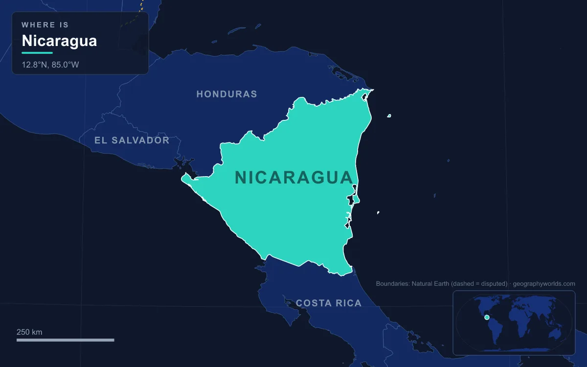
Nicaragua is the largest country in Central America, covering 130,370 km² between Honduras to the north and Costa Rica to the south, with coasts on both the Pacific Ocean and the Caribbean Sea. Its land falls into three physical regions: the Pacific lowlands, a hot plain about 75 km wide that holds a line of active volcanoes and the two great lakes, Lake Nicaragua and Lake Managua; the central highlands, a wedge of ridges between 900 and 1,800 m; and the Caribbean lowlands, the Miskito Coast, which cover more than half the country. The highest point is Mogotón, 2,085 m, on the Honduran border. The main rivers are the Río Coco, 841 km long and the longest river wholly within the Central American isthmus, and the 192 km Río San Juan, which drains Lake Nicaragua to the Caribbean. About 7.1 million people lived there in 2026, most of them on the Pacific side. Six named features explain most of that map.
Lake Nicaragua and Ometepe, an Island Built by Two Volcanoes
Lake Nicaragua, also called Cocibolca, is the largest freshwater lake in Central America at 8,264 km², roughly 160 km long and 75 km wide. It is shallow, reaching only about 26 m, and its surface sits 32.7 m above sea level. The lake fills part of a long structural depression, a rift that runs southeast from the Gulf of Fonseca to the Río San Juan, and its western shore is so close to the Pacific that only 19 km of low hills, the Isthmus of Rivas, separate the two. Yet the lake drains east, down the San Juan to the Caribbean, which is why the colonial city of Granada on its northwest shore was once, in practice, an Atlantic port.
The lake is best known for its bull sharks. Scientists first described them as a separate species, the Lake Nicaragua shark, but in 1961 comparisons showed they were the widespread bull shark. In the late 1960s researchers found that the sharks were not trapped at all: they jump the rapids of the San Juan much as salmon do, and tagged animals have travelled between the lake and the open sea in as little as seven days.
Ometepe, the largest island in the lake, is two volcanoes joined by a low isthmus. Its Nawat name means "two mountains". The island covers 276 km² and runs 31 km end to end. Concepción, on the northwest half, is a steep, symmetrical and still active cone rising to 1,610 m, high enough to make Ometepe the world's highest lake island; it stayed active for a year after an eruption began in December 1880, has erupted at least 25 times since 1883, and last erupted in May 2024. Maderas, on the southeast half, reaches 1,394 m, has had no historical eruptions, and holds a crater lake and one of the only cloud forests on Nicaragua's Pacific side.
Masaya Volcano's Santiago Crater and the Maribios Chain
Northwest of the lakes, the Pacific plain is broken by the Cordillera de los Maribios, a chain of young volcanoes built where the Cocos Plate slides beneath the Caribbean Plate. Their ash has made the surrounding plain some of the most fertile ground in Central America, and it is the most densely settled part of the country, home to more than half of all Nicaraguans. Earthquakes are the price: Managua was almost destroyed in 1931 and again in 1972.
Masaya Volcano, 20 km south of the capital, is a set of nested calderas and craters. The present Masaya caldera formed about 2,500 years ago in a basaltic eruption that expelled some 8 km³ of material, and new cones have since grown inside it. One of their pit craters, Santiago, degasses almost continuously, releasing large volumes of sulphur dioxide, and at times holds a lava lake. Only two lava flows have left the complex since the 16th century, one in 1670 that overflowed from a lava lake in Nindirí crater and one in 1772 from a fissure on the flank. Masaya became Nicaragua's first national park in 1979; the park covers 54 km².

Further up the chain stands Momotombo, the symmetrical cone on the shore of Lake Managua that appears on murals, stamps and matchboxes. An eruption in 1610 forced the inhabitants of León to move about 48 km west, leaving the ruins of León Viejo. Momotombo erupted again in late 2015 and early 2016, and a geothermal field lies on its southern flank. Near the village of Malpaisillo, Cerro Negro is the youngest volcano in Central America: a black cinder cone that first appeared in April 1850 and has erupted about 23 times since, most recently in 1999. At the northwest end of the chain, San Cristóbal, the backdrop to the town of Chichigalpa in Chinandega department, is the country's highest volcano at 1,745 m and one of its most active; its neighbour Casita buried a village under a landslide in 1998.
Mogotón and the Dipilto–Jalapa Highlands on the Honduran Border
East of the rift, the land rises into the central highlands, a triangle of ridges, oak and pine forest and deep valleys. Most of their rivers drain toward the Caribbean. The highest ground lies in the far north, in the Cordillera Dipilto y Jalapa along the Honduran frontier, where Mogotón reaches 2,085 m on the border itself, inside the Cordillera Dipilto y Jalapa national reserve. Above about 1,600 m, on and near the highest peaks, lies the tierra fría, where days average 22 to 24 °C and nights fall below 15 °C, a sharp contrast with the 30 to 33 °C afternoons of the lowlands.
The western slopes of the highlands sit in the rain shadow of the ridges and have drawn farmers from the Pacific side since colonial times. Nearly two-thirds of Nicaragua's coffee comes from the northern highlands north and east of Estelí, and tobacco grown in the same area has become an important export since the 1990s. The eastern slopes, facing the wet Caribbean winds, are covered in montane rainforest and are lightly settled. Clearing on steep ground has made erosion a serious problem.
Somoto Canyon, Where the Río Coco Begins
In Madriz department, close to where the Pan-American Highway crosses from Honduras, the Tapacalí and Comalí rivers meet and immediately enter a narrow gorge. This is Somoto Canyon, and the river that leaves it is the Coco. The canyon is thought to have been cut between 5 and 13 million years ago, in the Miocene, but it was not systematically explored until 2004, when a team of Czech and Nicaraguan scientists from the national geosciences institute, INETER, surveyed it. It was declared a national monument on 29 November 2006 and covers about 170 hectares, 125 of them in the canyon itself.

From the canyon the Coco flows 841 km through low mountains and then across the Caribbean plain to the sea at Cabo Gracias a Dios. Its middle and lower reaches form the border with Honduras; in 1960 the International Court of Justice awarded the northern part of the old Mosquito Coast to Honduras. Two days after Hurricane Felix made landfall in September 2007, the Coco stood more than 11 m above its normal level.
The Río San Juan and the Canal That Was Never Dug
The Río San Juan, known in colonial times as El Desaguadero, "the drain", carries the outflow of Lake Nicaragua 192 km east to the Caribbean. Upstream travellers meet a series of rapids, among them the Raudal del Castillo, or Raudal del Diablo. For much of its length the Costa Rican border follows the river's southern bank, and under the Cañas–Jerez Treaty the water belongs to Nicaragua, while Costa Rica may use certain stretches for commercial navigation.
Because the river, the lake and the narrow Isthmus of Rivas together form a low crossing of the continent, Nicaragua was long a rival to Panama for an interoceanic canal. During the California Gold Rush, Cornelius Vanderbilt's Accessory Transit Company was soon carrying 2,000 passengers a month up the San Juan by steamboat, across the lake and by stagecoach to the Pacific. To keep a competing canal out of other hands after Panama was chosen, the United States secured the rights to the route in the Bryan–Chamorro Treaty of 1916, which both countries rescinded in 1970. In June 2013 the National Assembly granted a 50-year concession to the Hong Kong-based HKND Group to build a canal through the lake. Works were ceremonially started in December 2014, but little followed amid protests over land seizures, and the concession was cancelled in May 2024.
Bosawás and the Miskito Coast Lowlands
East of the highlands, the Caribbean lowlands cover more than half of Nicaragua but hold a small share of its people. This is the Costa de Mosquitos, or Miskito Coast, named for the Miskito nation and long under British influence before it was incorporated into Nicaragua in 1894. Today most of it lies in two autonomous regions, the North and South Caribbean Coast Autonomous Regions, which together make up about 45 percent of the national territory. Around Bluefields, the main town, English is widely spoken alongside Spanish.
These are the wettest lowlands in Central America, receiving 2,500 to 6,500 mm of rain a year against 1,000 to 1,500 mm on the Pacific side. Floods regularly spread the Escondido, the Río Grande de Matagalpa, the Prinzapolka and the Coco across their floodplains, and hurricanes arrive from July to October: Joan in 1988 caused more than US$1 billion in damage, and Eta and Iota struck almost the same stretch of coast in consecutive weeks in November 2020. Soils away from the river levees are leached and poor.
Inland from the savanna are the great forests. The Bosawás Biosphere Reserve, designated by UNESCO in 1997, covers about 20,000 km², roughly 15 percent of Nicaragua, and is often described as the second-largest tropical rainforest in the Western Hemisphere after the Amazon. Its name joins three features: the Bocay River, Mount Saslaya and the Waspuk River. It overlaps the homelands of the Mayangna and Miskito peoples. In the south, the Indio Maíz Biological Reserve protects the forest that continues across the San Juan into Costa Rica. Both are under pressure from settlers moving east: some 130,000 people farm inside Bosawás, and land clashes between incoming settlers and Mayangna and Miskito communities turned deadly in 2020 and 2021.
Together the six features follow one west-to-east pattern, a crowded volcanic rift, drier highlands and a wet, thinly settled Caribbean plain, and that rift helps explain the rest of the geography of Central America. The geography of Lake Nicaragua covers the lake and its islands in more depth, and the capital's own setting on the shore of Lake Managua is described in our guide to Managua, Nicaragua's capital.