

The Oresund (Oresund in Danish, Oresund in Swedish), commonly called "The Sound" in English, is a strait separating Denmark's island of Zealand from the Skane region of southern Sweden. At its narrowest point between Helsingor (Denmark) and Helsingborg (Sweden), the strait is only 4 kilometers wide, though the main crossing between Copenhagen and Malmo spans approximately 16 kilometers.
Introduction
The Oresund is one of three Danish straits connecting the Baltic Sea to the Kattegat and ultimately the North Sea, and historically it has been the most important. For centuries, Denmark controlled both shores and levied the Sound Dues — a toll on all shipping passing through — making it one of the most lucrative customs points in European history. Today the strait is spanned by the iconic Oresund Bridge, one of Europe's engineering marvels.
Geography & Dimensions
- Narrowest Width: ~4 km (Helsingor-Helsingborg)
- Bridge Crossing Width: ~16 km (Copenhagen-Malmo)
- Length: ~118 km north to south
- Maximum Depth: ~27 m (main channel)
The Oresund runs roughly north-south for about 118 kilometers between the Kattegat in the north and the Baltic Sea in the south. Its width varies from 4 kilometers at the northern narrows to over 20 kilometers in the wider southern section. The strait is remarkably shallow, with a maximum depth of only about 27 meters in the navigable channel, which limits the draft of vessels that can transit.
The shallow depth is a legacy of the last ice age, when the region was covered by glaciers. The strait's floor is relatively flat with a sandy bottom. The island of Ven (Hven), famous as the site of Tycho Brahe's 16th-century astronomical observatory, sits in the middle of the strait between Copenhagen and the Swedish coast.
The Oresund Bridge
- Total Length: 15.9 km (bridge, island, tunnel combined)
- Bridge Section: 7.8 km cable-stayed bridge
- Tunnel Section: 4 km immersed tunnel (Drogden Tunnel)
- Opened: July 1, 2000
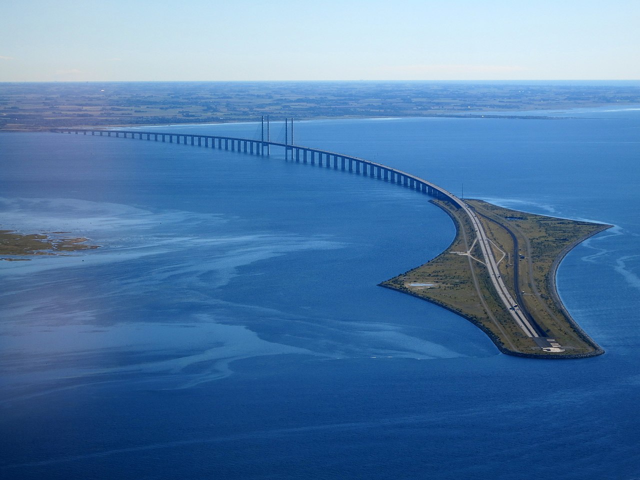
The Oresund Bridge (Oresundsbron) is a combined railway and motorway bridge-tunnel linking Copenhagen, Denmark, with Malmo, Sweden. The crossing consists of a 7.8-kilometer cable-stayed bridge from the Swedish coast to the artificial island of Peberholm, and a 4-kilometer immersed tunnel (the Drogden Tunnel) from Peberholm to the Danish coast near Copenhagen Airport.
The tunnel section was built to avoid interfering with air traffic at Copenhagen Airport and to maintain clear shipping lanes in the Drogden channel. Since opening in 2000, the bridge has transformed the Oresund region into an integrated economic zone. Over 70,000 people commute across the border daily, and the Copenhagen-Malmo metropolitan area functions increasingly as a single urban region of nearly 4 million people.
The Sound Dues
- Duration: 1429-1857 (428 years)
- Revenue: Up to two-thirds of Denmark's state income
- Abolished: 1857 after international pressure
- Compensation: Denmark received 30.5 million rigsdaler
From 1429 to 1857, Denmark levied the Sound Dues (Oresundstolden) on all merchant vessels passing through the strait. Since Denmark controlled both shores (Skane was Danish until 1658), no ship could enter or leave the Baltic without paying. At its peak, the Sound Dues generated up to two-thirds of the Danish crown's revenue, funding the construction of Kronborg Castle at Helsingor.
The dues were abolished in 1857 under the Copenhagen Convention, after sustained diplomatic pressure from the United States and major European trading nations. Denmark received 30.5 million rigsdaler as compensation from 13 nations. The Sound Dues records, preserved in the Danish National Archives, are an invaluable historical resource documenting over 1.8 million ship passages and the goods they carried.
Shipping & Environment
- Annual Vessel Traffic: ~37,000 transits through the strait
- Baltic Access: One of three Danish straits (with Great Belt and Little Belt)
- Ferry Traffic: Helsingor-Helsingborg ferry (~every 20 minutes)
- Environmental Status: Protected marine habitat areas
The Oresund carries substantial shipping traffic, with approximately 37,000 vessel transits per year. Together with the Great Belt, it provides the main shipping access to the Baltic Sea and the ports of Stockholm, Helsinki, Riga, St. Petersburg, and Gdansk. The shallow depth limits transit to vessels with a draft under about 8 meters, while deeper-drafted vessels must use the Great Belt crossing.
The strait supports important marine ecosystems. Its brackish waters, mixing Baltic and North Sea water, create unique habitats. The shallow areas around Ven island and along the Swedish coast host significant populations of harbor porpoises. The Oresund has been a marine protected area since the 1930s, with bottom trawling banned since 1932 — one of Europe's oldest such protections — resulting in unusually healthy fish stocks including large cod populations.
Key Facts
- The Oresund is only 4 km wide at its narrowest point between Helsingor and Helsingborg.
- The Oresund Bridge-tunnel (15.9 km) has linked Denmark and Sweden since 2000.
- The Sound Dues collected by Denmark from 1429 to 1857 were one of Europe's most lucrative customs tolls.
- Maximum depth is only ~27 m, limiting vessel drafts in the navigable channel.
- Over 70,000 people commute daily across the Oresund Bridge.
Fun Facts
- Kronborg Castle at Helsingor, built with Sound Dues revenue, is the setting of Shakespeare's Hamlet.
- The island of Ven in the middle of the Oresund was home to Tycho Brahe's famous astronomical observatory Uraniborg.
- Bottom trawling has been banned in the Oresund since 1932, making it home to some of the largest cod in Scandinavian waters.
- The Sound Dues records document over 1.8 million individual ship passages and are now a UNESCO Memory of the World candidate.
Final Thoughts
The Oresund is a strait whose importance far exceeds its modest dimensions. For over four centuries, Denmark's toll on shipping through The Sound financed a kingdom. Today, the Oresund Bridge has created one of Europe's most dynamic cross-border regions, proving that even the narrowest waterways can shape economies and nations on both sides of their shores.
Test Your Knowledge!
Think you know your straits and channels? Try our interactive quiz!
Play Water Body Quiz →