

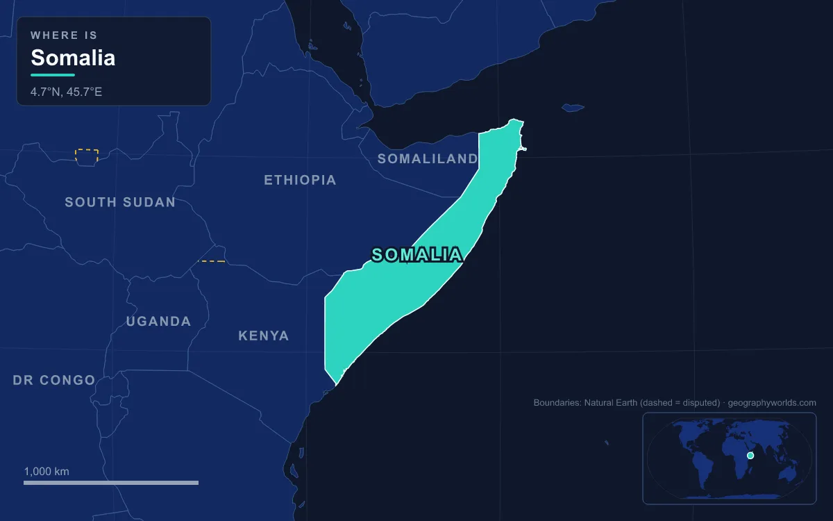
Somalia occupies the tip of the Horn of Africa, the easternmost country on the African mainland, covering 637,657 km² between the Gulf of Aden to the north and the Indian Ocean (locally the Somali Sea) to the east. Its coastline, at more than 3,300 km, is the longest of any mainland African country. The land falls into four broad physical regions: a hot coastal plain called the Guban along the Gulf of Aden; the steep northern highlands, the Karkaar, Ogo and Cal Madow ranges; the dry central plateaus of the Haud, the Nugaal Valley and the Mudug Plain; and the southern lowlands crossed by the country's only two permanent rivers, the Jubba and the Shabelle, both of which rise in the Ethiopian Highlands. The highest point is Mount Shimbiris, 2,460 m, near Erigavo in Sanaag; the lowest is sea level. Most of the country receives less than 500 mm of rain a year, and its estimated population of over 19 million is concentrated along the rivers, on the coast and in Mogadishu. Six features explain how it works.
The Guban Plain and the Heat of Berbera
The Gulf of Aden coast begins with a strip of scrub-covered desert that Somalis call the Guban, meaning "scrub land". It is about 12 km wide in the west and narrows to as little as 2 km farther east, squeezed between the sea and the foot of the mountains. Broad, shallow watercourses cross it, but for most of the year they are beds of dry sand. When rain does fall, low bushes and grass clumps revive quickly and nomads bring their herds down to graze for a few weeks.
Berbera, the main port on this coast, shows what the Guban means in practice. Its climate is classified as hot desert: average highs stay above 40 °C through June, July, August and September, and summer nights rarely drop much below 30 °C. Annual rainfall averages only about 52 mm, spread over five to eight rainy days, while the humidity off the gulf stays high, so apparent temperatures climb further still. The northern coastal plain as a whole can pass 45 °C in July.
Berbera lies on the coast administered by Somaliland, which declared independence in 1991 and governs itself from Hargeisa; Somalia's federal government regards the territory as part of Somalia, and most countries have not recognised the declaration.
Mount Shimbiris and the Cal Madow Escarpment
Inland from the Guban the ground rises abruptly to north-facing cliffs. These dissected highlands form the Karkaar ranges, which run from the Ethiopian border in the west almost to the tip of the Horn. Their crest averages about 1,800 m south of Berbera and holds at 1,800 to 2,100 m for much of the way east. The highest section, around Erigavo in the Sanaag region, is the Cal Madow range, and its summit is Mount Shimbiris at 2,460 m. Shuttle Radar Topography Mission data suggests the older, often-quoted figure of 2,416 m understated it.
Height changes everything here. The Cal Madow forest belt receives around 750 to 850 mm of rain a year, several times the national norm, topped up by fog and winter rain blowing off the gulf. That moisture sustains stands of African pencil cedar (Juniperus procera) and box (Buxus hildebrandtii), and the range holds roughly 1,000 plant species, about 200 of them found nowhere else. Botanists have found plants there with Mediterranean links, including a wild carob relative, and a 1995 Uppsala University survey turned up about eight new species. Wildlife includes the Warsangli linnet, a finch found only in Somalia, and the beira antelope. Close to Erigavo, Daallo Mountain protects part of the same limestone and gypsum escarpment, where the scarp summit gets about 650 mm of rain and some trees are thought to be more than 1,000 years old.
The contrast between scarp and coast is the widest in the country: the region that bakes at 45 °C in July on the plain can see frost in the highlands in December.
Cape Guardafui and Ras Hafun, the Tip of the Horn
The northern mountains run east until they end in sheer cliffs at Cape Guardafui, known in Somali as Raas Caseyr. The cape, at about 11°49′N, is the apex of the Horn of Africa, the corner where the Gulf of Aden turns into the open Indian Ocean. The Greeks called it Aromata promontorium, and the first-century Periplus of the Erythraean Sea described trading settlements along this coast. The modern name is usually traced to the lingua franca of late medieval Mediterranean sailors, in which guarda fui meant "look and escape", a warning about a coast where ships were often wrecked.
The strait beyond it, the Guardafui Channel, separates Somalia from the Socotra archipelago of Yemen. It is roughly 100 km wide between the cape and the island of Abd al Kuri, and about 240 km wide to Socotra itself. Its northern floor is Gulf of Aden oceanic crust more than 2,500 m deep. On the cape stands a stone lighthouse that Italy built in 1930 and named after Francesco Crispi.

Surprisingly, Guardafui is not the easternmost point of Africa. That distinction belongs to Ras Hafun, farther down the coast in the Bari region, a rocky promontory tied to the mainland at the town of Foar by a sand spit roughly 20 km long, 1 to 3 km wide and only 5 m above sea level. The fishing town of Hafun stands on the headland, and the line of latitude through it marks the boundary between the Guardafui Channel to the north and the Somali Sea to the south. Archaeologists have linked Hafun with Opone, a port named in the Periplus, and found Roman and Egyptian pottery there.
The Nugaal Valley: A Seasonal River Running to Eyl
South of the mountains the land drops in scarped ledges to a plateau with no permanent rivers. Somalis call this broken country of shallow valleys and dry beds the Ogo. Its eastern, driest part is cut by one long trough: the Nugaal Valley, which runs about 250 km along the Wadi Nugaal between limestone plateaus that stand 500 to 1,000 m above sea level on three sides. The valley spans the Nugal and Bari regions of Puntland and reaches west into Sool, Sanaag and Togdheer, which Somaliland claims.
The Nugaal River flows only during and after the April-to-June rains, together with the Togdheer watercourse that feeds its upper section, and it reaches the Somali Sea at the old port of Eyl. Rainfall here is only about 125 mm a year and the soils are salty, so crops barely grow. Instead the valley supports camels and goats, a few permanent wells along the watercourse beds to which herders return in the dry season, and wild frankincense and myrrh trees whose resin is still collected. Boswellia and Commiphora, the sources of those two resins, grow best in the arid northeastern highlands, the trade that made this coast known to the ancient world.
The Haud: Red Soil and Tiger Bush
Farther west, the Ogo plateau slopes gently south and merges into the Haud, a broad, undulating plateau of thorn bush and grassland covering an estimated 119,000 km². Its soil is red with iron. Seen from the air, dry scrub in this part of the Horn often grows in regular stripes separated by bare ground, a pattern ecologists call tiger bush and first described in British Somaliland in 1950. Only a small northern and eastern portion lies inside Somali territory; most of the Haud continues more than 60 km into the Somali Region of Ethiopia and merges there with the Ogaden.
The Haud has almost no permanent wells except on its western side. In the rainy seasons, however, its natural depressions fill to become temporary lakes and ponds, and it turns into some of the best grazing Somali herders have. That seasonal pulse drives Somali pastoral life, which follows four seasons named for the winds: the harsh dry Jilal from December to March, the main Gu rains from April to June, the dry Xagaa from July to September, and the short Dayr rains in October to December.
Britain, which had signed protection treaties with Somali clans in 1884 and 1886, recognised Ethiopian control over the Haud in an 1897 treaty with Emperor Menelik, administered it from British Somaliland during the Second World War, and returned it to Ethiopia in 1948, to the dismay of Somalis; a British attempt to buy the grazing lands back in 1956 failed.
The Shabelle and the Jubba: Somalia's Only Permanent Rivers
Southwestern Somalia is different because two rivers carry water from the Ethiopian Highlands across the plateau all year. They cut wide valleys as the land falls quickly toward the sea, and the coastal zone between the Mudug Plain and the Kenyan border averages only about 180 m above sea level.
The Shabelle runs about 1,820 km in all. It flows southeast toward Mogadishu but never reaches the sea at the capital. Near Balcad, about 30 km north of the city, it turns southwest and runs parallel to the coast for more than 85 km. Below Mogadishu it becomes seasonal, breaking into swamps and dry reaches, and in most years it is lost in the sand east of Jilib. Geologists think it once reached the ocean near Merca before its course shifted in prehistoric times. In very wet years the Shabelle breaks through to join the Jubba.

The Jubba forms where the Dawa and Ganale Dorya rivers meet at the Ethiopian border, then runs straight south through the region of Jubaland, named for it, to the Somali Sea near Kismayo. Its basin, shared with Ethiopia and Kenya, covers about 749,000 km². The German explorer Karl Klaus von der Decken wrecked his steamer Welf in rapids above Bardhere in 1865 and was killed there with three of his party; the Italian Vittorio Bottego finally traced the river's course in 1891.
The land between the two rivers is Somalia's only large farming region. The Ajuran state, which rose in the 13th century, dug irrigation channels from both rivers to plantations around Afgooye and Bardhere, growing sorghum, maize, beans and cotton. Today the same floodplains are the country's most arable zone and home to its largest settled farming population, and bananas grown along the lower Shabelle and Jubba are an important export, while East African mangrove swamps fringe the far southern coast toward Kenya. The rivers are also the main flood risk: when the Ethiopian Highlands have a heavy season, the Shabelle and Jubba overflow across the lowlands. You can follow the source of that water upstream in our guide to the Ethiopian Highlands, see how the northern coast fits into the Gulf of Aden, and read how the capital grew on this coast in our profile of Mogadishu.