
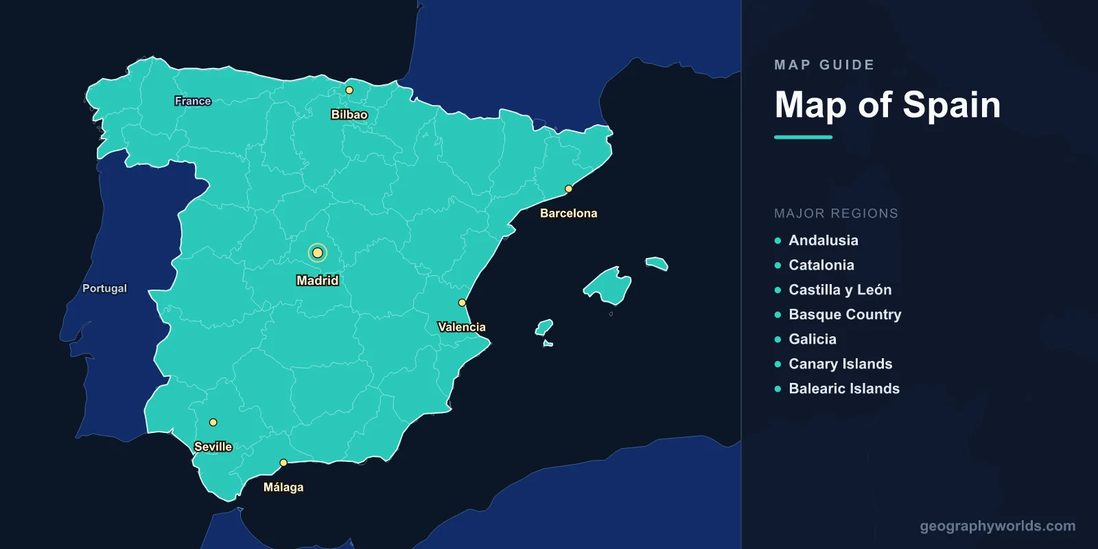
Spain sits in southwestern Europe on the Iberian Peninsula, spanning 505,990 km2 (195,360 sq mi) with a population of roughly 47.4 million. Its capital is Madrid (40.4168°N, 3.7038°W). A map of Spain shows 17 autonomous communities, two autonomous cities in North Africa (Ceuta and Melilla), and the Balearic and Canary island archipelagos. The country is the second-largest in the European Union by area and one of the most geographically varied, ranging from the snow-capped Pyrenees to the volcanic Canary Islands.
Where Is Spain on the Map?
Spain occupies about 85% of the Iberian Peninsula, the landmass it shares with neighboring Portugal. It is bordered by France and the micro-state of Andorra to the north along the Pyrenees, by Portugal to the west, and by the British territory of Gibraltar at its southern tip. Water surrounds the rest of the country: the Mediterranean Sea to the south and east, the Atlantic Ocean to the west and northwest, and the Bay of Biscay to the north.
This position at the meeting point of Europe and Africa, and between the Atlantic and the Mediterranean, has shaped Spain's climate, history, and culture for millennia. The Strait of Gibraltar, just 14 km wide at its narrowest, separates Spain from Morocco and is one of the world's busiest shipping lanes.

Key Facts
- Area: 505,990 km2 (195,360 sq mi)
- Population: 47.4 million (2024)
- Capital: Madrid (667 m elevation)
- Coordinates: 40.4637°N, 3.7492°W
- Highest Point: Mount Teide, 3,718 m (Tenerife, Canary Islands)
- Coastline: Over 4,964 km across the Mediterranean, Atlantic, and Bay of Biscay
- Currency: Euro (EUR)
The 17 Autonomous Communities
Spain is organized into 17 autonomous communities (comunidades autónomas), each with its own parliament and substantial self-governing powers, plus the two autonomous cities of Ceuta and Melilla. Together they form one of the most decentralized states in Europe. The complete list, with their capitals, is:
- Andalusia – Seville (largest by population; 87,268 km2)
- Aragon – Zaragoza
- Asturias – Oviedo
- Balearic Islands – Palma (Mallorca, Menorca, Ibiza, Formentera)
- Basque Country – Vitoria-Gasteiz
- Canary Islands – shared between Santa Cruz de Tenerife and Las Palmas
- Cantabria – Santander
- Castilla-La Mancha – Toledo
- Castilla y León – Valladolid (largest by area; 94,223 km2)
- Catalonia – Barcelona
- Extremadura – Mérida
- Galicia – Santiago de Compostela
- La Rioja – Logroño (smallest mainland community)
- Madrid – Madrid (the national capital)
- Murcia – Murcia
- Navarre – Pamplona
- Valencian Community – Valencia
These communities range from heavily urbanized regions like Madrid to sparsely populated rural areas like Extremadura. Four of them have co-official languages alongside Spanish: Catalan (Catalonia, the Balearics, and Valencia), Galician (Galicia), and Basque (Basque Country and parts of Navarre).
Physical Geography and Terrain
The defining feature of Spain's interior is the Meseta Central, a vast elevated plateau that averages 600–700 m and covers roughly 40% of the country. This high tableland, tilted gently toward the Atlantic, is rimmed and crossed by mountain ranges that divide Spain into distinct climatic zones. The major ranges include:
- Pyrenees: A 430 km wall of peaks forming the border with France and enclosing Andorra.
- Cantabrian Mountains: Running parallel to the northern Atlantic coast, trapping moist air and creating "Green Spain."
- Sistema Central: Splitting the Meseta and rising just north of Madrid.
- Sierra Nevada: Home to mainland Spain's highest peak, Mulhacén (3,479 m), near Granada.
The overall result is that Spain is, after Switzerland, one of the most mountainous countries in Europe by average elevation. Climates vary dramatically across these zones: a wet oceanic north, a hot-summer Mediterranean coast, a dry continental interior, and a near-subtropical climate in the Canary Islands and parts of the south.
Rivers, Coasts, and Natural Features
Spain's rivers drain into two great basins. Most flow westward to the Atlantic; the most important Mediterranean-bound river is the Ebro.
- Tagus (Tajo): The longest river on the Iberian Peninsula at 1,007 km; rises in Spain and reaches the Atlantic at Lisbon.
- Ebro: The longest river entirely within Spain at 930 km; flows to the Mediterranean, where its growing delta extends seaward each year.
- Duero, Guadiana, and Guadalquivir: Major Atlantic-draining rivers; the Guadalquivir is navigable inland to Seville.
Spain has more reservoirs than any other European nation—over 1,200—reflecting the need to store water in a largely dry interior. Its coastlines are equally varied: the rugged Costa Brava and sun-baked Costa del Sol on the Mediterranean, the cool Atlantic shores of Galicia, and the wetlands of Doñana National Park, an internationally vital stopover for migratory birds.
Major Cities
Spain's population clusters along the coasts and around a few large interior centers. The leading cities are:
- Madrid: Capital and largest city; about 3.3 million; sits at 667 m in the center of the Meseta, making it one of Europe's highest capitals.
- Barcelona: About 1.6 million; Catalonia's capital and Spain's principal Mediterranean port, with a metro area exceeding 5 million.
- Valencia: Around 800,000; the third-largest city, on the eastern coast.
- Seville: About 690,000; the largest city in Andalusia, inland on the Guadalquivir.
- Málaga: Around 580,000; gateway to the Costa del Sol.
- Bilbao: About 345,000; the industrial and cultural hub of the Basque Country.
Islands and African Territories
Beyond the mainland, Spain governs two major archipelagos and two cities in Africa. The Balearic Islands—Mallorca, Menorca, Ibiza, and Formentera—lie in the western Mediterranean and are among Europe's most popular holiday destinations. The Canary Islands, a chain of seven main volcanic islands off the northwest coast of Africa, host Mount Teide (3,718 m), Spain's highest point and the tallest peak on any Atlantic island.
On the North African coast, the autonomous cities of Ceuta and Melilla share land borders with Morocco, making them the only EU territories on the African continent. This unusual geography underlines Spain's role as a bridge between two continents.
Frequently Asked Questions
How many regions does Spain have?
Spain is divided into 17 autonomous communities plus 2 autonomous cities (Ceuta and Melilla). Each autonomous community has its own parliament and powers over areas such as education, health, and culture. These communities are further subdivided into 50 provinces.
What is the capital of Spain and where is it located?
Madrid is the capital, located almost exactly in the geographic center of the country on the Meseta Central plateau at around 40.4°N, 3.7°W. At 667 m elevation it is one of the highest capital cities in Europe.
What is the highest mountain in Spain?
Mount Teide on the island of Tenerife in the Canary Islands is Spain's highest point at 3,718 m. The highest peak on the Spanish mainland is Mulhacén (3,479 m) in the Sierra Nevada near Granada.
Which countries border Spain?
On the Iberian Peninsula, Spain borders France and Andorra to the north, Portugal to the west, and Gibraltar (a British Overseas Territory) to the south. Its African cities of Ceuta and Melilla border Morocco, and the Strait of Gibraltar separates mainland Spain from Morocco by just 14 km.
Test Your Geography Knowledge!
Think you know your maps? Try our interactive geography games!
Play Geography Games →