
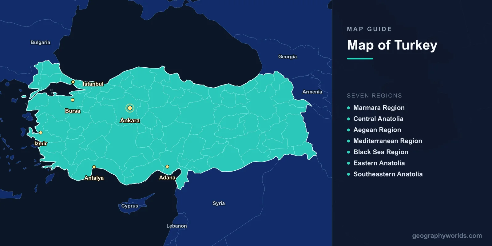
Turkey is a transcontinental country located at the crossroads of Europe and Asia, covering 783,356 km2 (302,455 sq mi) with a population of approximately 85.3 million. The capital is Ankara (39.9334°N, 32.8597°E). A map of Turkey shows 81 provinces, with 97% of its territory in Asia (Anatolia) and 3% in Europe (Eastern Thrace), separated by the Bosphorus Strait, Sea of Marmara, and Dardanelles.
Introduction
Turkey is bordered by eight countries: Greece and Bulgaria to the northwest, Georgia to the northeast, Armenia, Azerbaijan (Nakhchivan), and Iran to the east, and Iraq and Syria to the south. Its coastlines stretch along the Black Sea, Aegean Sea, and Mediterranean Sea, totaling over 7,200 km.

Geographic Overview
- Area: 783,356 km2 (302,455 sq mi)
- Population: 85.3 million (2024)
- Capital: Ankara
- Coordinates: 38.9637°N, 35.2433°E
- Highest Point: Mount Ararat, 5,137 m
- Coastline: 7,200 km
Anatolia is a high plateau rimmed by mountain ranges. The Pontic Mountains run along the Black Sea coast, the Taurus Mountains parallel the Mediterranean, and in the east these ranges converge into the rugged Armenian Highlands. The central Anatolian plateau averages 800–1,200 m in elevation with a semi-arid climate.
Major Regions
- Marmara Region: Istanbul and northwest; most urbanized and industrialized
- Central Anatolia: Ankara; steppe plateau; Cappadocia
- Aegean Region: Izmir; fertile coastal valleys; ancient ruins
- Mediterranean Region: Antalya; tourism; citrus agriculture
- Black Sea Region: Trabzon; lush green mountains; tea and hazelnut production
- Eastern Anatolia: Mount Ararat; Lake Van; high elevation; harsh winters
- Southeastern Anatolia: Göbekli Tepe; GAP irrigation project; Tigris and Euphrates
Turkey’s seven geographic regions reflect dramatic environmental variation. The coastal regions enjoy mild, wet climates, while the interior is continental and dry. Eastern Turkey is mountainous and sparsely populated, with elevations averaging over 1,500 m. The southeast is home to the headwaters of the Tigris and Euphrates rivers.
Major Cities
- Istanbul: 15.8 million; transcontinental city on the Bosphorus
- Ankara: 5.7 million; capital in central Anatolia
- Izmir: 4.4 million; Aegean port; third-largest city
- Antalya: 2.6 million; Mediterranean resort hub
- Bursa: 3.1 million; former Ottoman capital; silk and auto industry
- Adana: 2.3 million; Cilicia plain; agricultural center
Istanbul straddles the Bosphorus Strait, making it the world’s only major city on two continents. It was the capital of the Roman, Byzantine, and Ottoman empires for a combined 1,600 years. Ankara was chosen as capital in 1923 for its central Anatolian location, away from the vulnerable coastal periphery.
Bodies of Water & Natural Features
- Bosphorus: 31 km strait connecting Black Sea and Sea of Marmara
- Euphrates: 2,800 km total; rises in eastern Turkey; longest river in Western Asia
- Tigris: 1,850 km total; rises near Elazığ
- Lake Van: 3,755 km2; largest lake in Turkey; soda lake at 1,640 m
- Cappadocia: Volcanic tuff landscape; fairy chimneys; underground cities
- Pamukkale: Travertine terraces; hot springs; UNESCO World Heritage Site
Turkey’s rivers are vital water resources for the entire Middle East. The country’s Southeastern Anatolia Project (GAP) involves 22 dams and 19 power plants on the Tigris and Euphrates. Lake Van, a saline soda lake in eastern Turkey, is home to the endemic Van fish (Alburnus tarichi), which migrates into freshwater streams to spawn.
Bordering Countries
- Greece: 200 km land border; Aegean islands nearby
- Bulgaria: 269 km border in Thrace
- Georgia: 273 km northeastern border
- Armenia: 311 km eastern border
- Iran: 534 km border; Ararat region
- Iraq: 367 km southeastern border
- Syria: 899 km southern border; longest land border
- Azerbaijan (Nakhchivan): 17 km border; shortest
Turkey’s position at the junction of Europe, Asia, and the Middle East makes it a geopolitical pivot. The Turkish Straits (Bosphorus and Dardanelles) control the only maritime access between the Black Sea and the Mediterranean, a role of immense strategic importance throughout history.
Key Facts
- Turkey spans two continents; 97% in Asia, 3% in Europe.
- Mount Ararat (5,137 m) is the country’s highest peak and the legendary resting place of Noah’s Ark.
- Istanbul is the world’s only major city straddling two continents.
- Turkey’s coastline stretches over 7,200 km along four seas.
- The headwaters of both the Tigris and Euphrates rivers are in southeastern Turkey.
Fun Facts
- Turkey produces about 70% of the world’s hazelnuts, mostly along the Black Sea coast.
- Cappadocia’s underground cities could shelter up to 20,000 people during invasions.
- The ancient city of Troy, famous from Homer’s Iliad, is located in northwestern Turkey near the Dardanelles.
- Lake Van is one of the world’s few endorheic (no outlet) soda lakes.
Final Thoughts
Turkey’s map reveals a vast and geographically complex country bridging continents and civilizations. From the Bosphorus to Mount Ararat, from the Mediterranean’s turquoise coast to the stark Anatolian steppe, Turkey’s diverse landscape is matched by its rich history. Understanding its 81 provinces, mountain ranges, rivers, and strategic waterways is essential for any study of Eurasian geography.
Test Your Geography Knowledge!
Think you know your maps? Try our interactive geography games!
Play Geography Games →