

Geomorphologists recognise five basic types of wind-blown sand dune: crescentic (barchan) dunes, whose horns point downwind under a steady one-way wind; linear or seif dunes, long ridges that follow the average direction of two alternating winds; star dunes, pyramids with three or more arms built by winds from many directions; dome dunes, low rounded mounds without a slip face; and parabolic dunes, U-shapes whose arms point upwind because vegetation pins them down. A sixth form, the transverse dune, is what crescents become when sand is plentiful and they merge into ridges at right angles to the wind. Which type appears depends on three things: how steady the wind direction is, how much loose sand is available, and how much plant cover holds it. Examples range from barchans that moved more than 100 m a year in China’s Ningxia region to star dunes up to 500 m tall in China’s Badain Jaran Desert.
Ralph Bagnold’s Wind Tunnel and the Physics of Saltation
The modern explanation of dune shapes starts with a British army officer. Ralph Bagnold (1896–1990) spent his army leave exploring deserts, including a 1929 expedition from Cairo in Ford cars and lorries, and in 1932 made the first recorded east-to-west crossing of the Libyan Desert. Curious about how the sand behaved, he built a wind tunnel in the mid-1930s and measured how air moves grains, then checked the results in the field in the late 1930s. He finished his book, The Physics of Blown Sand and Desert Dunes, in 1939, and it was published on 26 June 1941. It founded aeolian geomorphology as a discipline; NASA later named the Bagnold Dunes on Mars after him.
Bagnold’s key process is saltation, from the Latin saltus, “leap”. Once the wind passes a threshold speed, it lifts grains off the surface. They fly in short, ballistic arcs and, on landing, splash other grains into the air, so the movement feeds itself. Heavier grains are nudged along the ground in a slower creep. Where something slows the wind, such as a pebble, a bush or a patch of rougher ground, grains drop out faster than they are picked up, and a pile begins.
Every dune then develops two faces. The upwind or stoss side is a long, gentle slope up which sand is pushed and bounced; on barchans it stands at about 15 degrees. At the crest the grains spill over into the sheltered lee, where they pile up until the slope reaches the sand’s angle of repose, about 30 to 35 degrees for medium-fine dry sand, and then slide down in small avalanches. That steep lee slope is the slip face. Sand eroded from the stoss side and deposited on the slip face makes the whole dune creep downwind. The orientation and number of slip faces, set by the wind regime, are what separate one type from another. Geologists also separate dunes from smaller ripples (under about 3 cm tall) and from draas, giant forms several kilometres long that can carry smaller dunes on their backs.
Barchans: Crescents That Raced Across Ningxia and Now Dot Mars
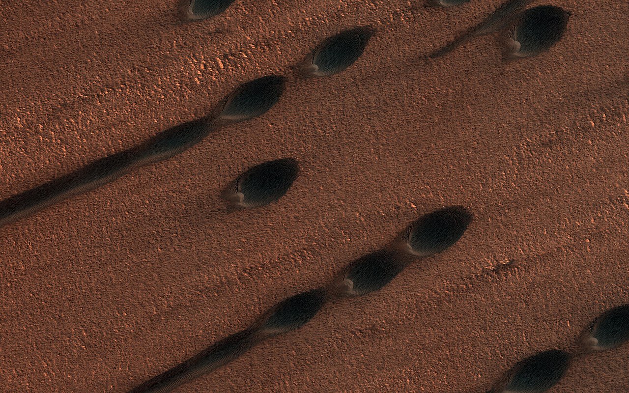
A barchan is the simplest dune: a single crescent, wider than it is long, with its horns pointing downwind and its slip face on the concave side. It forms where the wind blows consistently from one direction and sand is scarce, so dunes sit as isolated piles on a hard desert floor. Barchans are typically 9 to 30 m high and up to about 370 m wide at the base.
Some crescentic dunes move faster than any other type. Rates range from about one metre to 100 m a year; a group of crescentic dunes in China’s Ningxia region moved more than 100 m a year between 1954 and 1959, and similar speeds have been recorded in Egypt’s Western Desert. The largest crescentic dunes on Earth, with crest-to-crest widths of more than 3 km, are in the Taklamakan Desert. Barchans are not confined to Earth: they have been photographed on Mars, where the thin atmosphere still produces winds strong enough to move sand. A closer look at this one shape is in our guide to what a barchan dune is.
Transverse Ridges: When Barchans Merge in the Grand Erg Oriental
Add more sand to a field of barchans and they start to touch. Their horns join into wavy barchanoid ridges, and with still more sand those grade into transverse dunes: straight or slightly sinuous ridges lying across the wind, with the wind blowing at right angles to the crest. They look like waves frozen in sand. In the eastern Grand Erg Oriental, in Tunisia and the adjoining part of Algeria, interconnected barchanoid ridges form a net-like pattern with gentle windward slopes and steep lee slopes. The same form has been mapped beyond Earth: radar from the Magellan probe identified dune fields on Venus, Aglaonice at about 1,290 km² and Meshkenet at about 17,120 km², that appear to be mostly transverse.
Seif Dunes: Linear Ridges of the Simpson Desert and the Rub’ al Khali
Linear dunes are long, straight or gently wavy ridges with two slip faces and a sharp crest. They are also called seif dunes, from the Arabic word for “sword”. They form under bidirectional winds: two winds from different directions take turns, and the ridge grows along the resultant direction of sand movement rather than across either wind. Bagnold suggested that some seifs begin as barchans that move into a two-wind regime, so that one horn stretches out; others argue they form from spiralling vortices in a single wind. The debate is unresolved.
Seifs are the giants of length. In the Sahara they reach up to 300 m high and 300 km long. In the Rub’ al Khali, the Empty Quarter covering some 650,000 km² of Saudi Arabia, Oman, the UAE and Yemen, seifs stretch for nearly 200 km, and dunes there rise up to 250 m. Australia’s Simpson Desert, an erg of 176,500 km² across the Northern Territory, South Australia and Queensland, contains the world’s longest parallel sand dunes. These run north to south and are now static, held in place by vegetation. They rise from about 3 m in the west to around 30 m in the east, and the largest, Nappanerica or Big Red, is 40 m high. Drivers crossing the desert prefer to travel west to east, because the western slopes are gentler.

Star Dunes: Badain Jaran, the Grand Erg Oriental and Colorado’s Star Dune
Where winds blow from three or more directions over the year, sand cannot escape in any one of them, so dunes grow upwards rather than outwards. The result is a star dune: a pyramid with a high central peak and arms radiating from it, each with its own slip face. They include some of the tallest dunes on Earth. In the southeast of China’s Badain Jaran Desert, star dunes reach up to 500 m, possibly the tallest outside South America, with more than 100 spring-fed lakes lying between them.
The southern half of the Grand Erg Oriental in Algeria holds the largest accumulation of star dunes in the world, over an area of about 66,000 km². The biggest are 2.4 km across and 230 m high, and in the southwest of the erg they sit on top of older linear dunes, a sign that the wind regime changed as they grew. GPS measurements show that even star dunes migrate slowly. In North America, Great Sand Dunes National Park in Colorado contains the continent’s tallest dunes, up to 230 m, where the prevailing southwest winds have blown sand from old lake beds in the San Luis Valley towards the Sangre de Cristo Mountains. The field covers about 78 km² and holds an estimated 5 billion cubic metres of sand.

Dome Dunes and the Mega-Domes of Saudi Arabia’s Nejd
Dome dunes are round or oval mounds with no slip face at all. Most are small, only a few metres high, with smooth surfaces. A rarer kind, the mega-dome, rivals star dunes in size: the largest reach 150 m high in the Nejd region of Saudi Arabia and more than 1.5 km across in the Grand Erg Oriental, their surfaces covered by a dense network of smaller dunes so that from above they resemble a ribbed insect shell. They occur at the far upwind edges of sand seas, often next to groups of star dunes, and the difference between the wind regimes that build the two is still being researched.
Parabolic Dunes and the Sandblows of K’gari
Parabolic dunes reverse the barchan pattern. They begin as blowouts, where wind breaks through a patch of vegetated sand and scoops out a hollow. The bare sand is driven forward into a curved nose, while plants anchor the trailing arms, leaving a U or V shape whose arms point upwind. The longest arm known stretches 12 km. They are common on coasts and lake shores, where onshore winds blow beach sand inland into vegetation, and although their stability was long credited to plants, recent research points to water held in the sand as the main anchor.
K’gari, formerly Fraser Island, off Queensland, is the world’s largest sand island at 1,840 km² and a UNESCO World Heritage Site since 1992. Every hill on it was built by wind. Its sandblows are parabolic dunes stripped of vegetation; in 2004 there were an estimated 36. Driven by year-round southeasterly winds, they advance 1 to 2 m a year and can bury forest and block streams, and the island’s dunes reach 244 m. Its oldest dune system, dated at 700,000 years, is the world’s oldest recorded sequence.
Coastal dunes can be large as well as old. The Dune of Pilat near Arcachon in France, a foredune running parallel to the shore, is the tallest sand dune in Europe at 106.6 m (2018) and is slowly moving inland over the forest behind it. Desert dunes dwarf it: in Namibia’s Namib Desert, the dune nicknamed Big Daddy near Sossusvlei stands about 325 m high. Desert sand seas, by contrast, can take a million years or more to build their biggest dunes. For the record holders of every type, see our list of the highest sand dunes in the world.