
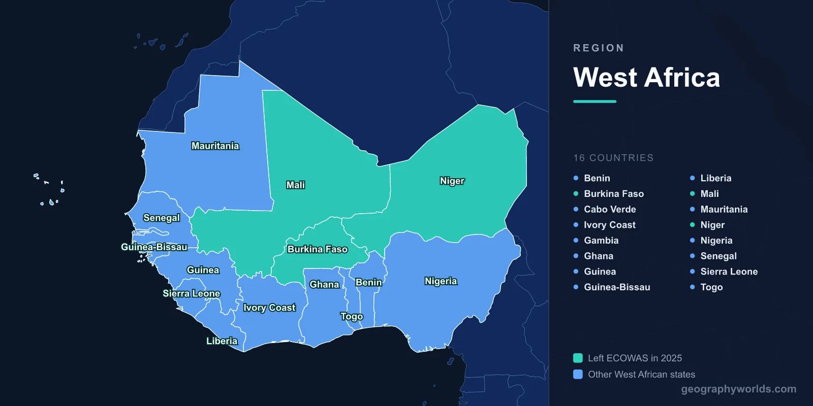
West Africa contains 16 sovereign countries: Benin, Burkina Faso, Cape Verde, Côte d'Ivoire, the Gambia, Ghana, Guinea, Guinea-Bissau, Liberia, Mali, Mauritania, Niger, Nigeria, Senegal, Sierra Leone and Togo. Twelve of them have Atlantic coastline; four are landlocked or Saharan. Together they hold well over 400 million people.

West Africa is the most populous region of the African continent and one of its most linguistically dense. It stretches from the Saharan interior of Mauritania and Mali to the humid coast of the Gulf of Guinea, and it contains both Africa's largest economy and some of the world's smallest island states. It is also a region whose political architecture changed significantly in the mid-2020s, which is worth understanding before looking at any older list.
All 16 West African Countries
The standard reference point is the United Nations geoscheme for Western Africa. By that definition there are 16 sovereign states, listed here with their capitals and approximate populations:
- Nigeria — Abuja | roughly 230 million | English
- Ghana — Accra | roughly 34 million | English
- Côte d'Ivoire — Yamoussoukro (official), Abidjan (seat of government) | roughly 31 million | French
- Niger — Niamey | roughly 27 million | French
- Mali — Bamako | roughly 24 million | French
- Burkina Faso — Ouagadougou | roughly 23 million | French
- Senegal — Dakar | roughly 18 million | French
- Guinea — Conakry | roughly 14 million | French
- Benin — Porto-Novo (official), Cotonou (seat of government) | roughly 14 million | French
- Togo — Lomé | roughly 9 million | French
- Sierra Leone — Freetown | roughly 9 million | English
- Liberia — Monrovia | roughly 5.5 million | English
- Mauritania — Nouakchott | roughly 5 million | Arabic
- The Gambia — Banjul | roughly 2.8 million | English
- Guinea-Bissau — Bissau | roughly 2.2 million | Portuguese
- Cape Verde — Praia | roughly 530,000 | Portuguese
Why Some Lists Say 17
You will occasionally see the count given as 17. That is usually because the list includes Saint Helena, Ascension and Tristan da Cunha, a British Overseas Territory in the South Atlantic that the UN geoscheme files under Western Africa. It is a territory rather than a sovereign country, so it does not belong on a list of nations. Some lists also stretch the region eastward to include Cameroon or Chad, both of which are conventionally classed as Central Africa. If you are counting sovereign states by the standard definition, the answer is 16.
Coastal West Africa: The Gulf of Guinea Belt
Twelve of the 16 countries have Atlantic frontage, and the coast is where the region's population and economic weight concentrate. The shoreline runs west to south-east: the Atlantic-facing bulge from Mauritania down through Senegal, the Gambia, Guinea-Bissau, Guinea, Sierra Leone and Liberia, then the coast turns east along the Gulf of Guinea past Côte d'Ivoire, Ghana, Togo, Benin and Nigeria.
Nigeria dominates on almost every measure. It is Africa's most populous country by a wide margin, holds roughly half of West Africa's total population on its own, and has the region's largest economy, built on oil from the Niger Delta plus a large services and entertainment sector. Lagos is among the fastest-growing megacities on Earth. Our guide to the countries that border Nigeria covers its four frontiers.
Ghana is the region's other coastal heavyweight and its most-cited political success story, with a long run of peaceful transfers of power. Its economy rests on gold, cocoa and, since 2010, offshore oil. Our Ghana country guide goes deeper.
Côte d'Ivoire is the world's largest cocoa producer and the economic anchor of francophone West Africa. Senegal, at the continent's westernmost point, has emerged as a regional diplomatic hub — see our Senegal country guide.
The Two Island and Enclave Oddities
- Cape Verde is the region's only island state, an archipelago roughly 570 kilometres off the Senegalese coast, with a largely creole culture and an economy built on tourism and remittances rather than agriculture.
- The Gambia is Africa's smallest mainland country, a narrow ribbon of land following the Gambia River and almost entirely surrounded by Senegal — a border shape that is a direct fossil of Anglo-French colonial bargaining.
The Sahel: Landlocked and Saharan West Africa
Four countries make up the region's dry northern tier: Mali, Burkina Faso and Niger are landlocked, and Mauritania has coastline but is overwhelmingly Saharan.
These are the countries of the Sahel, the semi-arid transition belt between the Sahara and the wetter savanna to the south. Rainfall here is low, highly seasonal and increasingly erratic, and the economies depend heavily on rain-fed agriculture and pastoralism. Mali and Niger are both mostly desert; their populations cluster along the Niger River, which loops improbably north into the Sahara before curving back south toward Nigeria.
Niger has among the highest fertility rates recorded anywhere, giving it one of the youngest and fastest-growing populations in the world. Mauritania sits at a cultural hinge, Arabic-speaking and oriented as much toward the Maghreb as toward Sub-Saharan Africa — which is part of why it left the region's main economic bloc in 2000.
ECOWAS — and the 2025 Sahel Split
The Economic Community of West African States was founded in 1975 by the Treaty of Lagos, with headquarters in Abuja. For decades it was one of Africa's more effective regional bodies, providing visa-free movement for citizens, a customs framework, and — unusually — a genuine peacekeeping capacity, deploying forces in Liberia and Sierra Leone during their civil wars and intervening diplomatically in several constitutional crises.
That architecture fractured in the 2020s. Following a run of military coups in Mali, Burkina Faso and Niger, and ECOWAS sanctions and threats of intervention in response, the three states announced their withdrawal in January 2024 and formalised their departure a year later, in January 2025. They have since aligned themselves in the Alliance of Sahel States. The practical consequences:
- ECOWAS membership now stands at 12 states rather than the 15 that older sources cite.
- Free movement across the Sahel–coastal boundary has become more complicated, which matters greatly for landlocked economies that route almost all their trade through coastal ports.
- Monetary arrangements are only partly affected: the three departing states remained in the West African CFA franc zone, which is a separate monetary union from ECOWAS itself.
- The "eco" — ECOWAS's long-planned single currency — has been repeatedly postponed, and the split makes near-term adoption less likely still.
Our dedicated ECOWAS guide covers the organisation's structure and history in more detail.
West Africa vs East Africa: How the Two Regions Differ
Comparing West Africa with East Africa brings out what is distinctive about each, and the contrasts are sharper than a glance at the map suggests.
- Relief — West Africa is largely low-lying: plains, plateaus and a coastal belt, with only modest highlands such as the Fouta Djallon in Guinea and the Jos Plateau in Nigeria. East Africa is defined by the Great Rift Valley, high plateaus and volcanic peaks like Kilimanjaro and Mount Kenya.
- Population weight — West Africa is more populous, and unusually concentrated: Nigeria alone accounts for roughly half the regional total. East Africa's population is spread more evenly across several large states.
- Colonial languages — West Africa is a patchwork of French, English, Portuguese and Arabic official languages, with francophone states in the majority. East Africa is predominantly anglophone, with Swahili serving as a genuine regional lingua franca — West Africa has no single equivalent.
- Trade orientation — West Africa faces the Atlantic and trades heavily with Europe and the Americas. East Africa faces the Indian Ocean, with deep historic and current ties to the Gulf, South Asia and China.
- Regional integration — the East African Community has pursued deeper political integration; ECOWAS went further on free movement earlier but has just lost three members.
Physical Geography: From Sahara Sand to Rainforest
West Africa's physical geography is best read as a set of horizontal climate bands running roughly east–west, with rainfall increasing steadily as you move south:
- Saharan zone — the far north of Mauritania, Mali and Niger. Hyper-arid, effectively uninhabited apart from oases and mining settlements.
- Sahel — semi-arid grassland and thorn scrub, with a short single rainy season. Pastoralism dominates.
- Sudanian savanna — wetter grassland with scattered trees, the region's main grain-growing belt.
- Guinean forest–savanna mosaic — a transitional band where woodland thickens.
- Coastal rainforest — the humid Upper Guinean forests of Liberia, Sierra Leone, Côte d'Ivoire and Ghana, a globally recognised biodiversity hotspot now heavily reduced by logging and cocoa expansion.
Two features cut across these bands. The Niger River, the region's great artery, rises in the Guinean highlands, arcs north-east into the desert, then swings south through Mali and Niger into Nigeria and the enormous Niger Delta. And Lake Chad, on the region's eastern edge, has shrunk dramatically since the 1960s — a shorthand example of the pressure Sahelian water systems are under.
Languages, Currencies and the Colonial Legacy
West Africa is one of the world's most linguistically diverse regions, with several hundred indigenous languages in active use. Major ones include Hausa and Fulfulde across the Sahel and northern Nigeria, Yoruba and Igbo in southern Nigeria, Akan in Ghana, Wolof in Senegal, and Bambara in Mali. Hausa in particular functions as a trade language across national borders.
Official languages, by contrast, are almost entirely colonial inheritances: French in nine countries, English in five, Portuguese in two, Arabic in Mauritania. The borders themselves are equally colonial — largely straight lines drawn in European capitals, cutting across ethnic and linguistic territories, which is why so many West African peoples are split between two or three states.
On currency, eight states use the West African CFA franc, historically pegged to the French franc and now to the euro. The rest run their own currencies: the Nigerian naira, Ghanaian cedi, Guinean franc, Gambian dalasi, Sierra Leonean leone, Liberian dollar, Cape Verdean escudo and Mauritanian ouguiya. That monetary patchwork is one of the practical obstacles to the deeper trade integration the region has been pursuing for half a century.
Test Your Knowledge!
Can you name all 16 West African countries and their capitals?
Play Geography Games →