

Nigeria borders four countries: Benin to the west (809 km), Niger to the north (1,608 km), Chad to the north-east (85 km, inside Lake Chad) and Cameroon to the east (1,975 km). Using Wikipedia's figure for each line, that is about 4,477 km of land border. To the south Nigeria's coast faces the Gulf of Guinea, where it shares a maritime border with São Tomé and Príncipe across the Bight of Bonny. All four were laid down in treaties between Britain, France and Germany from 1885 onwards, and the Cameroon line was later redrawn twice, by a UN plebiscite in 1961 and by a world court ruling in 2002. Taking the treaties in the order they were signed is the clearest way to see why the map looks as it does.
1885–1913: Britain and Germany carve the Cameroon line from the Cross River to Lake Chad
The oldest of Nigeria's borders is the eastern one. Britain had annexed Lagos in 1861 and set up the Oil Rivers Protectorate around Calabar in 1884; Germany claimed Kamerun in July 1884, the year the Berlin Conference opened to settle European claims in Africa. In April–June 1885 the two powers agreed a boundary in the south based on the Rio del Rey and the Cross River, and in 1886 they extended it inland as far as Yola on the Benue.
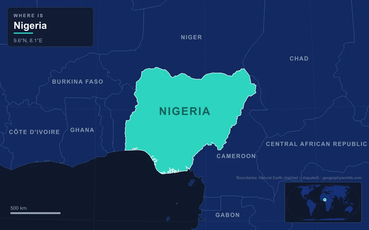
Arguments about where those rivers actually ran produced a revised treaty on 1 July 1890, clarified in April 1893, and a treaty of 15 November 1893 carried the line north to Lake Chad. Further detail on the lake section followed in 1906, and the whole boundary was confirmed by agreements in 1909 and 1913. The result is the longest of Nigeria's frontiers, 1,975 km through the Mandara Mountains, the Atlantika Mountains and along rivers such as the Benue, the Donga, the Cross and the Akwayafe. Nigeria's highest point, Chappal Waddi at 2,419 m, stands near this line in Taraba State, on the edge of Gashaka-Gumti National Park, and is also the highest peak in West Africa. Today the two main road crossings are Banki–Mora in the north and Mfum–Mamfe in the south.
1889–1914: the Dahomey line, the Okpara River and 142 concrete beacons
The western border with Benin, then the French colony of Dahomey, came next. France had signed a treaty with the Kingdom of Dahomey in 1851, set up a protectorate at Porto-Novo in 1863 and declared the colony in 1894. A rough Anglo-French line as far north as the 9th parallel was agreed on 10 August 1889 and refined on 12 October 1896.
The decisive document was the Anglo-French Convention signed in Paris on 14 June 1898, often called the Niger Convention, which settled the disputed areas of what became Northern Nigeria and extended the Benin line north to the Niger River. A further treaty of 19 October 1906 confirmed it, demarcation on the ground led to small changes in 1912, and an exchange of notes made them official in 1914. Between the Atlantic and the Okpara River, which forms the border for about 160 km, the line was marked by 142 concrete beacons joined by straight lines. By 2004–05 so many of those markers had gone missing that Benin and Nigeria had to re-demarcate parts of the border. Porto-Novo, Benin's official capital, lies close to the coastal end of the line, while Nigerian settlements such as Babana, Yashikera and Suya sit along the drier northern section.

1890–1910: from the Say–Barruwa line to the Komadougou Yobe
The northern border with Niger began as a sweeping diplomatic line. On 5 August 1890 Britain and France agreed that their spheres would be divided by a line from Say on the Niger River to Barruwa near Lake Chad. That line lay generally further north than today's border, and it was renegotiated in 1898, 1904 and 1906 before being fixed in its present position in 1910. France conquered what is now Niger in 1900 and ran it first as a military territory.
The finished border, 1,608 km long, leaves the Niger River at the Benin tripoint, runs north and then east in a broad, wavering arc, and follows the Komadougou Yobe River for its last stretch into Lake Chad. It cuts straight through Hausaland, so Hausa speakers form the majority on both sides. The main official crossings are Gaya–Kamba, Birni-N'Konni–Ilela, Dan-Issa–Katsina and Magaria–Mutum. Its eastern end, in Borno State near Diffa in Niger, has been badly affected by the Boko Haram insurgency, which has driven refugees across the frontier and left parts of it in a general state of lawlessness.
1900–1931: Lugard's amalgamation and the British Cameroons mandate
In 1900 the British government took over the lands of the Royal Niger Company and created the Northern and Southern Nigeria Protectorates. Under Governor Frederick Lugard these were joined in 1914 as the Colony and Protectorate of Nigeria, giving the colony the outer shape its borders still trace.
The First World War then reopened the east. British and French forces invaded German Kamerun in 1914 and defeated the Germans in 1916. On 22 July 1922 the League of Nations made Cameroon a mandate, with most of it going to France and two strips along the Nigerian border, the Northern and Southern Cameroons, going to Britain. A British Order in Council of 26 June 1923 put the British strips under Nigerian administration. The line between the British and French mandates was finalised on 9 January 1931, and in 1946 Britain fixed the boundary between its two strips, which today forms much of the Taraba State section of the border.
1960–1983: independence, the 1961 plebiscite and Lake Chad's 85 km line
All five countries became independent in 1960: Cameroon on 1 January, Dahomey on 1 August, Niger and Chad in August, and Nigeria on 1 October. The British Cameroons were still administered from Nigeria, so a UN plebiscite was held on 11 February 1961. The Muslim-majority Northern Cameroons voted to join Nigeria and became its Sardauna Province on 1 June 1961; the Southern Cameroons joined Cameroon on 1 October 1961. That vote fixed the Cameroon border in its present place.
The shortest border is the Chad line, an 85 km diagonal through Lake Chad between the Niger and Cameroon tripoints. Its origins lie in April 1900, when French columns linked France's West and Central African holdings at Kousséri; the line itself is a by-product of the neighbouring treaties, becoming a straight line once the Niger tripoint was fixed in 1910–12 and the Cameroon tripoint in 1931. At a meeting in N'Djamena in December 1962 the lake states agreed to keep the existing lines in the lake. Then the lake itself shrank. Fed mainly by the Chari River, it had covered about 28,000 km² in the nineteenth century, but open water fell from about 25,000 km² in 1960 to about 2,000 km² by 1980, and much of the border now crosses land, swamp and temporary islands. In 1983 a dispute over Nigerian fishers on the lake turned into fighting that killed 75 Chadian and nine Nigerian soldiers. Our page on the geography of Lake Chad explains why the lake changes so much.
1994–2024: Bakassi at the world court and the 2019 closure
The last big change came in the far south-east. The Bakassi peninsula, about 665 km² of mangrove islands between the Cross River estuary and the Rio del Rey, had been contested since 1913, and Nigerian and Cameroonian troops clashed there in 1981, 1994 and 1996. Cameroon took the case to the International Court of Justice in 1994, and on 10 October 2002 the court ruled that Bakassi belonged to Cameroon. Presidents Olusegun Obasanjo and Paul Biya signed the Greentree Agreement on 12 June 2006 to arrange the handover. The Nigerian Senate voted against the transfer on 22 November 2007, but it was completed on 14 August 2008, and a special transitional regime for residents ended in August 2013. The senators had argued that ceding territory breached section 12(1) of Nigeria's 1999 constitution. Resentment of the handover inside Bakassi later fed an armed conflict that has partly merged with the separatist Anglophone Crisis in western Cameroon. Estimates of Bakassi's population range from 150,000 to 300,000.

Since then the borders have been tested by people more than by treaties. The Boko Haram insurgency has driven refugees across the Niger, Chad and Cameroon lines, and the Banki–Mora crossing lies in the heavily affected far north. In the west, the Seme crossing on the Lagos–Cotonou coast road, about thirty minutes' drive from Badagry, has long been known for smuggling and for illegal checkpoints on the road leading to it; a new border-post facility opened there on 23 October 2018, and in August 2019 Nigeria closed its land borders with Benin and its other neighbours to stop rice smuggling. At sea, a treaty signed in Abuja on 21 February 2001 set up a joint development zone with São Tomé and Príncipe. On 27 June 2024 Cameroon and Nigeria agreed to settle their last disputed border points between themselves instead of going back to the court. The lines drawn in 1885–1913 now frame Nigeria's 36 states, from Lagos on the Benin border to Borno at Lake Chad.