
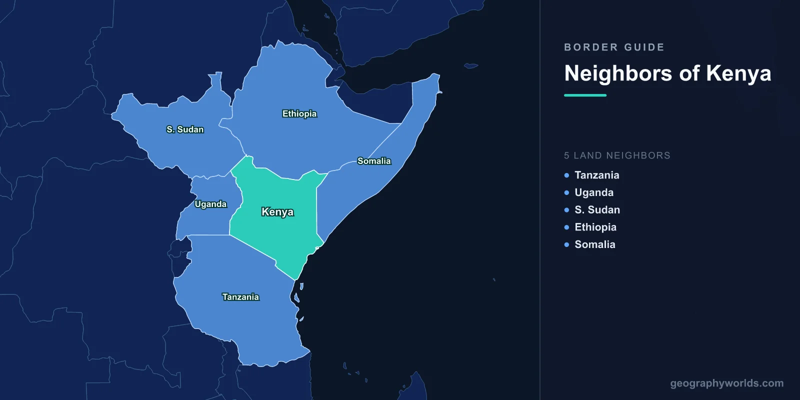
Kenya borders five countries: Ethiopia to the north, Somalia to the east, Tanzania to the south, Uganda to the west and South Sudan to the north-west. Its land borders total about 3,457 km. The longest is with Ethiopia (867 km) and the shortest with South Sudan (317 km), and Kenya also has 536 km of Indian Ocean coastline. Three of the five borders carry unresolved questions: the Ilemi Triangle with South Sudan, the tiny island of Migingo with Uganda, and the maritime boundary with Somalia.
| Neighbour | Border length | Main crossing |
|---|---|---|
| Ethiopia | 867 km | Moyale |
| Uganda | 814 km | Malaba, Busia |
| Tanzania | 775 km | Namanga |
| Somalia | 684 km | Officially closed |
| South Sudan | 317 km | Nadapal |
Figures are from the CIA World Factbook. The Uganda and Tanzania figures include boundaries across Lake Victoria, and the South Sudan length depends on where the Ilemi Triangle line is drawn.
The Ilemi Triangle: A Border Nobody Has Settled
Kenya's shortest border hides its largest territorial question. At the far north-west corner of the country, west of Lake Turkana, lies the Ilemi Triangle, an area of dry grazing land that is between about 10,000 and 14,000 km² depending on which map line is used. Colonial Britain drew several different lines there in the early twentieth century to protect the grazing of the Turkana people, who move their herds across it. Kenya has administered the triangle since colonial times, while South Sudan, and before it Sudan, has never formally given up its claim. Ethiopia's Nyangatom and Dassanech herders also use the land.
The triangle has little economic value, which is largely why the dispute has stayed quiet. But it is regularly the scene of violent cattle raiding between pastoral groups from several countries, and it means Kenya's map and South Sudan's still disagree.
South Sudan: The Newest Neighbour
Kenya has only bordered South Sudan since July 2011, when the south became independent from Sudan. Kenya played a large part in bringing that about. The talks that ended Sudan's long north–south civil war were held in Kenya, at Machakos and Naivasha, and the Comprehensive Peace Agreement signed in Nairobi in January 2005 set up the referendum in which southerners voted for independence.
For decades before that, Kenya's north-western corner served as the back door into southern Sudan. The small town of Lokichogio, about 30 km from the border, was the hub of Operation Lifeline Sudan, the United Nations-led relief effort launched in 1989 that flew food into the war zone. The Kakuma refugee camp, opened in 1992 to house young Sudanese refugees, including the thousands of boys who became known as the "Lost Boys of Sudan", has since grown into one of the largest refugee settlements in Africa, hosting people from South Sudan, Somalia, Ethiopia and beyond. The border crossing at Nadapal lies on the road that now links Kenya with Juba, South Sudan's capital, and much of South Sudan's imported fuel and food still comes through Kenya.
Uganda and the Island of Migingo
The border with Uganda, 814 km long, runs from Lake Victoria north over Mount Elgon, an extinct volcano rising to 4,321 m on the border, and on through dry country toward South Sudan. Lake Victoria itself is divided three ways: about 49 per cent belongs to Tanzania, 45 per cent to Uganda and only 6 per cent to Kenya.
Inside that small Kenyan share lies one of the world's oddest disputes. Migingo Island is a rock outcrop of only about a fifth of a hectare, less than a third of a football pitch, which is almost entirely covered with tin-roofed shacks housing several hundred fishermen, bars and shops. The waters around it are rich in Nile perch. Both countries claimed it in the 2000s. A joint survey in 2009 concluded that the island itself lies on the Kenyan side of the line, but Ugandan officials have continued to police the surrounding fishing waters, and the argument resurfaces regularly.
The Uganda border is Kenya's busiest trade frontier. The Malaba and Busia crossings carry most of Uganda's imports and exports to and from the port of Mombasa. That route follows the Uganda Railway, built by the British between 1896 and 1901 and mocked in London as the "Lunatic Express". Its construction in 1898 was halted for months by the two man-eating lions of Tsavo.
Somalia: The Closed Border
The 684 km border with Somalia runs almost straight north from the coast near Kiunga, through semi-desert inhabited on both sides by ethnic Somalis. That shared population has made it Kenya's most sensitive frontier. After independence in 1963, Somali secessionists in Kenya's north-east fought the Shifta War until 1967, seeking to join Somalia.
Since the collapse of the Somali state in 1991, the border has been a security problem. Kenya officially closed it in 2007, and in 2015 began building a barrier along parts of it, and in October 2011 sent troops into Somalia against the militant group al-Shabaab, which then struck inside Kenya, including at the Westgate shopping centre in Nairobi in 2013 and Garissa University College in 2015, where 148 people were killed. Near the border, the Dadaab camps, opened in 1991, have housed hundreds of thousands of Somali refugees and have been among the largest refugee camps in the world.
The two countries also dispute their boundary at sea. Somalia wanted it to run straight out from the coast; Kenya wanted it to follow the line of latitude due east, giving it more of the potentially oil-rich seabed. In October 2021 the International Court of Justice drew a line close to Somalia's position. Kenya rejected the ruling. Our guide to the countries that border Somalia covers the frontier from the other side.
Tanzania and the Kink Around Kilimanjaro
The 775 km border with Tanzania is mostly a straight line running north-west from the coast to Lake Victoria. The line was agreed between Britain and Germany in 1886, when this was the boundary between British and German East Africa. Near its middle it bends so that Kilimanjaro, Africa's highest mountain at 5,895 m, falls on the Tanzanian side. A popular story says Queen Victoria gave the mountain to her grandson, the future Kaiser Wilhelm II, as a birthday present. Historians have found no evidence for it. The bend was the product of diplomatic bargaining over spheres of influence.
The border cuts across one of the great wildlife corridors on Earth. Kenya's Masai Mara and Tanzania's Serengeti are a single ecosystem, and between about July and October more than a million wildebeest, with zebra and gazelle, move north across the border and back, famously crossing the Mara River. The Maasai people also live on both sides. The main road crossing, at Namanga, links Nairobi with Arusha.
Relations have not always been smooth. The first East African Community, which joined Kenya, Uganda and Tanzania in 1967, collapsed in 1977, and Tanzania then closed its border with Kenya until 1983. The community was re-founded in 2000 and now has eight members, as our guide to the East African Community explains.
Ethiopia: The Longest Border
Kenya's longest frontier, 867 km, crosses the arid north from Lake Turkana to the Somali border. Most of it was defined by an Anglo-Ethiopian treaty in 1907, though it was not fully demarcated on the ground until 1970. The main crossing is at Moyale, a town divided by the border, with Kenyan and Ethiopian halves. It lies on the highway that now links Nairobi with Addis Ababa, part of a planned corridor from the new Kenyan port at Lamu into Ethiopia and South Sudan.
At the western end, the border crosses the northern tip of Lake Turkana, the world's largest permanent desert lake. The Omo River, flowing in from Ethiopia, supplies around 90 per cent of the lake's water, so what happens upstream matters greatly to Kenya. Since Ethiopia completed the Gibe III dam on the Omo in 2016, Kenyan communities and scientists have warned that reduced flows and irrigation schemes could lower the lake and damage fisheries. We cover the lake itself in our guide to Lake Turkana.
How Kenya's Borders Were Drawn
The coast itself had a separate history: a ten-mile-wide coastal strip, including Mombasa, formally belonged to the Sultan of Zanzibar under British administration until it was transferred to Kenya at independence in 1963. Almost all of Kenya's land borders are the product of agreements between European powers, and between them and Ethiopia, in the thirty years after 1886. Straight lines through thinly populated land were easy to agree on paper, and they cut across the grazing ranges of pastoral peoples who had never recognised any boundary: the Maasai in the south, the Turkana and their neighbours in the north-west, and the Somali in the north-east. Since independence, Kenya, like other African states under a 1964 resolution of the Organisation of African Unity, has accepted its colonial borders as they were, on the principle that reopening them would cause more conflict than it would solve. Keeping those borders open to trade and closed to violence has shaped Kenyan policy ever since.