
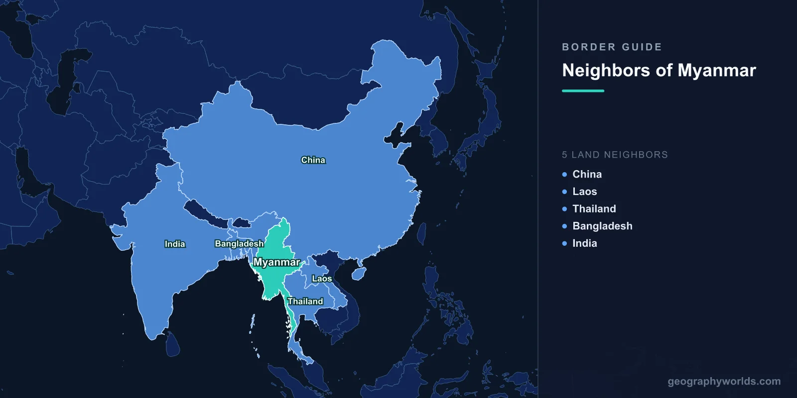
Myanmar (Burma) shares land borders with five countries: China to the north and northeast, Laos to the east, Thailand to the east and southeast, Bangladesh to the west, and India to the northwest.
Introduction
Myanmar's 6,522 km of borders traverse some of Asia's most rugged and inaccessible terrain. The country sits at the junction of the Indian subcontinent and Southeast Asia, with the eastern Himalayas and Arakan Mountains creating formidable barriers. Many border areas are controlled by ethnic armed organizations rather than the central government, making Myanmar's borders among the most complex in the world.
Overview of Myanmar's Borders
- Total Land Borders: 6,522 km
- Number of Neighbors: 5 countries
- Longest Border: China (2,129 km)
- Shortest Border: Laos (238 km)
Myanmar's borders follow mountain ranges, rivers, and jungle terrain that has historically isolated the country from its neighbors. The Shan Plateau, Kachin Hills, and Chin Hills create natural barriers, while the Irrawaddy, Salween, and Mekong rivers carve through the border regions. Much of the border area is covered in dense tropical or subtropical forest.
Myanmar's internal ethnic conflicts directly affect all its borders. The country has over 20 active ethnic armed organizations, many controlling territory along the borders with China, Thailand, and India. The 2021 military coup intensified these conflicts, causing refugee flows into all neighboring countries.
Northern and Eastern Neighbor: China
- Border Length: 2,129 km
- Key Features: Kachin State, Shan State, Ruili-Muse crossing
- Key Issue: Chinese influence in border states, drug trafficking
China's 2,129 km border runs through the mountainous terrain of Kachin and Shan states, areas with active ethnic insurgencies. The Ruili-Muse crossing is the main trade route, handling billions of dollars in commerce. Chinese economic influence in Myanmar's border states is enormous, with Chinese-funded dams, mines, and infrastructure projects throughout the region.
Drug production in the Golden Triangle region near the Chinese border remains a major concern. Myanmar is the world's second-largest opium producer and a major source of methamphetamine. Cross-border drug trafficking into China is a persistent challenge. China has occasionally sealed border sections during flare-ups of fighting in Kachin and Shan states.
Eastern Neighbors: Laos and Thailand
- Laos Border: 238 km
- Thailand Border: 2,416 km
- Key Features: Golden Triangle, Mekong River, Shan Plateau
Laos's short 238 km border runs through the Golden Triangle, where the Mekong River meets the Ruak River. This area was historically the world's largest opium-producing region. The border is mountainous and sparsely populated, with limited official crossing points.
Thailand's 2,416 km border is Myanmar's second-longest, running from the Golden Triangle south through the Dawna Range and Tenasserim Hills to the Andaman Sea. This border hosts hundreds of thousands of Myanmar refugees and migrants in Thailand. The Mae Sot-Myawaddy crossing is the busiest, and ethnic Karen, Shan, and Mon communities span both sides.
Western Neighbors: Bangladesh and India
- Bangladesh Border: 271 km
- India Border: 1,468 km
- Key Features: Arakan Mountains, Naf River, Chin Hills
Bangladesh's 271 km border runs through the Arakan (Rakhine) coastal hills and along the Naf River. The 2017 Rohingya crisis saw over 700,000 Rohingya Muslims flee across this border into Bangladesh's Cox's Bazar district, creating one of the world's largest refugee camps. The Rohingya situation remains unresolved, with Myanmar refusing large-scale repatriation.
India's 1,468 km border runs through the remote hills of Nagaland, Manipur, Mizoram, and Arunachal Pradesh. These Indian states have their own ethnic and insurgent dynamics, and some armed groups have historically used Myanmar as a refuge. India has conducted cross-border operations into Myanmar against insurgent camps. The Moreh-Tamu crossing connects to the India-Myanmar-Thailand highway.
Cross-Border Relations and Security
- Refugees: Millions displaced to neighboring countries
- Drug Trade: World's second-largest opium producer
- Post-Coup Crisis: Fighting near all borders since 2021
Myanmar's borders are among the most conflict-affected in the world. The 2021 military coup intensified fighting between the military (Tatmadaw) and ethnic armed organizations as well as new People's Defense Forces. Border areas in Kayah, Karen, Chin, Shan, and Kachin states have seen heavy fighting, displacing hundreds of thousands and causing cross-border spillover.
China maintains the most economic influence along Myanmar's borders, while India and Thailand focus on security concerns. All neighboring countries face challenges from drug trafficking, refugee flows, and the instability radiating from Myanmar's internal conflicts. The situation remains one of the most complex humanitarian and security crises in Asia.
Key Facts
- Myanmar borders 5 countries: China, Laos, Thailand, Bangladesh, and India.
- China's border at 2,129 km is Myanmar's longest.
- Over 700,000 Rohingya refugees fled across the Bangladesh border in 2017.
- The Golden Triangle, where Myanmar meets Laos and Thailand, is a major drug-producing region.
- Myanmar's ethnic armed organizations control significant border territory.
Fun Facts
- Myanmar's highest point, Hkakabo Razi (5,881 m), is near the border with China and India.
- The Salween River, one of the longest free-flowing rivers in the world, crosses from China into Myanmar.
- Myanmar's border with Laos at 238 km is one of the shortest in Southeast Asia.
- The ancient Shan States along the Chinese and Thai borders were semi-independent kingdoms until the 1950s.
Final Thoughts
Myanmar's five borders define one of Asia's most troubled states, where ethnic diversity, armed conflict, and geographic isolation create formidable challenges. From Chinese economic influence in the north to the Rohingya crisis on the Bangladesh border to the refugee camps along the Thai frontier, Myanmar's borders are at the center of some of Southeast Asia's most pressing humanitarian and security issues.
Test Your Knowledge!
Think you know which countries share borders? Try our geography games!
Play Geography Games →