
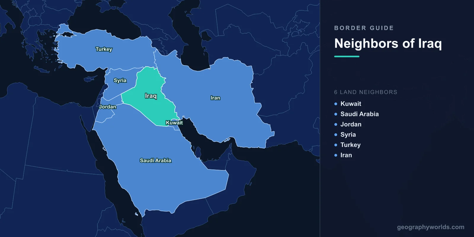
Iraq shares land borders with six countries: Kuwait and Saudi Arabia to the south, Jordan to the west, Syria to the northwest, Turkey to the north, and Iran to the east.
Introduction
Iraq's borders encompass the historic land of Mesopotamia, the fertile region between the Tigris and Euphrates rivers where some of humanity's earliest civilizations emerged. Today, these borders define one of the most strategically important and contested territories in the Middle East, shaped by colonial-era boundaries, oil politics, and decades of conflict.

Overview of Iraq's Borders
- Total Land Borders: 3,809 km
- Number of Neighbors: 6 countries
- Longest Border: Iran (1,599 km)
- Shortest Border: Jordan (179 km)
Iraq's borders are largely the product of British and French colonial line-drawing after World War I. The Sykes-Picot Agreement of 1916 and subsequent treaties created straight-line borders through the desert that often ignored ethnic, tribal, and geographic realities. The Iranian border, following the Zagros Mountains, is the most naturally defined.
Iraq's borders have been the focus of multiple wars and crises: the Iran-Iraq War (1980-1988), the invasion of Kuwait (1990), the Gulf War (1991), the Iraq War (2003), and the rise of ISIS (2014). Nearly every Iraqi border has seen significant military conflict in living memory.
Southern Neighbors: Kuwait and Saudi Arabia
- Kuwait Border: 254 km
- Saudi Arabia Border: 811 km
- Key Feature: Rumaila oil field, neutral zone
Kuwait's 254 km border with Iraq was the trigger for the 1990 Gulf War, when Saddam Hussein invaded Kuwait partly over disputed border oil fields including Rumaila. After liberation in 1991, the UN demarcated the border, moving it slightly northward. The border is now heavily fortified with trenches, berms, and military installations on both sides.
Saudi Arabia's 811 km border crosses the Arabian Desert, one of the most inhospitable environments on Earth. Much of this border is sparsely populated and difficult to patrol. Saudi Arabia has built a sophisticated border barrier system including fences, sensors, and surveillance technology to prevent infiltration. The Arar border crossing is the main commercial link between the two countries.
Western and Northwestern Neighbors: Jordan and Syria
- Jordan Border: 179 km
- Syria Border: 599 km
- Key Features: Western Desert, Euphrates River crossing
Jordan's 179 km border crosses the western Iraqi desert, a flat and arid landscape. The Trebil border crossing connects Baghdad to Amman and is a vital trade route. Jordan-Iraq relations have improved significantly since the 2003 Iraq War period, with plans for an oil pipeline from Basra to the Jordanian port of Aqaba.
Syria's 599 km border was effectively erased when ISIS controlled territory on both sides in 2014-2017, declaring a caliphate across the Sykes-Picot line. The border crosses the Euphrates River near the city of Al-Qa'im/Abu Kamal. Iraqi and Syrian Kurdish regions on both sides of this border have their own cross-border dynamics separate from central government relations.
Northern and Eastern Neighbors: Turkey and Iran
- Turkey Border: 367 km
- Iran Border: 1,599 km
- Key Features: Kurdistan Region, Zagros Mountains, Shatt al-Arab
Turkey's 367 km border leads to the Kurdistan Region of Iraq, which has operated as an autonomous entity since 1991. Turkey has conducted numerous military operations across this border against PKK (Kurdistan Workers' Party) positions in northern Iraq. The Habur border crossing handles vital trade between Turkey and the Kurdistan Region, with oil pipeline connections to the Turkish Mediterranean port of Ceyhan.
Iran's 1,599 km border, Iraq's longest, follows the Zagros Mountains before descending to the Shatt al-Arab waterway. This border was the front line of the Iran-Iraq War (1980-1988). Today, Iran exerts significant political and military influence in Iraq through Shia political parties and militias. Religious pilgrimage traffic across this border is massive, with millions of Iranians visiting Karbala and Najaf annually.
Cross-Border Relations and Trade
- Oil Exports: Southern borders critical for oil tanker routes
- Regional Influence: Iran and Turkey exert major influence
- Kurdish Question: Kurdish territories span Iraq, Turkey, Syria, and Iran
Iraq's borders are shaped by oil politics and regional power competition. Iran and Turkey vie for influence in Iraq through trade, political alliances, and military presence. Saudi Arabia and the Gulf states seek to counter Iranian influence. The Kurdistan Region operates semi-independently with its own border crossings, oil exports, and diplomatic relations.
The Kurdish question spans all of Iraq's northern and eastern borders. Approximately 6 million Kurds in Iraq, along with Kurdish populations in Turkey (15 million), Iran (8 million), and Syria (2 million), create a transnational dimension to Iraq's border politics. The Kurdish peshmerga forces have served as a buffer against various threats along these borders.
Key Facts
- Iraq borders 6 countries: Kuwait, Saudi Arabia, Jordan, Syria, Turkey, and Iran.
- Iraq's longest border is with Iran at 1,599 km, site of the devastating 1980-1988 war.
- The Iraq-Kuwait border was the trigger for the 1990 Gulf War.
- Many of Iraq's borders were drawn by the Sykes-Picot Agreement of 1916.
- The Kurdistan Region of Iraq operates semi-autonomous border crossings.
Fun Facts
- The Tigris and Euphrates rivers, which define Mesopotamia, both cross into Iraq from Turkey and Syria.
- Iraq's shortest border with Jordan is mostly featureless desert.
- The Shatt al-Arab waterway at the Iran-Iraq border is formed by the merger of the Tigris and Euphrates.
- ISIS briefly erased the Iraq-Syria border in 2014, declaring it null and void.
Final Thoughts
Iraq's six borders sit at the epicenter of Middle Eastern geopolitics, shaped by colonial-era lines, oil wealth, and decades of conflict. From the war-scarred Iranian frontier to the contested Kurdish north to the desert borders drawn by distant empires, Iraq's borders remain among the most strategically significant and volatile in the world.
Test Your Knowledge!
Think you know which countries share borders? Try our geography games!
Play Geography Games →