
Iran shares land borders with seven countries: Iraq and Turkey to the west, Armenia and Azerbaijan to the northwest, Turkmenistan to the northeast, and Afghanistan and Pakistan to the east. It also has long maritime frontiers on the Caspian Sea to the north and the Persian Gulf and Gulf of Oman to the south, giving it roughly 5,900 kilometres of land boundary and about 2,440 kilometres of coastline.
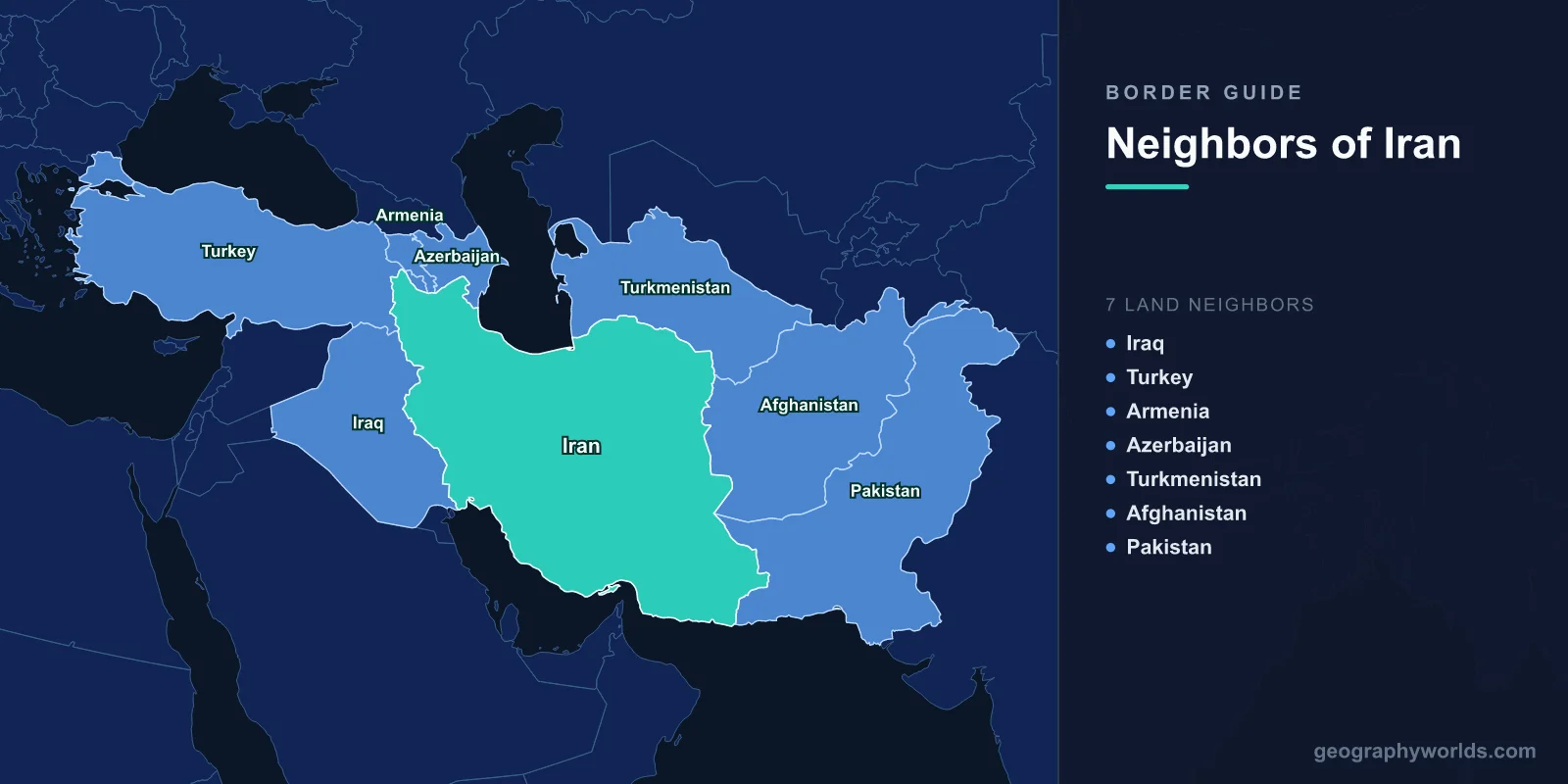
The Seven Land Neighbours at a Glance
- Iraq — approximately 1,600 km, the longest of Iran's borders, running the full length of the west.
- Turkmenistan — approximately 1,150 km along the northeast.
- Afghanistan — approximately 920 km along the east.
- Pakistan — approximately 900 km in the southeast.
- Azerbaijan — approximately 690 km in total, but split into two separate segments.
- Turkey — approximately 530 km in the far northwest.
- Armenia — approximately 40 km, one of the shortest international borders in Asia and by far Iran's shortest.
Figures vary between sources by a few dozen kilometres depending on survey method and how disputed segments are treated, so these should be read as close approximations rather than exact measurements.
The Western Frontier: Iraq and Turkey
Iran's border with Iraq is its longest and by a wide margin its most consequential. In the north it follows the crest of the Zagros Mountains, a range running some 1,600 kilometres northwest to southeast with peaks above 4,000 metres. That terrain made the boundary defensible and hard to cross, and it is why the frontier has been broadly stable in position for centuries even while sovereignty over it changed hands.
The southern end is different, and it is where the trouble has always been. There the border descends into the Mesopotamian lowlands and reaches the Shatt al-Arab — the waterway formed where the Tigris and Euphrates join before entering the Persian Gulf. Control of that channel matters because it is Iraq's only outlet to the sea and hosts Iran's port of Khorramshahr and refinery city of Abadan.
The 1975 Algiers Agreement set the boundary at the thalweg, the deepest channel of the waterway, replacing an earlier line that had run along the Iranian bank and effectively given Iraq the whole river. Iraq repudiated the agreement in 1980 and invaded, beginning the Iran-Iraq War, which lasted until 1988 and cost several hundred thousand lives on each side. Much of the fighting took place along this border, and the marshland and oil-bearing plains of Khuzestan were among the most heavily contested ground of the twentieth century. The thalweg line was subsequently reaffirmed.
The Turkish border, at around 530 kilometres, runs through high, cold country near Mount Ararat. It has been remarkably stable — the Treaty of Zuhab in 1639, between the Safavid and Ottoman empires, established a division of this region that later agreements largely refined rather than redrew, making it one of the oldest continuously recognised international boundaries in the world.
The Caucasus Edge and the Nakhchivan Puzzle
Northwest of Turkey, Iran meets Armenia and Azerbaijan along the Aras River, which forms much of the boundary. This section was fixed not by Iran's choice but by defeat: the Treaty of Gulistan in 1813 and the Treaty of Turkmenchay in 1828 ended two wars with the Russian Empire and transferred the territories of the South Caucasus — modern Armenia, Azerbaijan and Georgia — from Persian to Russian control. The Aras has marked the line ever since.
The Armenian border is only about 40 kilometres long, but its importance is out of all proportion to its length. Armenia's borders with Turkey and with Azerbaijan have been closed for decades, which leaves Iran and Georgia as its only functioning land routes to the outside world. The Aras crossing at Agarak-Nordooz is a genuine lifeline for the Armenian economy, and it explains a relationship that surprises people: Shia Iran maintains warm ties with Christian Armenia while being cooler toward Shia-majority Azerbaijan.
Azerbaijan's border comes in two pieces because of Nakhchivan, an Azerbaijani exclave separated from the rest of the country by Armenian territory. Iran borders the main body of Azerbaijan to the northeast of Armenia, and borders Nakhchivan to its southwest. The arrangement dates to the Treaty of Kars in 1921 and the Soviet administrative settlement that followed. Iran is the only country other than Armenia and Turkey that Nakhchivan touches, which gives Tehran real leverage over the exclave's access.
Turkmenistan and the Long Northeastern Line
The Turkmen border runs about 1,150 kilometres, second only to Iraq's. Its western end follows the Kopet Dag mountains, which rise steeply from the Iranian plateau, and its eastern end runs out into the fringes of the Karakum Desert. This was another Russian-imposed line, settled by an Anglo-Russian boundary commission in the 1880s as the Russian Empire absorbed Central Asia during the period of imperial competition with Britain.
Unlike the Iraqi frontier, this one has been quiet. There has been no war across it in the modern era, and the terrain — mountains giving way to desert with very few population centres on either side — offers little to fight over. The main crossings at Sarakhs, Bajgiran and Incheh Borun handle freight rather than armies, and Sarakhs sits on a rail link that forms part of the corridor between Central Asia and the Persian Gulf.
The relationship here is largely about gas and water. Turkmenistan holds some of the world's largest natural gas reserves, and pipelines cross into northern Iran to supply provinces that are far from Iran's own southern gas fields. The Dostluk dam on the Harirud is a joint project, and the border region contains Iran's ethnic Turkmen population, concentrated in Golestan and North Khorasan provinces.
Afghanistan, Pakistan and the Baluchistan Borderlands
Iran's eastern boundaries pass through some of the most arid and thinly governed territory in Asia. The Afghan border, roughly 920 kilometres, runs through desert and semi-desert, and its defining issue is water rather than land. The Helmand River rises in Afghanistan and drains into the Sistan wetlands on the Iranian side. A treaty signed in 1973 allocates Iran a share of the flow, but Afghan dam construction upstream and repeated drought have reduced deliveries, and the Hamun lakes that once supported fishing and farming in Sistan have dried out repeatedly. It is a recurring source of friction and has driven substantial migration out of the region.
The Pakistani border, roughly 900 kilometres, cuts through Baluchistan — a region whose Baloch population straddles the line, extending into Iran's Sistan and Baluchestan province and Pakistan's Balochistan. Neither section is easy to police. Both governments have built fencing and border posts, and the area sees persistent smuggling of fuel and narcotics along the route from Afghan opium production toward the Gulf and Europe. Iran maintains one of the largest counter-narcotics operations in the world along this frontier and has taken heavy casualties doing so.
Two Seas That Are Not Land Borders
Iran's maritime frontiers are as strategically significant as its land ones. To the north, roughly 740 kilometres of Caspian coastline face Russia, Kazakhstan, Turkmenistan and Azerbaijan. The Caspian's legal status was unresolved for decades after the Soviet collapse — whether it counts as a sea or a lake determines how its seabed resources are divided — and a 2018 convention at Aktau established a framework, though seabed delimitation involving Iran remains incomplete. Iran's share under most proposed formulas is the smallest of the five.
To the south, about 1,700 kilometres of coast face the Persian Gulf and the Gulf of Oman, putting Iran opposite Kuwait, Saudi Arabia, Bahrain, Qatar, the United Arab Emirates and Oman. The Strait of Hormuz, at its narrowest roughly 33 kilometres wide with shipping lanes only a few kilometres across, is the single most important oil chokepoint on Earth — a very large share of the world's seaborne crude passes through it. Iran controls the northern shore and the islands of Abu Musa and the Greater and Lesser Tunbs, whose sovereignty the United Arab Emirates disputes.
Seven Neighbours Against China's Fourteen and Brazil's Ten
Seven land neighbours places Iran well above average but short of the record. China and Russia lead the world with fourteen each. Brazil has ten, bordering every South American country except Chile and Ecuador. Germany has nine. Turkey has eight, and Pakistan has four.
What makes Iran's position unusual is not the count but the diversity of what it faces. Its seven neighbours include a NATO member, two post-Soviet republics locked in a long conflict with each other, two Central Asian states, and two of the least stable countries in Asia. It borders both the Caspian and the Persian Gulf, making it one of very few countries with coasts on two separate enclosed seas, and it sits directly on the land bridge between the Middle East, the Caucasus, Central Asia and South Asia.
That position has shaped Iranian history for three thousand years — every land route between the Mediterranean and India has crossed the Iranian plateau, and every empire in the region has had to reckon with it. The physical setting behind those borders, from the Zagros and Alborz ranges to the salt deserts of the interior, is covered in our guide to Iran's geography.