
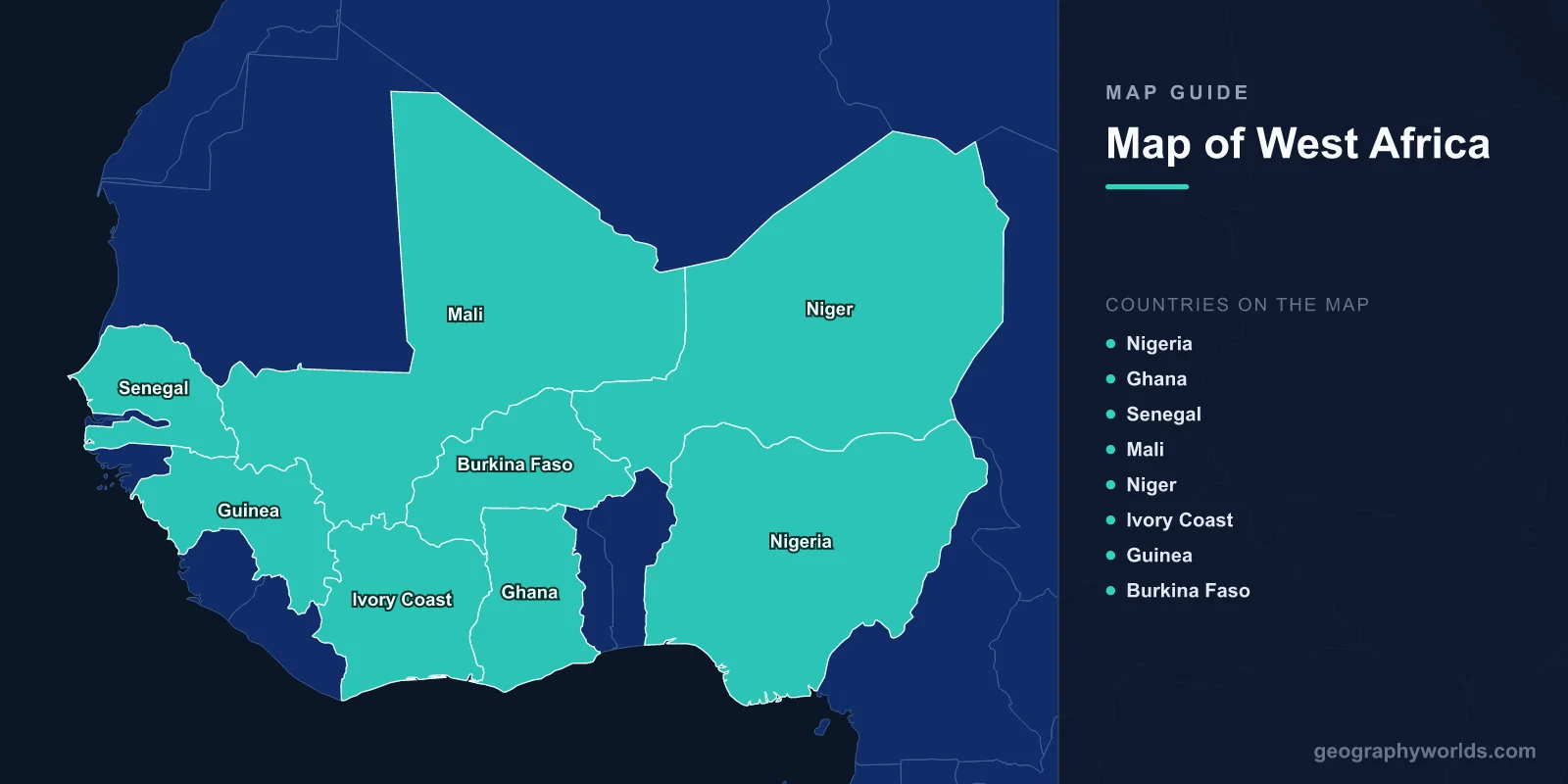
West Africa is a region of 16 countries covering roughly 6.14 million km² with a population of about 430 million — the most populous region of Africa. On a map it reads as a set of horizontal climate bands: Sahara desert in the north, the semi-arid Sahel below it, savanna in the middle, and tropical rainforest along the Gulf of Guinea coast. Nearly every border in the region cuts across those bands rather than following them.

The single most useful thing to understand about a map of West Africa is that it is organised by latitude, not longitude. Rainfall increases steadily as you move south from the Sahara toward the coast, and vegetation, farming systems, disease environments, historical states and even religious geography follow that gradient. Read the region as a set of east–west stripes and the map starts making sense.
The Region at a Glance
- Area: about 6.14 million km² (2.37 million sq mi)
- Population: approximately 430 million, and growing faster than any comparable region on Earth
- Countries: 16 sovereign states
- Coastline: roughly 4,000 km, from Mauritania around to the eastern Gulf of Guinea
- Highest point: Mount Bintumani in Sierra Leone, about 1,948 m, is the highest summit in West Africa proper
- Major river: the Niger, about 4,180 km — the third-longest in Africa
- Climate zones: Saharan, Sahelian, Sudanian, Guinean
The 16 countries are Benin, Burkina Faso, Cabo Verde, Côte d'Ivoire, The Gambia, Ghana, Guinea, Guinea-Bissau, Liberia, Mali, Mauritania, Niger, Nigeria, Senegal, Sierra Leone and Togo. Nigeria alone accounts for over half the region's population and a comparable share of its economic output. Most of these states belong to ECOWAS, the Economic Community of West African States, and eight of them share the CFA franc — a currency pegged first to the French franc and now to the euro. Our ECOWAS guide covers the bloc in detail, and a full country-by-country breakdown is in our list of West African countries.
Terrain: Mostly Flat, With Three Exceptions
West Africa is unusually low-lying for a region of its size. There is no equivalent of the East African Rift, no Atlas range, no high plateau spanning the interior. Most of the region sits below 500 m on a stable ancient basement of Precambrian rock, overlain by sedimentary basins.
Three upland areas break the pattern, and all three matter out of proportion to their size:
- The Fouta Djallon in Guinea, rising to around 1,500 m. It is called the water tower of West Africa for good reason: the Niger, the Senegal and the Gambia rivers all rise here.
- The Guinea Highlands, straddling Guinea, Sierra Leone, Liberia and Côte d'Ivoire, containing Mount Bintumani and Mount Nimba, and holding some of the region's last significant rainforest.
- The Jos Plateau in central Nigeria, at roughly 1,200–1,400 m. Its elevation gives it a temperate climate in the tropics, historically making it both a tin-mining centre and a refuge zone with distinctive local cultures.
The coast itself is a distinctive landform: long stretches of sandbar and lagoon, particularly from Côte d'Ivoire through Ghana, Togo, Benin and into Nigeria, backed by mangrove where rivers reach the sea. These lagoons made coastal navigation difficult for European ships but supported dense local populations — Lagos, Cotonou and Abidjan all grew on lagoon sites.
The Niger River and the Region's Water
The Niger does something no other major river does: it flows away from the sea before turning back toward it. Rising in the Fouta Djallon barely 250 km from the Atlantic, it runs northeast into the Sahara, arcs east through Mali past Timbuktu, then turns southeast through Niger and Nigeria to reach the Gulf of Guinea — a journey of about 4,180 km to cover a straight-line distance of a few hundred kilometres.
Two features of that course dominate West African hydrology:
- The Inner Niger Delta in Mali, a seasonal floodplain that can expand to something like 20,000 km² at high water. It supports one of Africa's most productive inland fisheries and a system of flood-recession farming and pastoralism that has been in place for a thousand years.
- The Niger Delta on the coast, roughly 36,000 km² — among the world's largest river deltas, densely populated, ecologically rich, and the centre of Nigeria's petroleum industry, with all the pollution and conflict that has brought.
Other significant water bodies include the Senegal River, which forms the Senegal–Mauritania border; Lake Volta in Ghana, at about 8,502 km² the world's largest artificial lake by surface area, created behind the Akosombo Dam in the 1960s; and the Gulf of Guinea, whose fisheries and offshore oil and gas make it one of Africa's most strategically important marine zones.
Then there is Lake Chad, on the region's eastern margin, which has become the standard illustration of environmental change in the Sahel. It covered something like 25,000 km² in the early 1960s and has shrunk by well over 90% since, driven by a combination of reduced rainfall, upstream irrigation withdrawal and population pressure. The consequences — collapsed fisheries, lost grazing, displaced communities — feed directly into the region's security problems. See our guide to Lake Chad for the full picture.
Climate: Four Bands, One Monsoon
West Africa's climate is governed by the West African Monsoon, which draws moist air north off the Gulf of Guinea during the northern summer. How far north that moisture penetrates, and for how long, determines everything.
- Saharan (northern Mauritania, Mali, Niger): hyper-arid, under 100 mm of rain a year, and in places effectively none.
- Sahelian: roughly 200–600 mm, falling in a single short wet season. Grazing land and drought-tolerant crops such as millet and sorghum.
- Sudanian savanna: roughly 600–1,200 mm, supporting grassland with scattered woodland, and a wider range of crops.
- Guinean forest: over 1,600 mm along the coast, with a genuine two-season rainfall pattern in places and tropical forest as the natural vegetation.
The Sahel is among the most climate-vulnerable places on Earth, not because it is dry but because its rainfall is so variable year to year. A 20% shortfall is the difference between an adequate harvest and a failed one for millions of subsistence farmers. The severe droughts of the 1970s and 1980s reshaped settlement across the belt, and desertification continues to push southward in places. The Great Green Wall initiative — an African Union project aiming to restore degraded land across the width of the continent — is the region's most ambitious response, though its progress has been uneven. Our Sahel geography guide goes deeper.
West Africa vs East Africa: Why the Maps Look So Different
Comparing West Africa with East Africa isolates how much tectonics shapes a region's human geography.
- Relief: East Africa is dominated by the Great Rift Valley, high plateaus and volcanoes exceeding 5,000 m, including Kilimanjaro and Mount Kenya. West Africa is essentially flat, topping out below 2,000 m. East Africa sits on an active continental rift; West Africa on a stable craton.
- Altitude and climate: East Africa's elevation gives it temperate highland climates on the Equator — which is why Nairobi and Addis Ababa are cool cities at tropical latitudes. West Africa has no equivalent apart from small areas like the Jos Plateau, so its climate is set almost purely by latitude.
- Lakes: East Africa's rift holds some of the world's deepest lakes — Tanganyika and Malawi. West Africa's largest lakes are shallow (Chad) or artificial (Volta).
- Rivers: the Niger is a single dominant system draining west to the Atlantic. East Africa feeds the Nile and the Congo, with watersheds far from their outlets.
- Coastal orientation: West Africa faces the Atlantic and was drawn into the Atlantic trade system — with all its consequences. East Africa faces the Indian Ocean and was integrated into monsoon trade with Arabia, India and China for well over a thousand years.
People, Economy and the Legacy of Straight Lines
West Africa's population geography reflects the climate bands directly. The dense clusters are on the coast — Lagos, Abidjan, Accra, Dakar — and in the well-watered savanna belt, particularly northern Nigeria around Kano. The Saharan north is nearly empty.
Look closely at the borders and you will notice how many are straight lines running north–south. That is a colonial artefact, and it has a specific geographic consequence: most West African states contain a slice of several climate zones, so a single country may hold desert pastoralists, savanna farmers and coastal fishing communities. Nigeria, Ghana, Côte d'Ivoire, Togo and Benin all stretch from coast to interior. This gives these states internal economic diversity but also a recurring north–south political fault line, since the different bands support very different livelihoods.
Economically the region is defined by primary commodities: cocoa from Côte d'Ivoire and Ghana, which between them produce roughly 60% of the world's supply; oil and gas from Nigeria and increasingly Ghana and Senegal; bauxite from Guinea, which holds among the world's largest reserves; gold from Mali, Ghana and Burkina Faso; and cotton across the Sahel. Historically, the same geography carried the trans-Saharan trade — gold and salt moving between the Sahel and North Africa — which built Timbuktu into one of the great learning centres of the 15th and 16th centuries, with libraries holding hundreds of thousands of manuscripts.
West Africa is also the youngest region on the planet by median age, with population growth rates that will make it central to global demographics this century. Reading its map — the bands, the Niger's improbable arc, the straight-line borders cutting across both — is a good starting point for understanding why.