

An aquifer is an underground layer of permeable rock, sediment, or soil that holds and transmits groundwater. The world's largest aquifer is the Great Artesian Basin in Australia, covering 1.7 million km². Aquifers supply drinking water to roughly 2 billion people worldwide and provide about 30% of the world's freshwater supply.
Introduction
Beneath our feet lies a vast, hidden world of water. Aquifers are the planet's underground reservoirs, storing water in the tiny spaces between grains of sand, gravel, and rock, or in the cracks and fissures of limestone and other permeable formations. Some aquifers hold water that fell as rain thousands of years ago, while others are continuously replenished by modern precipitation.
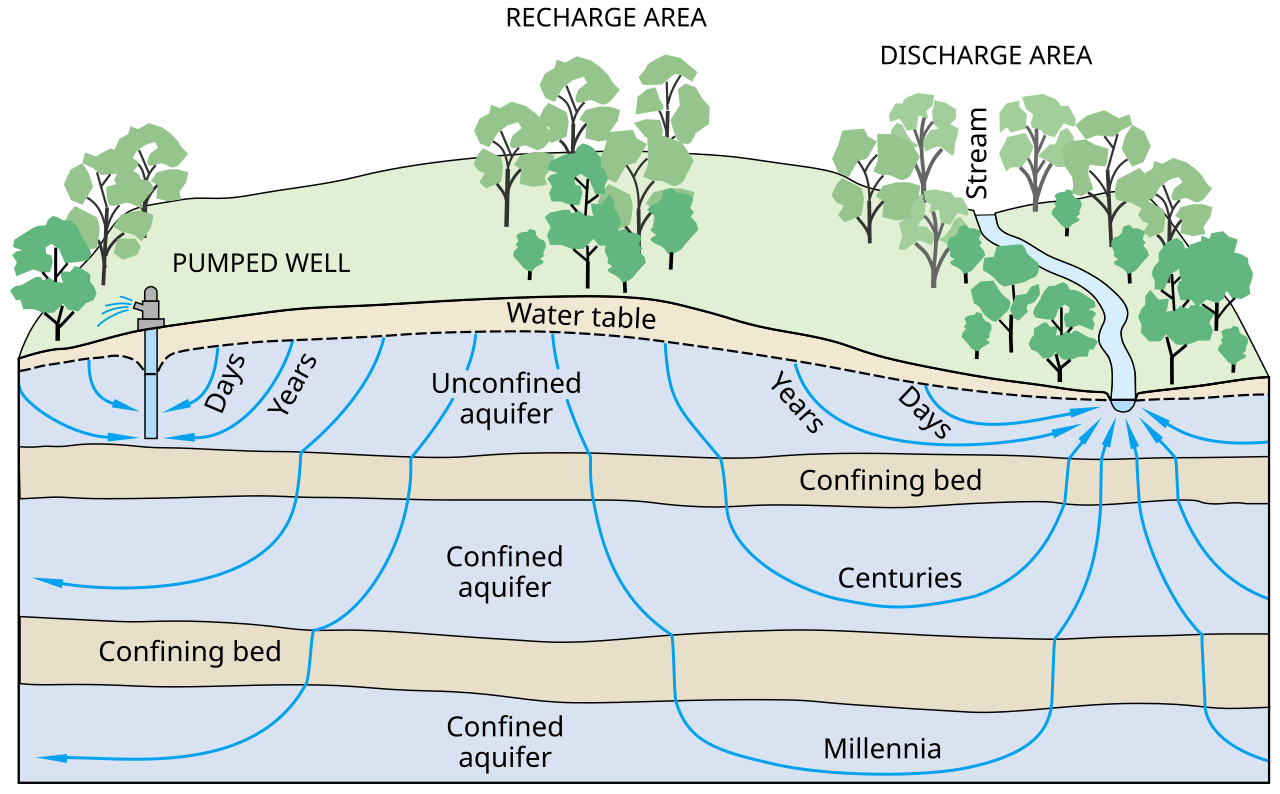
How Aquifers Work
- Porosity: The percentage of rock volume that is open space (pores) where water can be stored
- Permeability: How easily water can flow through the material — determines if it's an aquifer or not
- Water Table: The upper surface of the saturated zone in an unconfined aquifer
- Recharge: The process by which rainwater infiltrates the ground and replenishes the aquifer
- Discharge: Where groundwater exits through springs, wells, or seepage into rivers/lakes
An aquifer forms when underground rock or sediment has both high porosity (lots of space to hold water) and high permeability (the spaces are connected so water can flow through). Sand and gravel make excellent aquifers because they have both qualities. Clay has high porosity but very low permeability — it holds water but won't release it — so it acts as an aquitard, blocking water flow.
Water enters aquifers through recharge zones, where permeable rock is exposed at the surface and precipitation can infiltrate downward. The speed of groundwater movement varies enormously — from meters per day in gravel to centimeters per year in fine sand. This slow movement means aquifer pollution can take decades to remediate.
Types of Aquifers
- Unconfined Aquifer: Top is the water table; directly connected to the surface; easily recharged but vulnerable to contamination
- Confined Aquifer: Sandwiched between impermeable layers (aquitards); under pressure; artesian conditions possible
- Artesian Aquifer: A confined aquifer where water pressure is high enough to push water up without pumping
- Perched Aquifer: Small aquifer sitting above the main water table, held up by an impermeable layer
- Karst Aquifer: Formed in dissolved limestone with caves and underground rivers; fast-flowing but vulnerable
Unconfined aquifers are the most common type and are directly connected to the surface through the unsaturated zone above. The water table in these aquifers rises and falls with seasonal rainfall and pumping. Because they are connected to the surface, they are vulnerable to contamination from agricultural chemicals, industrial waste, and sewage.
Confined aquifers are trapped between impermeable layers and are often under significant pressure. When a well is drilled into a confined aquifer, water may rise above the top of the aquifer — and in artesian conditions, it can flow to the surface without any pumping. The Great Artesian Basin in Australia is the world's largest artesian aquifer, and when it was first drilled in 1878, water gushed 30 meters into the air.
World's Largest Aquifers
- Great Artesian Basin (Australia): 1.7 million km² — world's largest; some water is 2 million years old
- Ogallala Aquifer (USA): 450,000 km² — underlies 8 Great Plains states; rapidly depleting
- Guarani Aquifer (South America): 1.2 million km² — beneath Brazil, Argentina, Paraguay, Uruguay
- Nubian Sandstone Aquifer (Africa): 2 million km² — beneath Libya, Egypt, Sudan, Chad; mostly non-renewable
- North China Plain Aquifer: Supplies water to 200 million people; critically over-pumped
The Ogallala Aquifer is perhaps the most important — and most threatened — aquifer in the world. It underlies the Great Plains of the United States from South Dakota to Texas and irrigates about 30% of all US farmland. However, it is being pumped at rates far exceeding natural recharge, and in some areas the water table has dropped by more than 30 meters since the 1950s.
The Nubian Sandstone Aquifer System in North Africa contains an estimated 150,000 km³ of fossil water deposited during wet periods thousands of years ago. Libya's Great Man-Made River project pumps from this aquifer to supply coastal cities, but the water is essentially non-renewable — it would take thousands of years to recharge naturally.
Aquifer Depletion & Threats
- Over-pumping: Extracting water faster than natural recharge — the biggest global threat
- Land Subsidence: Ground sinks as aquifers are emptied; Mexico City has sunk 10+ meters
- Saltwater Intrusion: Over-pumping coastal aquifers allows seawater to infiltrate
- Contamination: Agricultural chemicals, industrial waste, and PFAS pollute groundwater
- Climate Change: Altered precipitation patterns affect recharge rates
Aquifer depletion is one of the most serious environmental challenges of the 21st century. NASA's GRACE satellite mission has revealed that 21 of the world's 37 largest aquifers are being depleted faster than they are being recharged. The most stressed include the Arabian Aquifer System, the Indus Basin aquifer in India and Pakistan, and the Murzuk-Djado Basin in North Africa.
Mexico City provides a dramatic example of the consequences of aquifer depletion. Built on a former lakebed, the city has pumped groundwater so aggressively that it has sunk more than 10 meters in the past century, and continues to subside at a rate of about 50 centimeters per year. This causes buildings to tilt, pipes to crack, and flooding to worsen.
Key Facts
- An aquifer is an underground layer of permeable rock that holds and transmits groundwater.
- Aquifers supply drinking water to roughly 2 billion people worldwide.
- About 30% of the world's freshwater is stored in underground aquifers.
- The Great Artesian Basin in Australia is the world's largest aquifer at 1.7 million km².
- 21 of the world's 37 largest aquifers are being depleted faster than they can recharge.
Fun Facts
- Some water in the Great Artesian Basin fell as rain over 2 million years ago — making it older than the human species.
- The word "aquifer" comes from Latin: "aqua" (water) + "ferre" (to bear/carry).
- If all the groundwater on Earth came to the surface, it would cover the entire planet to a depth of about 180 meters.
- The world's deepest known aquifer is about 3 km below the surface in South Africa, containing water that has been isolated for millions of years.
Final Thoughts
Aquifers are invisible but indispensable — they store and supply the groundwater that billions of people depend on for drinking, agriculture, and industry. As global demand for water grows and climate change alters precipitation patterns, understanding and sustainably managing aquifers is one of the most critical geographic challenges of our time.
Test Your Knowledge!
Think you know your geography? Try our interactive quiz!
Play Geography Games →