
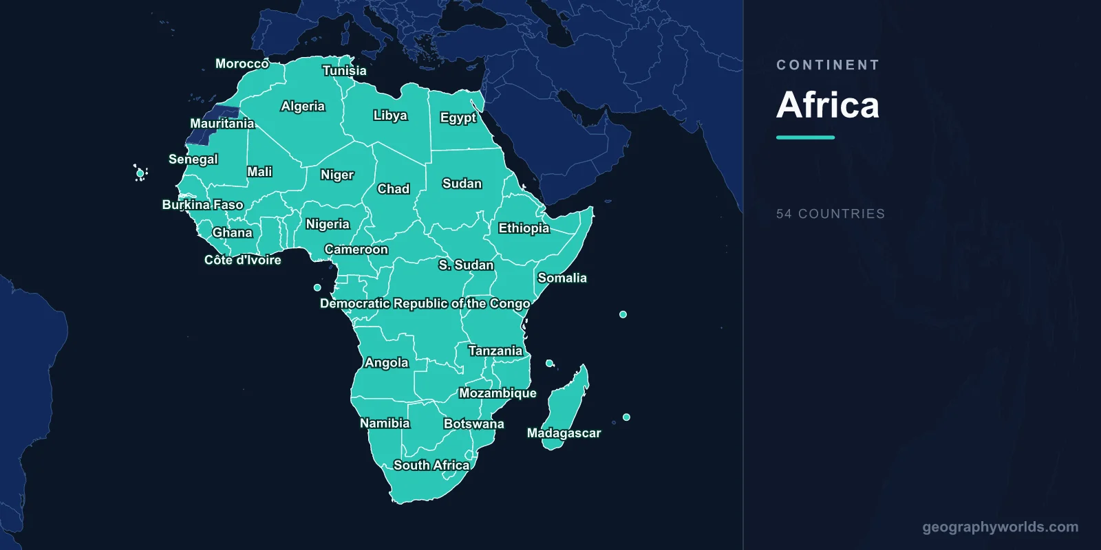
Africa has 54 internationally recognised countries spread across about 30.37 million km², roughly a fifth of Earth's land. On a map they fall into six groups: six North African states along the Mediterranean and the Sahara, sixteen in West Africa, eight in Central Africa, ten in East Africa and the Horn, ten in Southern Africa, and four island nations in the Indian Ocean. The largest is Algeria at 2.38 million km², the smallest on the mainland is The Gambia, and the newest is South Sudan, independent since July 2011.
How to read Africa's political map
The quickest way to orient yourself is with three lines. The equator crosses seven countries: Gabon, the Republic of the Congo, the Democratic Republic of the Congo, Uganda, Kenya, Somalia and, by a few hundred metres on the islet of Rolas, São Tomé and Príncipe. The prime meridian runs south from Algeria through Mali, Burkina Faso, Togo and Ghana. And the Sahara, about 9.2 million km² of desert, sweeps across ten countries plus Western Sahara, splitting the continent into a thinly populated north and the far more crowded lands south of it.
Count carefully and you will meet two numbers. The United Nations has 54 African members. The African Union has 55, because it also seats the Sahrawi Arab Democratic Republic, which claims Western Sahara, a territory Morocco controls for the most part. Somaliland, in the north of Somalia, has governed itself since 1991 but is recognised by no UN member. Neither is counted in the 54. If you want the full reasoning behind the figure, our guide to how many countries are in Africa walks through each disputed case.
North Africa: six states on the Sahara's rim
North Africa is the band where the Mediterranean meets the desert. Morocco (capital Rabat) faces both the Atlantic and Mediterranean, with the Atlas Mountains running behind its coast. Algeria (Algiers) is the continent's largest country, more than four-fifths of it Saharan. Tunisia (Tunis) is the smallest of the group. Libya (Tripoli) has a 1,770-kilometre coastline and almost no permanent rivers. Egypt (Cairo) packs most of its population into the narrow Nile valley and delta, about 5% of its territory. Sudan (Khartoum) is where the Blue and White Nile meet; since war broke out in 2023 its government has worked largely from Port Sudan on the Red Sea.
Egypt also gives Africa a foothold in Asia. The Sinai Peninsula, east of the Suez Canal, makes it one of the few transcontinental countries on the map.
West Africa: sixteen countries from Dakar to Abuja
West Africa is the most crowded region on the map, both in countries and in people. Along the Atlantic bulge from north to south sit Mauritania (Nouakchott), Senegal (Dakar, on the continent's westernmost point), The Gambia (Banjul), Guinea-Bissau (Bissau), Guinea (Conakry), Sierra Leone (Freetown) and Liberia (Monrovia). Out in the ocean, 570 kilometres off Senegal, lies the archipelago of Cabo Verde (Praia).
The Gulf of Guinea coast continues with Côte d'Ivoire, whose official capital is Yamoussoukro although Abidjan is far larger, then Ghana (Accra), Togo (Lomé), Benin (Porto-Novo, with the government largely in Cotonou) and Nigeria, whose capital moved from Lagos to the planned city of Abuja in 1991. Nigeria alone holds over 220 million people, more than any other African country.
Inland lie three large Sahel states: Mali (Bamako), Burkina Faso (Ouagadougou) and Niger (Niamey). All three are landlocked and depend on the Niger River, which rises in Guinea's highlands, arcs north-east past Timbuktu and swings south through Niger and Nigeria to its delta. Two curiosities stand out on any map here: The Gambia is a ribbon of land about 10 to 50 kilometres wide along its river, surrounded on three sides by Senegal, and Benin and Togo are so narrow that a drive across either takes only a few hours. For the regional groupings and the 2025 split in ECOWAS, see our list of West African countries.
Central Africa and the Congo Basin
Central Africa is built around the Congo River and its rainforest, the second largest on Earth. The Democratic Republic of the Congo (Kinshasa) dominates it at 2.34 million km², second only to Algeria in Africa, with just 37 kilometres of Atlantic coast at the river's mouth. Across the river sits the much smaller Republic of the Congo, whose capital Brazzaville faces Kinshasa, the closest pair of national capitals in the world apart from Rome and Vatican City.
To the north are Cameroon (Yaoundé), the Central African Republic (Bangui) and, reaching deep into the Sahara, Chad (N'Djamena), which takes its name from a lake that has shrunk by about 90% since the 1960s. On the Atlantic coast are Gabon (Libreville) and Equatorial Guinea. Its capital, Malabo, is on Bioko Island, and a new capital, Ciudad de la Paz, is being built on the mainland. In the Gulf of Guinea lies São Tomé and Príncipe (São Tomé), the second-smallest African country by area.
East Africa, the Horn and the Rift Valley
East Africa is shaped by the Great Rift Valley, which runs from the Red Sea to Mozambique and holds most of the continent's great lakes and highest mountains. The Horn of Africa, the point projecting into the Indian Ocean, contains four countries: Ethiopia (Addis Ababa), landlocked since Eritrea's independence; Eritrea (Asmara), independent since 1993; Djibouti (Djibouti), which guards the Bab-el-Mandeb strait; and Somalia (Mogadishu), with the longest coastline on the mainland. Our page on where the Horn of Africa is covers that corner in detail.
Further south are Kenya (Nairobi), Uganda (Kampala) and Tanzania, which has moved its capital from Dar es Salaam to Dodoma and includes the island of Zanzibar. The three share Lake Victoria, at about 68,870 km² the largest lake in Africa. Mount Kilimanjaro, 5,895 metres, rises in Tanzania near the Kenyan border. Two small, densely populated highland states, Rwanda (Kigali) and Burundi, whose political capital moved from Bujumbura to Gitega in 2019, sit between the lakes. South Sudan (Juba), carved out of Sudan in 2011, completes the region.
Southern Africa below the Zambezi
Southern Africa's ten countries are anchored by South Africa, the only country with three capitals: Pretoria (executive), Cape Town (legislative) and Bloemfontein (judicial). Two kingdoms lie inside or against it. Lesotho (Maseru) is completely surrounded by South Africa and is the only country entirely above 1,000 metres. Eswatini, with its administrative capital at Mbabane and its royal and legislative seat at Lobamba, lies almost entirely within South Africa too.

On the Atlantic side are Angola (Luanda) and Namibia (Windhoek), whose coastal Namib is among the oldest deserts on Earth. Inland are Botswana (Gaborone), home to the Okavango Delta, a river that fans out and evaporates in the Kalahari instead of reaching the sea, as well as Zambia (Lusaka), Zimbabwe (Harare) and Malawi (Lilongwe), which is wrapped around the western shore of Lake Malawi. On the Indian Ocean, Mozambique (Maputo) has about 2,500 kilometres of coastline. The Zambezi links much of the region, forming the Zambia–Zimbabwe border and pouring over Victoria Falls on its way to Mozambique. For how definitions of the region vary, see our guide to what counts as Southern Africa.
Four island states in the Indian Ocean
Madagascar (Antananarivo) is the fourth-largest island in the world at about 587,000 km². It split from the African mainland roughly 88 million years ago, which is why most of its wildlife, from lemurs to baobabs, lives nowhere else. To the east are Mauritius (Port Louis) and, further north, the 115 islands of Seychelles (Victoria), the smallest African country by both area and population. Between Madagascar and Mozambique lie the volcanic islands of Comoros (Moroni). A fifth Comorian island, Mayotte, voted to remain French and is now an overseas department of France.
Sixteen countries without a coast
One more pattern stands out on the map: sixteen African countries have no coastline, more than on any other continent. They are Botswana, Burkina Faso, Burundi, the Central African Republic, Chad, Eswatini, Ethiopia, Lesotho, Malawi, Mali, Niger, Rwanda, South Sudan, Uganda, Zambia and Zimbabwe. Most of their trade travels hundreds or thousands of kilometres by road or rail to someone else's port: Ethiopia's runs mainly through Djibouti, Uganda's and Rwanda's through Mombasa in Kenya and Dar es Salaam in Tanzania, and Zambia's copper through Dar es Salaam on the TAZARA railway, built in the 1970s, or south to Durban. Chad is the most remote of all, its capital about 1,000 kilometres from the nearest sea.
Borders drawn in Berlin
Many of the straight lines on Africa's map date from the Berlin Conference of 1884–85 and the treaties that followed it, when European powers divided the continent among themselves with little regard for the peoples living there. That is why Libya's and Egypt's southern borders follow lines of latitude and longitude, and why ethnic groups such as the Maasai, split between Kenya and Tanzania, or the Ewe, split between Ghana and Togo, live on both sides of a border.
When most of these colonies became independent between 1956 and 1975, the Organisation of African Unity agreed in 1964 to keep the inherited borders rather than redraw them, fearing endless wars. The map has changed only twice since: Eritrea separated from Ethiopia in 1993, and South Sudan from Sudan in 2011. A few gaps remain unresolved, chiefly Western Sahara, still on the UN's list of non-self-governing territories, and Somaliland. Those decisions explain why Africa today has more countries than any other continent, and why the 54 you can trace on a map are, with those two exceptions, the same shapes that appeared on the colonial maps of the early twentieth century.