

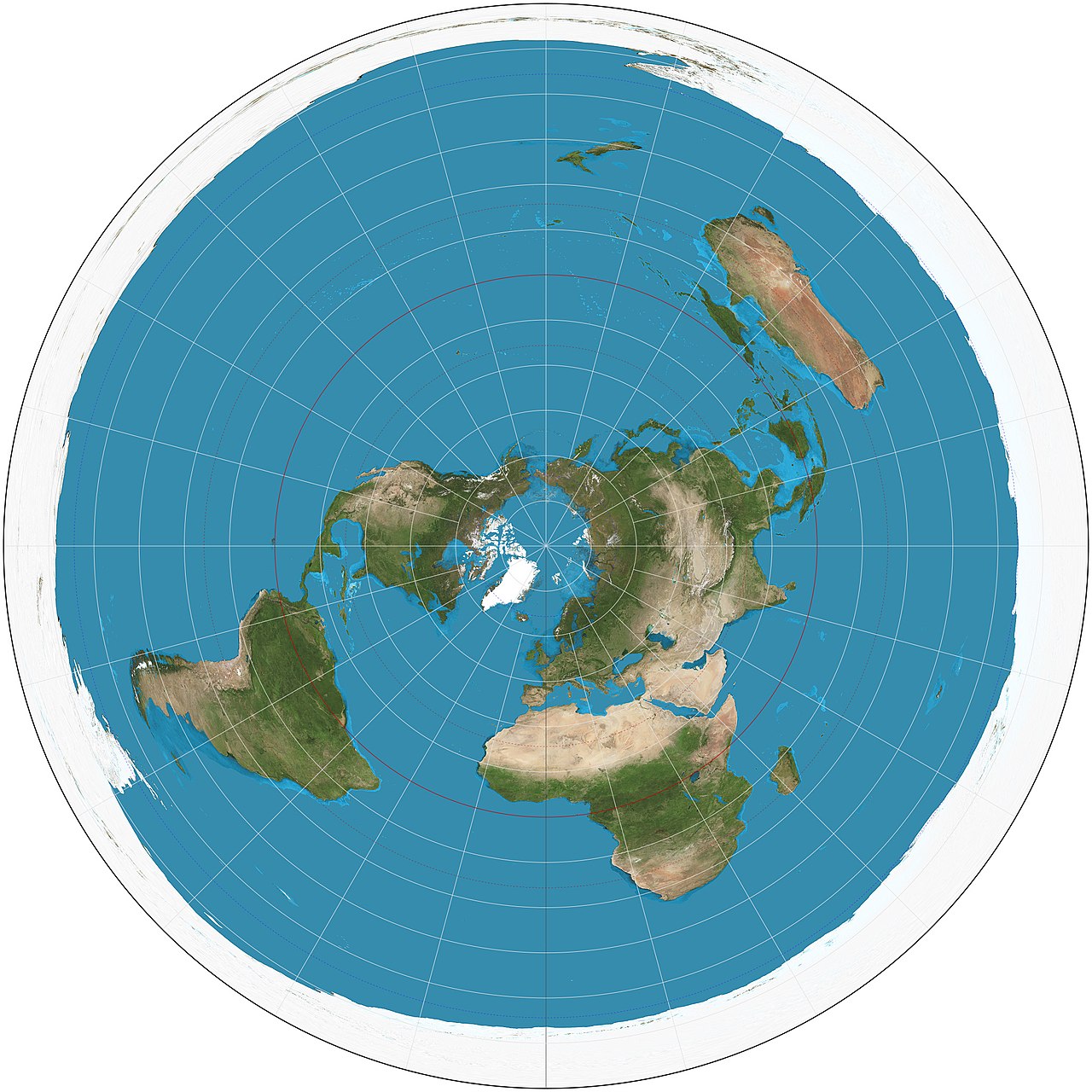
The azimuthal equidistant projection is a map that shows correct distances and directions from a single central point to every other point on Earth. Centered on the North Pole, this projection famously appears on the flag and emblem of the United Nations, symbolizing a global perspective that favors no single nation.
Introduction
This projection has practical applications beyond symbolism. It is used by radio operators to determine the shortest transmission path, by seismologists to locate earthquake epicenters, and by airlines to plan great circle routes. Any point can serve as the center, making it infinitely customizable.
How It Works
- Type: Azimuthal (planar) projection
- Key Property: True distance from center point
- Directions: True from center point only
The azimuthal equidistant projection places a flat plane tangent to the globe at a chosen center point. All points on the globe are projected onto this plane such that the distance from the center to any other point on the map equals the true great circle distance on the globe, scaled proportionally.
Directions from the center point are also correct: if a city lies due northeast of the center on the globe, it will appear due northeast on the map. However, distances and directions between any two points that are not the center point are generally distorted.
The UN Flag
- Adopted: 1946
- Center Point: North Pole
- Extent: Shows to 60°S latitude
- Symbolism: No country is at the center or edge
The United Nations adopted the azimuthal equidistant projection centered on the North Pole for its emblem in 1946. The map extends to 60 degrees south latitude, which includes all inhabited continents. Antarctica is excluded to prevent any country from appearing at the periphery of the map.
The choice was deliberate: by centering on the North Pole rather than any nation, the map avoids placing any country in a position of visual prominence. The olive branches surrounding the map symbolize peace. This design has remained unchanged since the UN's founding.
Distortion Pattern
- At Center: Zero distortion
- At Edges: Increasing area and shape distortion
- Opposite Side: Extreme stretching (entire hemisphere becomes a ring)
Distortion on an azimuthal equidistant projection increases with distance from the center point. Near the center, the map is nearly perfect in all properties. At the antipode (the point on the exact opposite side of the globe), the distortion becomes infinite as a single point is stretched into the entire outer edge of the map.
If centered on the North Pole, Antarctica stretches into a ring around the entire outer edge. If centered on a city, the antipodal region on the other side of the Earth appears as a severely distorted border. This makes the projection useful only for showing distances from a specific location.
Practical Applications
- Ham Radio: Determining antenna direction
- Seismology: Locating earthquake epicenters
- Aviation: Great circle route planning
Amateur radio operators frequently create personal azimuthal equidistant maps centered on their location. These maps allow them to instantly determine the correct antenna direction and distance to any other station in the world, which is essential for directional high-frequency radio communication.
Seismologists use azimuthal equidistant maps centered on seismic stations to quickly determine the distance and direction to earthquake epicenters from the arrival times of seismic waves. Airlines use them to visualize great circle routes, which appear as straight lines radiating from the center.
Variations and Limits
- Polar Aspect: Centered on North or South Pole
- Oblique Aspect: Centered on any point
- Hemisphere Limit: Most useful within a hemisphere
The polar aspect, centered on the North or South Pole, produces a map where all meridians radiate outward as straight lines and parallels appear as concentric circles. This version is commonly used in polar research, aviation charts for transpolar flights, and the UN emblem.
The oblique aspect, centered on any chosen point, is used for specialized applications. A map centered on New York shows the true distance from New York to every city in the world. Some flat Earth proponents mistakenly use this projection to support their beliefs, not realizing it is a deliberate distortion of a sphere.
Key Facts
- The azimuthal equidistant projection shows true distances from the center to every other point.
- The United Nations flag uses this projection centered on the North Pole.
- Distances and directions are only accurate from the center point, not between other points.
- The projection has been used since at least the 11th century by Islamic cartographers.
- The antipodal point (opposite side of Earth) stretches into the entire outer edge of the map.
Fun Facts
- Some flat Earth conspiracy theorists use the azimuthal equidistant projection as their "true map," not realizing it is a standard projection of a sphere.
- The UN map extends to only 60 degrees south to avoid showing Antarctica stretched around the edge.
- Ham radio operators are among the most frequent users of custom azimuthal equidistant maps.
- The projection can theoretically show the entire globe, but the far side becomes infinitely distorted.
Final Thoughts
The azimuthal equidistant projection is a powerful specialized tool that shines when you need to know the true distance and direction from a specific point. Its appearance on the United Nations flag makes it one of the most symbolically significant projections in cartographic history, representing a world seen from above with no single nation at its center.
Test Your Knowledge!
Think you know your map projections? Try our interactive quiz!
Play Geography Games →