

Borders do not stop at the shoreline. The world's oceans are divided into a complex system of maritime zones that extend national sovereignty, economic rights, and legal jurisdiction far out to sea. From the 12-nautical-mile territorial waters to the 200-nautical-mile exclusive economic zone and beyond, the ocean is carved into invisible boundaries that govern fishing, mining, navigation, and military operations.
Introduction
Maritime borders are governed primarily by the United Nations Convention on the Law of the Sea (UNCLOS), often called the "constitution of the oceans." Adopted in 1982, UNCLOS created the framework that determines who can fish where, who owns underwater resources, and where naval vessels can operate freely. Yet the ocean's borders remain some of the most fiercely disputed on Earth, from the South China Sea to the Eastern Mediterranean.
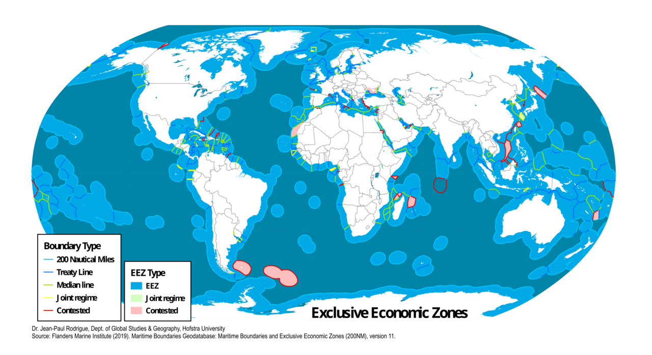
Maritime Zones Explained
- Territorial Sea: 12 nautical miles — full sovereignty
- Contiguous Zone: 24 nautical miles — limited enforcement rights
- Exclusive Economic Zone: 200 nautical miles — resource rights
- Continental Shelf: Can extend beyond EEZ if geological conditions are met
- High Seas: Beyond all national claims — open to all
UNCLOS defines concentric zones radiating outward from a nation's coastline. The territorial sea extends 12 nautical miles (22.2 km) from the baseline, where the coastal state exercises full sovereignty — the same legal authority it has over its land territory. Foreign vessels have a right of "innocent passage" through territorial seas, meaning they can transit without stopping, but submarines must surface and warships must not engage in threatening activities.
The Exclusive Economic Zone (EEZ) extends 200 nautical miles (370.4 km) from the coastline, giving the coastal state sovereign rights over all natural resources — fish, oil, gas, minerals, and renewable energy. Other nations retain freedom of navigation and overflight in the EEZ. Beyond the EEZ, the continental shelf may extend further if the coastal state can prove the seabed is a natural geological extension of its landmass. The high seas beyond all national claims are governed by international law and are open to all nations.
The South China Sea: The World's Most Disputed Water
- Claimants: China, Vietnam, Philippines, Malaysia, Brunei, Taiwan
- China's Claim: Nine-dash line covering ~90% of the sea
- 2016 Ruling: Permanent Court of Arbitration ruled against China
- Resources: Estimated 11 billion barrels of oil, major fishing grounds
The South China Sea is the most contested maritime space on Earth. China claims approximately 90% of the 3.5-million-square-kilometer sea based on a vaguely defined "nine-dash line" that overlaps with the EEZ claims of Vietnam, the Philippines, Malaysia, Brunei, and Taiwan. China has reinforced its claims by building artificial islands on reefs and atolls, creating military installations complete with airstrips, radar systems, and missile batteries.
In 2016, the Permanent Court of Arbitration in The Hague ruled that China's nine-dash line has no legal basis under UNCLOS and that China had violated the Philippines' sovereign rights by interfering with fishing and petroleum exploration in the Philippine EEZ. China rejected the ruling entirely, calling it "null and void." The dispute remains unresolved, with regular confrontations between Chinese coast guard vessels and the fishing and naval vessels of neighboring countries.
Island Disputes: Tiny Rocks, Vast Ocean Claims
- Key Principle: Islands generate EEZ claims; rocks do not (UNCLOS Article 121)
- Senkaku/Diaoyu: Disputed between Japan, China, and Taiwan
- Spratly Islands: Claimed wholly or partly by 6 nations
- Rockall: UK-claimed rock in the North Atlantic, disputed by Ireland and Iceland
Under UNCLOS, a habitable island generates a full 200-nautical-mile EEZ, while a "rock which cannot sustain human habitation" generates only a 12-nautical-mile territorial sea. This distinction makes the classification of tiny islands and rocks one of the most consequential legal questions in maritime law. A single rock reclassified as an island can claim over 430,000 square kilometers of ocean.
Japan maintains a concrete encasement around Okinotorishima, a tiny coral atoll that barely rises above water, arguing it is an island that generates a Japanese EEZ larger than Japan's entire land area. China and South Korea dispute this classification. Similarly, the Philippines and China clash over Scarborough Shoal, a partially submerged reef that China has effectively controlled since 2012. These seemingly trivial geographic features are proxies for vast oceanic resource claims.
EEZ Overlaps and Negotiations
- Global Overlaps: Hundreds of overlapping EEZ claims exist worldwide
- Resolution Methods: Negotiation, median line principle, ICJ rulings
- Example: Norway-Russia Barents Sea agreement took 40 years (1970–2010)
- Example: Australia-Timor-Leste resolved in 2018 after decades of dispute
Where two nations' coastlines are close enough that their 200-nautical-mile EEZ claims overlap, the border must be negotiated. UNCLOS suggests the "equidistant line" or "median line" — a boundary equidistant from both coastlines — as a starting point, but actual agreements often deviate from this principle based on geographic circumstances, historical claims, and the relative bargaining power of the parties.
The Norway-Russia Barents Sea agreement, finalized in 2010 after 40 years of negotiation, divided a disputed area of 175,000 square kilometers roughly along a compromise line between Norway's median-line preference and Russia's sector-line claim. The agreement opened both oil exploration and fishing in previously contested waters. Australia and Timor-Leste's maritime boundary in the Timor Sea was resolved in 2018 after Timor-Leste threatened to take Australia to an international tribunal, ultimately securing a more favorable boundary and a larger share of oil and gas revenues.
The Future of Ocean Borders
- Deep-Sea Mining: New frontier of maritime resource competition
- Climate Change: Rising seas may shift coastlines and baselines
- BBNJ Treaty: 2023 agreement to protect high seas biodiversity
- Enforcement: Satellite monitoring and AI-driven vessel tracking
Deep-sea mining represents the next frontier of maritime border disputes. The International Seabed Authority (ISA) governs mining in international waters, but the line between national continental shelf claims and the international seabed is increasingly contested. Rich deposits of polymetallic nodules, cobalt crusts, and rare-earth minerals on the ocean floor are attracting interest from nations and corporations, creating new pressures on the maritime border system.
Climate change poses a fundamental challenge to ocean borders. UNCLOS bases maritime zones on coastlines, but rising sea levels are eroding coasts and submerging low-lying islands. If a baseline shifts landward or an island disappears, does the maritime zone shrink? Small island nations like Tuvalu, Kiribati, and the Marshall Islands face the terrifying prospect of losing not just their land territory but their entire EEZ — an ocean area hundreds of times larger than their islands — if rising seas swallow their territory. A 2023 declaration by Pacific Island nations asserted that their maritime boundaries should be fixed permanently regardless of sea level changes, a position not yet settled in international law.
Key Facts
- UNCLOS establishes maritime zones from 12 nm territorial seas to 200 nm EEZs to extended continental shelves
- China claims ~90% of the South China Sea via the nine-dash line, rejected by a 2016 international tribunal ruling
- A single island reclassified from "rock" to "island" under UNCLOS can claim over 430,000 sq km of ocean
- The Norway-Russia Barents Sea border took 40 years to negotiate (1970-2010), dividing 175,000 sq km
- Rising sea levels threaten to shift coastlines and potentially shrink or eliminate maritime zones of low-lying nations
Fun Facts
- Japan encases a tiny atoll (Okinotorishima) in concrete to keep it above water — this rock generates an EEZ larger than Japan itself
- The South China Sea sees more naval confrontations than any other body of water, with water cannon and ramming incidents occurring regularly
- The "Area" — international seabed beyond all national claims — is legally declared the "common heritage of mankind"
- If Tuvalu's islands disappear beneath rising seas, its people could become stateless and its EEZ of 900,000 sq km could become unclaimed high seas
Final Thoughts
Borders at sea are invisible, contested, and enormously consequential. The oceans contain resources worth trillions of dollars, host the shipping lanes that carry 90% of global trade, and sustain the fisheries that feed billions. How nations draw and enforce their maritime borders will determine the future of ocean governance, resource access, and environmental protection in a world where the seas are rising and the competition for ocean space is intensifying.
Test Your Knowledge!
Think you know the world's borders? Try our interactive geography quiz!
Play Neighbor Quiz →